Mangerton (and Mangerton Mountain Group) | |
---|---|
An Mhangarta | |
![]() Mangerton (c) with the hanging lake of Lough Erhogh (c) and Mangerton North Top (r) | |
Highest point | |
Elevation | 838.2 m (2,750 ft) [1] |
Prominence | 583 m (1,913 ft) [1] |
Listing | Marilyn, Hewitt, Arderin, Simm, Vandeleur-Lynam |
Coordinates | 51°58′13″N9°29′04″W / 51.970308°N 9.484395°W [1] |
Naming | |
English translation | long haired (mountain) |
Language of name | Irish |
Geography | |
Location | County Kerry, Republic of Ireland |
Parent range | Mangerton Mountain Group |
OSI/OSNI grid | V980807 |
Topo map | OSi Discovery 78 [1] |
Geology | |
Age of rock | Devonian [1] |
Mountain type | Green sandstone & purple siltstone [1] |
Climbing | |
Easiest route | Devil's Punchbowl |
Mangerton or Mangerton Mountain (Irish : An Mhangarta, meaning 'the long-haired (mountain)'), at 838 metres (2,749 ft), is the 19th-highest peak in Ireland on the Arderin list, and the 26th–highest mountain according to the Vandeleur-Lynam list. Mangerton is the tallest mountain in the Mangerton Mountain Group, also called the Mangerton Mountains or the Mountains of East Kerry, a range that includes five other major mountains that have a height above 2,000 feet (610 m). Mangerton's western slopes lie within the Killarney National Park. On Mangerton's north-western face lies a deep corrie lake called the Devil's Punchbowl, which is a popular scenic destination for hill walkers; although the mountain is often overlooked by walkers due to the proximity of its more scenic and accessible neighbour, Torc Mountain. The far northern slopes of Mangerton was the site of an important 13th-century battle between the Mac Cárthaigh (Gaelic forces), and the FitzGeralds (Norman forces), known as the "Tooreencormick battle site".
Irish academic Paul Tempan notes in the Irish Hill and Mountain Names database that Mangerton is most likely a translation of Irish : An Mhangarta, meaning "the long-haired". [2] Tempan discussed the possibility that an alternative interpretation of Irish: An Mhangartach may be worth considering, as it could be the noun Irish: mangart with the suffix ach. Tempan notes P. S. Dinneen's Foclóir Gaedhilge agus Béarla—Irish-English Dictionary (1927), defines Irish: mangart as "movement" or "shaking". Thus the adjective (not listed in any dictionary) could mean "moving", "shaking", or "quaking", which could refer to the physical movement of Mangerton bog prevalent on the southern slopes, or could be understood figuratively as meaning "vacillating" or "fickle". [2] [3]
Mangerton's flat boggy summit plateau includes the satellite summits of Mangerton North Top782 metres (2,566 ft) and Glencappul Top700 metres (2,300 ft), and its "horseshoe-shaped" massif includes the summit of Stoompa705 metres (2,313 ft). [4] The Horses' Glen (or Glencappul), and the Devil's Punchbowl carve deep hollows, or corries on the north-west and north-east sides of Mangerton's massif, but the southern flanks form a huge plateau, one of the most extensive areas of mountain wilderness in Ireland, where herds of red deer and sika deer still roam. [2]
There are three lochs that flow from Managerton's corries into the Horse's Glen (or Glencappul), namely the lowest, Lough Garagarry (Loch Garaigre), the middle, Lough Mannagh (Loch Meáin) and the Lough Erhogh, which is a hanging glacial lake set into a corrie on Mangerton's north-east face. [4]
The Devil's Punchbowl (Irish : Poll Ifrinn), [lower-alpha 1] at 670 metres (2,200 ft) on Mangerton's north-west face is a deep oval-shaped corrie filled by a loch in its base that drains into the Owengarriff River from which Torc Waterfall is formed, before finally flowing into the Lakes of Killarney below. [1] [4] Mangerton's western slopes lie within the Killarney National Park. [7]
Mangerton Mountain's height and topographic prominence, qualifies it to meet the British Isles Marilyn classification, as well as the Arderin, Simm and Hewitt classifications. [8] Mangerton Mountain ranks as the 10th-highest mountain in Ireland on the MountainViews Online Database, 100 Highest Irish Mountains , where the prominence threshold is over 100 metres (e.g. higher mountains with sub-100-metre prominences are excluded). [9] [10]
Surrounding Mangerton are 25 other peaks with an elevation above 100 metres (330 ft) in a range known as the Mangerton Group (or Mangerton Mountains). The range is bounded by the "square" road system surrounding Mangerton, being the N71 to the north and the west side, the N22 to the east side, and the narrow R569 road from Kenmare to the N22 via Kilgarvan on the south side. Most notable are Dromderalough (650 metres (2,130 ft)), and its slightly higher Dromderalough North-East Top (654 metres (2,146 ft)), as well as Crohane (650 metres (2,130 ft)), and Knockbrack (610 metres (2,000 ft)). It also includes the tourist peak of Torc Mountain 535 metres (1,755 ft) in the north-west corner. [10]
Mangerton's flat boggy summit plateau means that it can get overlooked when guidebooks of Ireland's best walks are compiled, particularly given its proximity to the rocky ridges and summits of the MacGillycuddy's Reeks; sometimes even nearby Torc Mountain is recommended instead. [11] However, Mangerton's scale, summit views and deep corries are well regarded, and its proximity to Killarney town and ease of access are recognised by climbers. [6]
The most direct route to the summit of Mangerton is via the 4–5 hour 10-kilometre (6.2 mi)Devil's Punchbowl Route. [12] It starts from the concrete slab bridge (at V984847 ), and follows a worn track southwards up to the Devil's Punchbowl at 670 metres (2,200 ft), before reaching the Mangerton summit plateau via the west ridge of the Punchbowl, and then walking circa 300 metres across the plateau to the true summit of Mangerton itself, before returning via the same route (or taking the steeper eastern arete of the Punchbowl). The summit plateau of Mangerton can be difficult to navigate in poor or misty weather as there are few features. [6] [13]
A variation of the Devil's Punchbowl Route is the inclusion of Stoompa, in a 5–6 hour 13.5-kilometre (8.4 mi) route, that can either be done as an extension of the Devil's Punchbowl route (e.g. over and back from Mangerton's summit to Stoopma), [4] or as a "horseshoe" or "loop-route" that starts up the Devil's Punchbowl on the westside but finishes by descending down the northern slopes of Stoompa on the eastside. [14] [15]
The far northern slope of Mangerton was the site of a battle in 1262 between the Mac Cárthaigh (Gaelic forces, being the Kingdom of Desmond) and the FitzGeralds (Anglo-Norman forces, being the Geraldines), following the rout at the Battle of Callann Glen near Kilgarvan the previous year. [2] The battle site is marked on the ordnance maps and also by a commemorative stone monument, and is known as Tooreencormick (Irish : Tuairín Cormaic, meaning 'little field of Cormac') [16] after Cormac MacCarthy Reagh, who was killed during the clash (his brother Fínghin Mac Carthaigh had been killed at the Battle of Callann). Other notable knights including Gerald Roche, "the third best baron in Erin", were slain at Tooreencormick. [17] Despite the losses, the battle is considered a MacCarthy success as the Anglo-Normans were kept out of South Kerry and West Cork (i.e. the Kingdom of Desmond), for the next three centuries. [2] [4] [17]
In spite of such two-edged victories, the battle of Callann and Tuairin Cormaic, for good or for evil, effectually prevented the establishment of an Anglo-Norman rule in [The Kingdom of] Desmond. It is that owing to dissensions among the Irish tribes the earls of Desmond eventually ' overtopped them all ', but in the region from which they drew their title they had more of the character of a Celtic chief than of a feudal lord, and it was left to the more resolute Tudor statesman and ruthless Tudor generals to break down the clan-system there.
— Henry Orphan, Ireland under the Normans 1169–1216 (1911) [17]
The MountainViews Online Database lists 26 Mangerton Mountain Group peaks more than 100 metres (330 ft) in height. [1]
Height rank | Prom. rank | Name | Irish name (if different) | Translation | Height (m) | Prom. (m) | Height (ft) | Prom. (ft) | Topo. map | OSI Grid Reference |
---|---|---|---|---|---|---|---|---|---|---|
1 | 1 | Mangerton | An Mhangara | The long-haired | 838 | 583 | 2,750 | 1,913 | 78 | V980808 |
2 | 12 | Mangerton North Top | — | — | 782 | 67 | 2,566 | 220 | 78 | V984818 |
3 | 11 | Stoompa | Stumpa | Stump | 705 | 90 | 2,313 | 295 | 79 | W006817 |
4 | 25 | Glencappul Top | — | Horse's Glen | 700 | 12 | 2,297 | 39 | 78 | V991819 |
5 | 20 | Dromderalough North-East Top [lower-alpha 2] | — | — | 654 | 29 | 2,146 | 95 | 78 | V969796 |
6 | 2 | Crohane | An Cruachán | Little stack [lower-alpha 3] | 650 | 385 | 2,133 | 1,263 | 79 | W050829 |
7 | 15 | Dromderalough | Drom idir Dhá Loch | Ridge between two lakes [lower-alpha 4] | 650 | 45 | 2,133 | 148 | 78 | V961790 |
8 | 26 | Dromderalough North-West Top | — | — | 625 | 12 | 2,051 | 39 | 78 | V956792 |
9 | 16 | Knockbrack | Cnoc Breac | Speckled hill | 610 | 45 | 2,001 | 148 | 78 | V953779 |
10 | 22 | Stoompa East Top | — | — | 608 | 23 | 1,995 | 75 | 79 | W018819 |
11 | 4 | Peakeen Mountain [lower-alpha 5] | Péicín | Boundary marker | 555 | 280 | 1,820 | 919 | 78 | V903765 |
12 | 13 | Knockrower | Cnoc Ramhar | Fat hill | 554 | 59 | 1,818 | 194 | 78 | V937785 |
13 | 10 | Peakeen Mountain West Top | — | — | 539 | 93 | 1,767 | 305 | 78 | V890765 |
14 | 3 | Torc Mountain | Sliabh Torc | Mountain of wild boar [lower-alpha 6] | 535 | 300 | 1,755 | 984 | 78 | V955839 |
15 | 23 | Peakeen Mountain Far North-West Top | — | — | 526 | 22 | 1,724 | 73 | 78 | V888769 |
16 | 24 | Peakeen Mountain North-West Top | — | — | 523 | 17 | 1,715 | 56 | 78 | V889766 |
17 | 6 | Knockanaguish | Cnoc an Uaignis | Hill of the solitude | 509 | 178 | 1,670 | 584 | 78 | V919768 |
18 | 8 | Derrygarriff | Doire Gharbh [lower-alpha 7] | Rough (oak) grove | 492 | 128 | 1,614 | 420 | 78 | V872774 |
19 | 18 | Crohane SW Top | — | — | 477 | 32 | 1,565 | 105 | 79 | W043821 |
20 | 19 | Torc Mountain West Top | — | — | 470 | 32 | 1,542 | 105 | 78 | V950837 |
21 | 7 | Bennaunmore [lower-alpha 8] | An Beannán Mór | The big (little) peak | 454 | 149 | 1,490 | 489 | 79 | W034819 |
22 | 14 | Carrigawaddra | Carraig an Mhadra | The dog's rock | 425 | 50 | 1,394 | 164 | 79 | W060820 |
23 | 17 | Foardal | An Fordal | pass gap; wandering [lower-alpha 9] | 410 | 36 | 1,344 | 118 | 78 | V885781 |
24 | 5 | Esknabrock | Eisc na mBroc | Ravine of badgers | 406 | 251 | 1,332 | 823 | 79 | W027772 |
25 | 21 | Shaking Rock [lower-alpha 10] | — | — | 402 | 27 | 1,319 | 89 | 78 | V928793 |
26 | 9 | Inchimore | An Inse Mhór | Big river-meadow | 256 | 100 | 840 | 328 | 78 | V922737 |
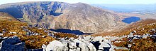
MacGillycuddy's Reeks is a sandstone and siltstone mountain range in the Iveragh Peninsula in County Kerry, Ireland. Stretching 19 kilometres, from the Gap of Dunloe in the east, to Glencar in the west, the Reeks is Ireland's highest mountain range, and includes most of the highest peaks and sharpest ridges in Ireland, and the only peaks on the island over 1,000 metres in height.
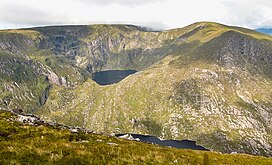
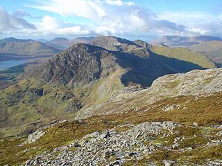
Carrauntoohil, Carrauntoohill or Carrantuohill is the highest mountain in Ireland at 1,038.6 metres. It is on the Iveragh Peninsula in County Kerry, close to the centre of Ireland's highest mountain range, MacGillycuddy's Reeks. Carrauntoohil is composed mainly of sandstone, whose glaciation produced distinctive features on the mountain such as the Eagle's Nest corrie and some deep gullies and sharp arêtes in its east and northeastern faces that are popular with rock and winter climbers.
The Twelve Bens or Twelve Pins, also called the Benna Beola, is a mountain range of mostly sharp-peaked quartzite summits and ridges in the Connemara National Park in County Galway, in the west of Ireland. The widest definition of the range includes the Garraun Complex to the north as well as several isolated peaks to the west, and is designated a 16,163-hectare (39,940-acre) Special Area of Conservation.
Lugnaquilla is the highest of the Wicklow Mountains in Ireland, rising to 925 metres (3,035 ft). It is also the highest Irish mountain outside of County Kerry, and the highest point in County Wicklow and the province of Leinster. Lugnaquilla overlooks the Glen of Imaal to the west and Glenmalure to the east.
Mweelrea is a mountain on the Atlantic coast of County Mayo, Ireland. Rising to 814 metres (2,671 ft), it is the highest mountain in the western province of Connacht, and is noted for its southeastern cliff-lined corries, and its views. Mweelrea overlooks Killary Harbour and is at the heart of a "horseshoe-shaped" massif that includes the peaks of Ben Lugmore and Ben Bury. The massif is called the Mweelrea Mountains or the Mweelrea Range.
Kippure at 757 metres (2,484 ft), is the 56th-highest peak in Ireland on the Arderin scale, and the 72nd-highest peak on the Vandeleur-Lynam scale. Kippure is situated in the far northern sector of the Wicklow Mountains, where it lies on the border of the counties of Dublin and Wicklow in Ireland. Kippure is the County Top for Dublin, and its height and positioning over Dublin city have made its summit an important site for transmission masts, which are highly visible from a distance. Kippure's slopes feed into the Liffey Head Bog which forms the source of the River Liffey. The summit can be easily accessed from the east via a path that lies off the R115 road along the route to the Sally Gap.
Torc Mountain, at 535 metres (1,755 ft), is the 329th–highest peak in Ireland on the Arderin list. It is a popular mountain for hill walkers as it has a stone or boarded path from its base at Torc Waterfall to its summit, which has views of the Lakes of Killarney. Torc Mountain is part of the Mangerton Mountain Group range in County Kerry, Ireland.
Mullaghcleevaun at 849 metres (2,785 ft), is the 15th–highest peak in Ireland on the Arderin scale, and the 20th–highest peak on the Vandeleur-Lynam scale. Mullaghcleevaun is in the central sector of the Wicklow Mountains range, in Wicklow, Ireland; it is the 2nd highest peak in Wicklow after Lugnaquilla. Mullaghcleevaun lies on the main "central spine" of the whole range that runs from Kippure in the north, to Lugnaquillia in the south; and in particular, it lies on the continuous "central boggy ridge" that runs from the Sally Gap to Tonelagee.
Tonelagee, is at 817 metres (2,680 ft), is the 25th–highest peak in Ireland on the Arderin scale, and the 33rd–highest peak on the Vandeleur-Lynam scale. Tonelagee is situated in the central sector of the Wicklow Mountains range, and sits on the main "central spine" of the range that runs from Kippure in the north, to Lugnaquillia in the south; and in particular, the continuous "central boggy ridge" that runs from the Sally Gap in the north, via Mullaghcleevaun, to Tonelagee. Tonelagee is the third highest peak in Wicklow after Lugnaquilla and Mullaghcleevaun.
Purple Mountain at 832 metres (2,730 ft) high, is the 21st–highest peak in Ireland on the Arderin scale, and the 28th–highest according to the Vandeleur-Lynam scale. It is located in County Kerry, and is the highest point of the Purple Mountain Group.
Camaderry at 699 metres (2,293 ft), is the 90th-highest peak in Ireland on the Arderin scale, and the 112th-highest peak on the Vandeleur-Lynam scale. Camaderry is situated in the southern sector of the Wicklow Mountains range, and forms a broad horseshoe around the valley of Glendalough with the hydroelectric station at Turlough Hill 681 metres (2,234 ft), and the mountains of Conavalla 734 metres (2,408 ft), and Lugduff 652 metres (2,139 ft). Camaderry has a subsidiary summit, Camaderry South East Top 677 metres (2,221 ft), and both lie across the deep Wicklow Gap from Tonelagee 817 metres (2,680 ft), which sits on the "central spine" of the Wicklow range.
Binn idir an Dá Log, sometimes anglicized Benadolug, at 702 metres (2,303 ft), is the highest of the Maumturk Mountains in Connemara in County Galway, Ireland. It is at the middle of the long north-west to south-east central spine of the range. The summit is the 87th-highest peak in Ireland on the Arderin list, and the 108th-highest on the Vandeleur-Lynam list.
Torc Waterfall is a 20 metres (66 ft) high, 110 metres (360 ft) long cascade waterfall formed by the Owengarriff River as it drains from the Devil's Punchbowl corrie lake at Mangerton Mountain. The waterfall, which lies at the base of Torc Mountain, in the Killarney National Park, is 4.3 miles from Killarney in County Kerry, Ireland. The waterfall is a popular site on the Ring of Kerry and the Kerry Way tours.
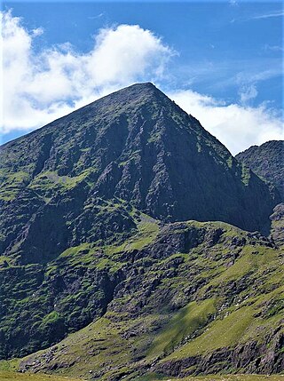
Beenkeragh or Benkeeragh is the second-highest peak in Ireland, at 1,008.2 metres (3,308 ft), on both the Arderin and Vandeleur-Lynam lists. It is part of the MacGillycuddy's Reeks range in County Kerry. Beenkeragh also gives its name the infamous Beenkeragh Ridge, the narrow rocky arete between Beenkeragh and Carrauntoohil, Ireland's highest mountain.
Bencorr at 711 metres (2,333 ft), is the 82nd–highest peak in Ireland on the Arderin scale, and the 102nd–highest peak on the Vandeleur-Lynam scale. Bencorr is situated near the centre of the core massif of the Twelve Bens mountain range in the Connemara National Park in County Galway, Ireland. It is the second-tallest mountain of the Twelve Bens range, after Benbaun 729 metres (2,392 ft); it lies close to Benbaun, separated only by the third-highest mountain in the range of Bencollaghduff 696 metres (2,283 ft), and the col of Maumina.
Garraun at 598 metres (1,962 ft), is the 224th–highest peak in Ireland on the Arderin scale, however, while it is just short of the elevation threshold of 600-metres for other classifications, it does have the prominence to be a Marilyn. Garraun lies on an isolated massif near the mouth of Killary Harbour at the far north sector of the Twelve Bens/Garraun Complex Special Area of Conservation in the Connemara National Park in County Galway. The southern slopes are a scenic backdrop to Kylemore Abbey and Kylemore Lough.
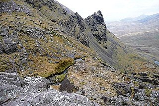
The Hag's Tooth, at 650 metres (2,130 ft) high, is a sharp rock spike which is the 193rd highest peak in Ireland on the Vandeleur-Lynam scale. It is also known as Stumpeenadaff. The Hag's Tooth is situated in the Hag's Glen beside the Eagle's Nest corrie of Carrauntoohil and is part of the MacGillycuddy's Reeks in Kerry.
Derryclare is a mountain at the southern edge of Twelve Bens mountain range in Connemara National Park in County Galway, Ireland. At 677 metres (2,221 ft), it is the 119th–highest peak in Ireland on the Arderin list, and the 145th–highest peak on the Vandeleur-Lynam list. It is the 5th tallest of the core Twelve Bens. The Derryclare Lough on its southern slopes is a scenic location in Connemara, while Derryclare Wood, on its eastern slopes, contains a Statutory Nature Reserve (SRN).
Knocknahillion is one of the Maumturk Mountains of Connemara in County Galway, Ireland. At 607 metres (1,991 ft), it is the 210th–highest peak in Ireland on the Arderin list, and 256th–highest on the Vandeleur-Lynam list. Knocknahillion is in the middle sector of the long north-west to the south-east spine of the Maumturks. The summit is offset to the west of the rocky central ridge of the Maumturks, and its western-facing slopes have a distinctive "diagonal" rock stratification when viewed from the Inagh Valley.
Ben Lugmore at 803 metres (2,635 ft) is the 29th-highest peak in Ireland on the Arderin scale, and the 37th-highest peak on the Vandeleur-Lynam scale. It is in a horseshoe-shaped massif that includes the slightly higher peak of Mweelrea at 814 metres (2,671 ft), the highest mountain in the Irish province of Connacht. The massif is between Killary Harbour and Doo Lough, in County Mayo.
The names of six major Kerry mountains (Mount Brandon, Beenoskee, Mangerton, Purple Mountain, Carrauntoohil, and Coomacarrea) are considered, from the point of view both of a hill-walker and of a toponymist. Difficulties of interpretation are discussed, and some tentative solutions are offered.
Route 28: Mangerton Mountain and Stoompa
The spectacular vistas from the highest point in Killarney National Park have to be earned.
Route 46: Torc Mountain
Walk 15: Mangerton Mountain Circuit (10 km)
This is a strenuous 5 hour (13.5 km) walking route to the peaks of both Mangerton (839m) and Stoompa Mountain (705m) taking in the Devils Punchbowl, Horses Glen and the Tooreencormick Battle Field Site. The walk has spectacular views of the Devil's Punchbowl, MacGillycuddy's Reeks, Horses Glen, Killarney National Park and on a good day south-west to Kenmare Bay.
In 1262, joined by Walter de Burgh with a feudal army and ' a great number of the Irish ', he advanced into Desmond to give battle to Cormac, Fineen's brother, and avenge the slaughter of Callann. The opposing forces met on the slopes of Mangerton, at a place henceforth known as Tuairin Cormaic. Here Gerald Roche, ' the third best baron in Erin ', was slain, but this, we are told, was ' joy with sorrow to Desmond', for Cormac, son of Donnell Got, was slain on the same day, and great losses were suffered on both sides.'