The Sutton Coldfield transmitting station is a broadcasting and telecommunications facility located in Sutton Coldfield, Birmingham, England. In terms of population covered, it is the third most important transmitter in the UK, after Crystal Palace in London and Winter Hill near Bolton.

The Mendip transmitting station is a broadcasting and telecommunications facility on the summit of Pen Hill, part of the Mendip Hills range in Somerset, England, at 305 metres (1,001 ft) above sea level. The station is in St Cuthbert Out civil parish, approximately 2 miles (3.2 km) north-east of Wells. Its mast, 293 m (961 ft) high, was built in 1967 and is the tallest structure in South West England. The mast broadcasts digital television, FM analogue radio and DAB digital radio, and had broadcast analogue colour television from 1967 until 2010.

The Winter Hill transmitting station is a broadcasting and telecommunications site on Winter Hill, at the south eastern boundary of the Borough of Chorley, Lancashire, England, and above Bolton. It is owned and operated by Arqiva.

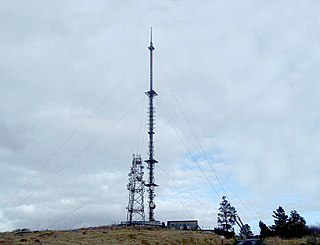
The Arfon transmitting station is a facility for FM, DAB digital radio and television transmission near the villages of Nebo and Nasareth in Gwynedd, northwestern Wales. It includes a 308.5 m (1,012 ft) guyed mast with antennas attached at various heights. The mast is surmounted by a television transmitting antenna, which brings the total height of the structure to 317.4 m (1,041 ft), making it the tallest structure in Wales. It is owned and operated by Arqiva.

The Rowridge transmitting station is a facility for FM radio and television transmission at Rowridge on the Isle of Wight in southern England.

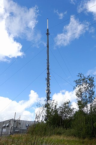
The Wrekin transmitting station is a telecommunications and broadcasting facility on The Wrekin, a hill in the county of Shropshire, England. It includes a 52 metres (171 ft) tall free-standing lattice tower with transmitting antennas attached at various heights. The DTT transmitting arrays add about another 10m to this. It broadcasts digital television, alongside digital and FM (analogue) radio. The station was first proposed in 1966. As The Wrekin is a local beauty spot, many objections had to be overcome and alternative sites analysed before planning consent was given. The transmitter opened in 1975. The building is semi-underground and the tower stands on its roof.
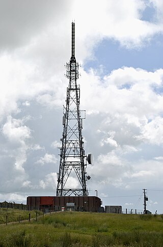
The Llanddona transmitting station is a broadcasting and telecommunications facility, situated at Llanddona, near Beaumaris, on the isle of Anglesey, Wales. It comprises a 106.7 metres (350 ft) guyed mast with antennas attached at various heights. It is owned and operated by Arqiva.

The Wenvoe transmitting station, officially known as Arqiva Wenvoe, is the main facility for broadcasting and telecommunications for South Wales and the West Country. It is situated close to the village of Wenvoe in the Vale of Glamorgan, Wales, in the UK.
The Cairn Hill transmission site is a radio and television broadcasting facility located on a 277 metre hill at Dernacross, 10 km northeast of Longford town in County Longford, Ireland.

2RN is the trading name of RTÉ Transmission Network DAC, a wholly owned subsidiary of Raidió Teilifís Éireann, formerly trading as RTÉNL, which runs Ireland's principal digital terrestrial television and radio broadcast networks. In December 2002 it became an incorporated company and subsidiary of RTÉ; it was previously a division within RTÉ. It operates 12 main TV and radio transmitter sites and many smaller relays and transposers, which carry television and/or radio. It also provides site hosting for mobile telephone operators, the emergency services, wireless broadband and other private mobile communications service providers.

Kippure at 757 metres (2,484 ft), is the 56th-highest peak in Ireland on the Arderin scale, and the 72nd-highest peak on the Vandeleur-Lynam scale. Kippure is situated in the far northern sector of the Wicklow Mountains, where it lies on the border of the counties of Dublin and Wicklow in Ireland. Kippure is the County Top for Dublin, and its height and positioning over Dublin city have made its summit an important site for transmission masts, which are highly visible from a distance. Kippure's slopes feed into the Liffey Head Bog which forms the source of the River Liffey. The summit can be easily accessed from the east via a path that lies off the R115 road along the route to the Sally Gap.

The Strabane transmitting station is a broadcasting and telecommunications facility located at Legfordrum and situated very close to the town of Strabane, in County Tyrone, Northern Ireland. It is owned and operated by Arqiva.

Clermont Carn, also known as Black Mountain, is a mountain that rises to 510 metres (1,670 ft) in the Cooley Mountains of County Louth, Ireland. It is at the border with Northern Ireland, and is also the location of the Clermont Carn transmission site. The mountain's name refers to an ancient burial cairn on its summit, and to Lord Clermont of Ravensdale.
The Preseli transmitting station is a broadcasting and telecommunications facility on the eastern end of the Preseli Mountains, close to the villages of Crymych and Pentre Galar in Pembrokeshire, Wales. It is owned and operated by Arqiva.
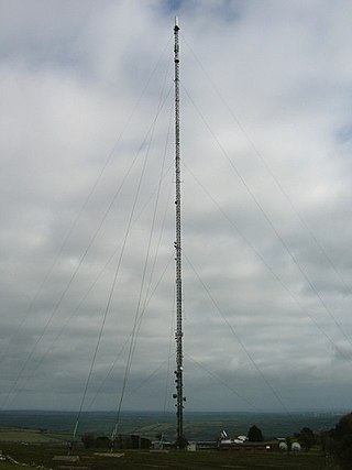
The Oxford transmitting station is a broadcasting and telecommunications facility, situated on land 129.5 metres (425 ft) above Ordnance Datum to the north east of the city of Oxford, in Oxfordshire, England. It has a guyed steel lattice mast which is 154.4 metres (507 ft) in height to the top of the main steel structure. The UHF television antenna, which consist of a vertical array of transmitting panels, is mounted above the steel structure. The total height of the mast to the top of this UHF antenna is 165.7 metres (544 ft). It is owned and operated by Arqiva.

Truskmore is a mountain with a height of 647 metres (2,123 ft) on the border of County Sligo and County Leitrim in Ireland. It is the highest summit in the Dartry Mountains and the highest in Sligo. It is in the middle of a plateau whose edges are marked by high cliffs, including Benbulbin (526m), Benwiskin (514m), Slievemore (597m) and Kings Mountain (462m). The top of Truskmore lies in County Sligo, a short distance from the border with County Leitrim; however, the mountain itself is in both counties.
The Maghera transmission site is situated on a 400m hill located at Killanena in the East of County Clare, Ireland. It is home to one of 2RN's network of radio and television transmitters.

Divis transmitting station is the main high-power UHF and BBC National FM/DAB station that serves County Antrim and parts of County Down.
The Holywell Hill transmission site is located on a 260 metre hill near Killea in County Donegal, Ireland, and is owned and operated by 2RN.

The Spur Hill transmission site is located to the south of the city of Cork, Ireland, just north west of Cork airport, on a hill with a 137 metre elevation.


