
MacGillycuddy's Reeks is a sandstone and siltstone mountain range in the Iveragh Peninsula in County Kerry, Ireland. Stretching 19 kilometres, from the Gap of Dunloe in the east, to Glencar in the west, the Reeks is Ireland's highest mountain range, and includes most of the highest peaks and sharpest ridges in Ireland, and the only peaks on the island over 1,000 metres in height.
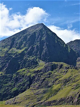
Carrauntoohil or Carrauntoohill is the highest mountain in Ireland at 1,038.6 metres. It is on the Iveragh Peninsula in County Kerry, close to the centre of Ireland's highest mountain range, MacGillycuddy's Reeks. Carrauntoohil is composed mainly of sandstone, whose glaciation produced distinctive features on the mountain such as the Eagle's Nest corrie and some deep gullies and sharp arêtes in its east and northeastern faces that are popular with rock and winter climbers.

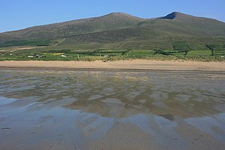
Mount Brandon or Brandon, at 952 metres (3,123 ft), is one of the ten highest peaks in Ireland, being the 8th–highest peak in Ireland on the Arderin list, and the 9th–highest on the Vandeleur-Lynam list. Brandon is the highest Irish mountain outside the MacGillycuddy's Reeks range and has the greatest prominence of any Irish peak except Carrauntoohil, Ireland's highest mountain.

Slieve Donard is the highest mountain in Northern Ireland and the wider province of Ulster, with a height of 850 metres (2,790 ft). The highest of the Mourne Mountains, it is near the town of Newcastle on the eastern coast of County Down, overlooking the Irish Sea. It is also the highest mountain in the northern half of Ireland, and 7th highest on the island.

Slieve Foy or Slieve Foye is a mountain on the Cooley Peninsula in Louth, Ireland. It rises to 589 metres (1,932 ft), making it the highest of the Cooley Mountains and the highest in Louth. It overlooks Carlingford Lough and the village of Carlingford, and is sometimes called Carlingford Mountain.
The Mullaghareirk Mountains is a range of hills in Ireland on the borders of County Cork, County Kerry and County Limerick. The area is also known as Sliabh Luachra. The highest point is Baraveha at 451 metres (1,480 ft). It is bordered by the Blackwater valley to the south, Castleisland to the west, Athea to the north and the Deel valley to the east. Villages in the hills include Rockchapel, Ballydesmond, Brosna, Gneevgullia, Mountcollins, Newmarket, Meelin and Tournafulla. The Allaughaun River, a tributary of the River Feale, rises at the east end of the range.

Torc Mountain, at 535 metres (1,755 ft), is the 329th–highest peak in Ireland on the Arderin list. It is a popular mountain for hill walkers as it has a stone or boarded path from its base at Torc Waterfall to its summit, which has views of the Lakes of Killarney. Torc Mountain is part of the Mangerton Mountain Group range in County Kerry, Ireland.
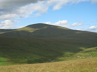
The Mountains of the Central Dingle Peninsula are the generic name given to the mountains that lie on the Dingle Peninsula between the Brandon Group of mountains in the west, and the Slieve Mish Mountains at the eastern end of the peninsula.
Slieve Mish Mountains, is a predominantly sandstone mountain range at the eastern end of the Dingle Peninsula in County Kerry, Ireland. Stretching 19 kilometres, from the first major peak of Barnanageehy outside of Tralee in the east, to Cnoc na Stuaice in near Central Dingle in the west, the range has over 17 material peaks, with the core of the mountain range based around the massif of its highest peak, Baurtregaum, and its deep glacial valleys of Derrymore Glen and Curraheen Glen.

Mangerton or Mangerton Mountain, at 838 metres (2,749 ft), is the 19th-highest peak in Ireland on the Arderin list, and the 26th–highest mountain according to the Vandeleur-Lynam list. Mangerton is the tallest mountain in the Mangerton Mountain Group, also called the Mangerton Mountains or the Mountains of East Kerry, a range that includes five other major mountains that have a height above 2,000 feet (610 m). Mangerton's western slopes lie within the Killarney National Park. On Mangerton's north-western face lies a deep corrie lake called the Devil's Punchbowl, which is a popular scenic destination for hill walkers; although the mountain is often overlooked by walkers due to the proximity of its more scenic and accessible neighbour, Torc Mountain. The far northern slopes of Mangerton was the site of an important 13th-century battle between the Mac Cárthaigh, and the FitzGeralds, known as the "Tooreencormick battle site".

Slievemaan at 759 metres (2,490 ft), is the 54th–highest peak in Ireland on the Arderin scale, and the 70th–highest peak on the Vandeleur-Lynam scale. Slievemaan is situated in the southwen sector of the Wicklow Mountains range, and is part of the large massif of Lugnaquilla 925 metres (3,035 ft), Wicklow's highest mountain. Slievemaan lies at the southern end of the Glen of Imaal.

Table Mountain is a 702-metre (2,303 ft) peak in the southern section of the Wicklow Mountains range in Ireland. With a prominence of only 16 metres (52 ft), it is only listed in a few of the recognised categories of mountains in Ireland; it is the 110th–highest peak on the Vandeleur-Lynam Irish scale. Table Mountain is at the apex of a horseshoe-shaped "boggy" massif with its larger neighbours, Camenabologue 758 metres (2,487 ft) and Conavalla 734 metres (2,408 ft) that sit at the head of the Glenmalure valley; all three peaks lie close to the "central spine" of the range as it runs from Kippure in the north, to Lugnaquillia in the south. There is no recorded Irish language name for Table Mountain, and it has no connection with Table Mountain in Cape Town, South Africa.
Slieve Beagh is a mountainous area straddling the border between County Monaghan in the Republic of Ireland and County Fermanagh and County Tyrone in Northern Ireland. A point just east of its summit is the highest point in Monaghan; however the true summit is on the Fermanagh-Tyrone border. The point where the three counties meet, is referred to as the "Three County Hollow".

Baurtregaum at 851 metres (2,792 ft), is the 13th–highest peak in Ireland on the Arderin scale, and the 18th–highest peak on the Vandeleur-Lynam scale. Baurtregaum is situated at the centre of the massif of the Slieve Mish Mountains in the Dingle Peninsula in Kerry, Ireland, and is the tallest mountain of the Slieve Mish range, with a number of major subsidiary summits.
Sawel Mountain is the highest peak in the Sperrin Mountains, and the 8th highest in Northern Ireland. It is also the highest mountain in Northern Ireland outside of the Mourne Mountain range located in County Down.
Mount Eagle or Mounteagle may refer to:

Caherconree at 835 metres (2,740 ft), is the 20th–highest peak in Ireland on the Arderin scale, and the 27th–highest peak on the Vandeleur-Lynam scale. Caherconree is the 2nd-highest mountain in the Slieve Mish Mountains in the Dingle Peninsula in Kerry, Ireland, and one of its southerly spurs is the site of an ancient stone promontory fort, which is a protected National Monument.

Knocknadobar at 690 metres (2,260 ft), is the 102nd–highest peak in Ireland on the Arderin scale, and the 123rd–highest peak in Ireland according to the Vandeleur-Lynam scale. Knocknadobar is one of the main mountains of the Iveragh Peninsula in County Kerry, Ireland, and has been one of the most important sites of pilgrimage in Ireland since medieval times.

Carhoo Hill or Ballymacadoyle Hill is a large hill south-west of Dingle in County Kerry, Ireland.
Slieve Coillte is a hill in the south of County Wexford, Ireland. The hill is the highest point on the Hook peninsula, with an elevation of 268.5 metres (881 ft).


