Knockmealdown

Last updated
Knockmealdown
Cnoc Mhaoldomhnaigh
Irl-Knockmealdown.jpg
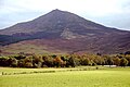
Knockmealdown east face and summit
The screes are steep and barren looking though sheep are grazing
Highest point
Elevation 792 m (2,598 ft) [1]
Prominence 683 m (2,241 ft) [1]
Parent peak Galtymore
Listing County top (Waterford), P600, Marilyn, Hewitt
Coordinates 52°13′41″N7°54′57″W / 52.22806°N 7.91583°W / 52.22806; -7.91583 Coordinates: 52°13′41″N7°54′57″W / 52.22806°N 7.91583°W / 52.22806; -7.91583
Naming
English translationhill of Maoldomhnaigh [1]
Language of name Irish
Geography
Ireland relief location map.png
Red triangle with thick white border.svg
Knockmealdown
Ireland
Location Waterford, Republic of Ireland
Parent range Knockmealdown Mountains
OSI/OSNI grid S058084
Topo map OSi Discovery 74
Geology
Mountain type Medium grained pink-purple sandstone bedrock [1]
Climbing
Easiest route hiking

Knockmealdown (Irish : Cnoc Mhaoldomhnaigh, meaning 'hill of Maoldomhnach') is the highest peak of the Knockmealdown Range of mountains, located on the border between Co Tipperary and Co Waterford. [1]

Contents

Geography

The peak itself is located in County Waterford and is the highest point in that county. However, since the county border generally follows the summit line the main peaks are actually in both county Tipperary and in County Waterford (OSI Discovery Map 75).

Name

Knockmealdown is the Anglicised form of an older Irish name. The original Irish name is widely believed to be Cnoc Mhaoldomhnaigh, meaning "Muldowneys' hill". [2] It has also been suggested that it is derived from Cnoc Maol Donn, meaning "bald brown hill". [3] In 1654 the name was recorded as Knockmealdowny, indicating there was an extra syllable at the end. [2] [3]

Hill walking

The peak is easily accessed from the west, via the layby overlooking Bay Lough on the Vee Gap. This involves first climbing Sugarloaf Hill. It may also be climbed by following the Glannandaree stream from the carpark at the point where the R668 and R669 roads meet.

Summit of Knockmealdown Knockmealdown Summit.jpg
Summit of Knockmealdown

See also

Related Research Articles

MacGillycuddys Reeks Mountain range in Kerry, Ireland

MacGillycuddy's Reeks is a sandstone and siltstone mountain range in the Iveragh Peninsula in County Kerry, Ireland. Stretching 19 kilometres, from the Gap of Dunloe in the east, to Glencar in the west, the Reeks is Ireland's highest mountain range, and includes most of the highest peaks and sharpest ridges in Ireland, and the only peaks on the island over 1,000 metres in height.

Lists of mountains in Ireland Highest mountains in Ireland

In these lists of mountains in Ireland, those within Northern Ireland, or on the Republic of Ireland – United Kingdom border, are marked with an asterisk, while the rest are within the Republic of Ireland. Where mountains are ranked by height, the definition of the topographical prominence used to classify the mountain, is noted. In British definitions, a height of 600 metres (1,969 ft) is required for a mountain, whereas in Ireland, a lower threshold of 500 metres (1,640 ft) is sometimes advocated.

Mweelrea Mountain in Mayo, Ireland

Mweelrea at 814 metres (2,671 ft), is the 26th-highest peak in Ireland on the Arderin scale, and the 34th-highest peak on the Vandeleur-Lynam scale. Mweelrea is situated near the apex of a "horseshoe-shaped" massif that includes the peaks of Ben Lugmore and Ben Bury, and which is located between Killary Harbour and Doo Lough, in Mayo, Ireland. Mweelrea is the provincial top for Connacht, and is noted for its southeastern cliff lined corries, and its views. The massif is called the Mweelrea Mountains or the Mweelrea Range.

Galtymore Mountain in Tipperary/Limerick, Ireland

Galtymore or Galteemore, is a mountain in the province of Munster, Ireland. At 917.9 metres (3,011 ft), it is one of Ireland's highest mountains, being the 12th-highest on the Arderin list, and 14th-highest on the Vandeleur-Lynam list. Galtymore has the 4th-highest topographic prominence of any peak in Ireland, which classifies Galtymore as a P600, or "major mountain". It is also one of the 13 Irish Munros.

Knockmealdown Mountains

The Knockmealdown Mountains is a mountain range located on the border of counties Tipperary and Waterford in Ireland, running east and west between the two counties. The highest peak of the range is Knockmealdown, in County Waterford. On the western side of the summit, the range is crossed by a high pass called ‘The Vee’ through which runs the old mail coach road from Lismore to Clogheen.

Sugarloaf Hill (Knockmealdowns) Mountain in Tipperary/Waterford, Ireland

Sugarloaf Hill is a mountain peak located in the Knockmealdown Mountains on the border between County Tipperary and County Waterford.

Benbaun Mountain in Galway, Ireland

Benbaun at 729 metres (2,392 ft), is the 72nd–highest peak in Ireland on the Arderin scale, and the 88th–highest peak on the Vandeleur-Lynam scale. Benbaun is situated at the centre of the core massif of the Twelve Bens mountain range in the Connemara National Park in Galway, Ireland, and is the tallest mountain of the Twelve Bens range, and the county top for Galway.

Knockboy Mountain in Cork, Ireland

Knockboy is a 706-metre-high mountain on the border between counties Cork and Kerry in Ireland.

Slieve Mish Mountains Mountain range in Kerry, Ireland

Slieve Mish Mountains, is a predominantly sandstone mountain range at the eastern end of the Dingle Peninsula in County Kerry, Ireland. Stretching 19 kilometres, from the first major peak of Barnanageehy outside of Tralee in the east, to Cnoc na Stuaice in near Central Dingle in the west, the range has over 17 material peaks, with the core of the mountain range based around the massif of its highest peak, Baurtregaum, and its deep glacial valleys of Derrymore Glen and Curraheen Glen.

Cnoc na Péiste Mountain in Kerry, Ireland

Cnoc na Péiste, anglicised Knocknapeasta, at 988 metres (3,241 ft), is the fourth-highest peak in Ireland, on the Arderin and Vandeleur-Lynam lists. Cnoc na Péiste is part of the MacGillycuddy's Reeks range in County Kerry. It is one of only two 3,000 ft peaks in the Reeks with a prominence above the Marilyn threshold of 150 metres, and is the highest summit of the Eastern Reeks. In 1943, a USAAF plane crashed into the mountain, killing all five crew, and parts of the wreckage can still be seen in Lough Cummeenapeasta.

Knocknadobar Mountain in Kerry, Ireland

Knocknadobar at 690 metres (2,260 ft), is the 102nd–highest peak in Ireland on the Arderin scale, and the 123rd–highest peak in Ireland according to the Vandeleur-Lynam scale. Knocknadobar is one of the main mountains of the Iveragh Peninsula in County Kerry, Ireland, and has been one of the most important sites of pilgrimage in Ireland since medieval times.

The Big Gun Mountain in Kerry, Ireland

The Big Gun, at 939 metres (3,081 ft) high, is the ninth-highest peak in Ireland on the Arderin list, or the tenth-highest according to the Vandeleur-Lynam list. It is part of the MacGillycuddy's Reeks in County Kerry, and is also known as Lackagarrin or Foilnabreachaun.

Caher West Top Mountain in Kerry, Ireland

Caher West Top at 973.4 metres, is the fifth-highest peak in Ireland on the Irish Vandeleur-Lynam classification, and part of the MacGillycuddy's Reeks range. Caher West Top is the only Furth to have a prominence below 30 metres (98 ft).

The Bones Mountain in Kerry, Ireland

The Bones, at 957 metres (3,140 ft) high, is the seventh-highest peak in Ireland on the Arderin list, or the eighth-highest according to the Vandeleur-Lynam list. It is part of the MacGillycuddy's Reeks in County Kerry, and is a small sharp peak on the dramatic Beenkeragh Ridge, and is sometimes mistaken with The Bone, the north-east spur of Maolán Buí, which descends into the Hag's Glen.

Cnoc an Chuillinn Mountain in Kerry, Ireland

Cnoc an Chuillinn, at 958 metres (3,143 ft), is the sixth-highest peak in Ireland on the Arderin list and the seventh-highest peak in Ireland on the Vandeleur-Lynam list. The name is sometimes incorrectly anglicised to Knockacullion, which is a name used for peaks and townlands in other parts of Ireland. Cnoc an Chuillinn is part of the MacGillycuddy's Reeks range in County Kerry.

Brassel Mountain Mountain in Kerry, Ireland

Brassel Mountain at 575 metres (1,886 ft), is the 261-st highest peak in Ireland, on the Arderin scale. It is part of the MacGillycuddy's Reeks range in County Kerry. Brassel Mountain is the south-east spur of the larger neighbouring peaks, Cnoc an Chuillinn 958 metres (3,143 ft), and Cnoc an Chuillinn East Top 926 metres (3,038 ft). Because of its positioning away from the main ridge of the Reeks, and away from the glens used to access the Reeks, Brassel is less frequently climbed, but can be used as an exit, or entry point to the main ridge.

Cnoc na Toinne Mountain in Kerry, Ireland

Cnoc na Toinne, at 845 metres (2,772 ft), is the 17th-highest peak in Ireland on the Arderin list, and the 23rd-highest peak in Ireland on the Vandeleur-Lynam list. It is part of the MacGillycuddy's Reeks range in County Kerry. Cnoc na Toinne lies between the Coomloughra Reeks and the Eastern Reeks, and is just above the col of the Devil's Ladder, a popular route for climbing Carrauntoohil, Ireland's highest mountain.

Knocknahillion Mountain in Galway, Ireland

Knocknahillion at 607 metres (1,991 ft), is the 210th–highest peak in Ireland on the Arderin scale, and the 256th–highest peak on the Vandeleur-Lynam scale. Knocknahillion is situated in the middle sector of the long north-west to south-east cental spine of the Maumturks mountain range in the Connemara National Park in County Galway, Ireland. The summit is offset to the west of the rocky central ridge of the Maumturks, and its western facing slopes have a distinctive "diagonal" rock stratification when viewed from the Inagh Valley.

Benbrack Mountain in Galway, Ireland

Benbrack at 582 metres (1,909 ft), is the 251st–highest peak in Ireland on the Arderin scale; while it does not have the elevation to be a Vandeleur-Lynam, it has the prominence to rank as a Marilyn. Benbrack is situated on its own small massif to the north of the core Twelve Bens mountain range in the Connemara National Park in Galway, Ireland. It is the 10th-tallest of the core Twelve Bens, and is linked by a deep col to Muckanaght, which is itself attached by a high ridge to the tallest mountain of the Twelve Bens range, Benbaun at 729 metres (2,392 ft).

Knocknafallia Mountain in County Waterford, Ireland

Knocknafallia is a 668 m (2,192 ft) high mountain in County Waterford, Ireland.

References

  1. 1 2 3 4 5 "Knockmealdown". MountainViews . Retrieved 2 June 2019.
  2. 1 2 Placenames Database of Ireland
  3. 1 2 "Knockmealdown Mountains". MountainViews. Retrieved 24 February 2009.