Related Research Articles
Highland is a council area in the Scottish Highlands and is the largest local government area in the United Kingdom. It was the 7th most populous council area in Scotland at the 2011 census. It shares borders with the council areas of Aberdeenshire, Argyll and Bute, Moray and Perth and Kinross. Their councils, and those of Angus and Stirling, also have areas of the Scottish Highlands within their administrative boundaries.

Cromarty is a town, civil parish and former royal burgh in Ross and Cromarty, in the Highland area of Scotland. Situated at the tip of the Black Isle on the southern shore of the mouth of Cromarty Firth, it is 5 miles (8 km) seaward from Invergordon on the opposite coast. In the 2001 census, it had a population of 719.
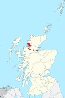
Cromartyshire is a historic county in the Highlands of Scotland, comprising the medieval "old shire" around the county town of Cromarty and 22 enclaves and exclaves transferred from Ross-shire in the late 17th century. The largest part, six times the size of the old shire, is Coigach, northwest from Ullapool. In 1890, Cromartyshire was merged with Ross-shire into the administrative county of Ross and Cromarty. In 1975, the resulting county was combined with Caithness, Inverness-shire, Nairnshire, Sutherland, and parts of Argyllshire and Morayshire to form the Highland council area.

The shires of Scotland, or counties of Scotland, are historic subdivisions of Scotland established in the Middle Ages and used as administrative divisions until 1975. Originally established for judicial purposes, from the 17th century they started to be used for local administration purposes as well. The areas used for judicial functions (sheriffdoms) came to diverge from the shires, which ceased to be used for local government purposes after 1975 under the Local Government (Scotland) Act 1973.

Dingwall is a town and a royal burgh in the Highland council area of Scotland. It has a population of 5,491. It was an east-coast harbour that now lies inland. Dingwall Castle was once the biggest castle north of Stirling. On the town's present-day outskirts lies Tulloch Castle, parts of which may date back to the 12th century. In 1411 the Battle of Dingwall is said to have taken place between the Clan Mackay and the Clan Donald.

Sutherland is a historic county, registration county and lieutenancy area in the Highlands of Scotland. Its county town is Dornoch. Sutherland borders Caithness and Moray Firth to the east, Ross-shire and Cromartyshire to the south and the Atlantic to the north and west. Like its southern neighbour Ross-shire, Sutherland has some of the most dramatic scenery in the whole of Europe, especially on its western fringe where the mountains meet the sea. These include high sea cliffs, and very old mountains composed of Precambrian and Cambrian rocks.

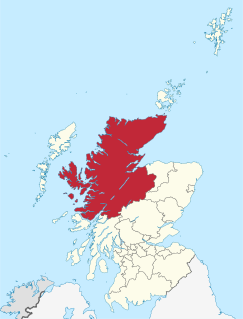
Ross and Cromarty, sometimes referred to as Ross-shire and Cromartyshire, is a variously defined area in the Highlands and Islands of Scotland. There is a registration county and a lieutenancy area in current use, the latter of which is 8,019 square kilometres in extent. Historically there has also been a constituency of the Parliament of the United Kingdom, a local government county, a district of the Highland local government region and a management area of the Highland Council. The local government county is now divided between two local government areas: the Highland area and Na h-Eileanan Siar. Ross and Cromarty border Sutherland to the north and Inverness-shire to the south.

Ross is a region of Scotland. One of the provinces of Scotland from the 9th century, it gave its name to a later earldom and to the counties of Ross-shire and, later, Ross and Cromarty. The name Ross allegedly derives from a Gaelic word meaning "headland", perhaps a reference to the Black Isle. Another possible origin is the West Norse word for Orkney – Hrossey – meaning horse island; the area once belonged to the Norwegian earldom of Orkney. Ross is a historical comital region, perhaps predating the Mormaerdom of Ross. It is also a region used by the Church, with the Presbytery of Ross being part of the Synod of Ross, Sutherland and Caithness.

Càrn Eige, sometimes spelt Càrn Eighe, is a mountain in the north of Scotland. At an elevation of 1,183 metres (3,881 ft) above sea level, it is the highest mountain in Scotland north of the Great Glen, the twelfth-highest summit above sea level in the British Isles, and, in terms of relative height, it is the second-tallest mountain in the British Isles after Ben Nevis. The highpoint of the historic county of Ross and Cromarty, it is the twin summit of the massif, being mirrored by the 1,181-metre (3,875 ft) Mam Sodhail, to the south on the same ridge.
The Black Isle is a peninsula within Ross and Cromarty, in the Scottish Highlands. It includes the towns of Cromarty and Fortrose, and the villages of Culbokie, Jemimaville, Rosemarkie, Avoch, Munlochy, Tore, and North Kessock, as well as numerous smaller settlements. About 12,000 people live on the Black Isle, depending on the definition.

Na h-Eileanan an Iar, formerly Western Isles, is a constituency of the House of Commons of the Parliament of the United Kingdom, created in 1918. It elects one Member of Parliament (MP) by the first past the post system of election.
Ross and Cromarty was a county constituency of the House of Commons of the UK Parliament from 1832 to 1983. It elected one Member of Parliament (MP) using the first-past-the-post voting system.
The Lord Lieutenant of Ross and Cromarty, is the British monarch's personal representative in an area which has been defined since 1975 as consisting of the local government districts of Ross and Cromarty and Skye and Lochalsh in Scotland, and this definition was renewed by the Lord-Lieutenants (Scotland) Order 1996. Previously, the area of the lieutenancy was the county of Ross and Cromarty, which was abolished as a local government area by the Local Government (Scotland) Act 1973. The districts were created, under the 1973 act as districts of the two-tier Highland region and abolished as local government areas under the Local Government (Scotland) Act 1994, which turned the Highland region into a unitary council area.
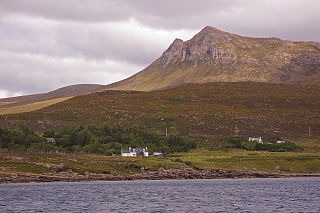
Coigach is a peninsula north of Ullapool, in Wester Ross in the Northwest Highlands of Scotland. The area consists of a traditional crofting and fishing community of a couple of hundred houses located between mountain and shore on a peninsula looking over the Summer Isles and the sea. The main settlement is Achiltibuie. Like its northerly neighbour, Assynt in Sutherland, Coigach has mountains which rise sharply from quiet, lochan-studded moorland, and a highly indented rocky coast with many islands, bays and headlands. The highest summit is Ben Mor Coigach at 743 metres; the distinctive profile of Stac Pollaidh is the other main peak within Coigach. The scenic qualities of Coigach, along with neighbouring Assynt, have led to the area being designated as the Assynt-Coigach National Scenic Area, one of 40 such areas in Scotland.

Ross-shire is a historic county in the Scottish Highlands. The county borders Sutherland to the north and Inverness-shire to the south, as well as having a complex border with Cromartyshire – a county consisting of numerous enclaves or exclaves scattered throughout Ross-shire's territory. Ross-shire includes most of Ross along with Lewis in the Outer Hebrides. Dingwall is the traditional county town. The area of Ross-shire is based on that of the historic province of Ross, but with the exclusion of the many enclaves that form Cromartyshire.

Tarbat is a civil parish in Highland, Scotland, in the north-east corner of Ross and Cromarty.
Cromartie or Cromarty may refer to:
Events from the year 1890 in Scotland.
The Sheriff of Ross, Cromarty and Sutherland was historically the office responsible for enforcing law and order in Ross-shire, Cromarty and Sutherland, Scotland and bringing criminals to justice.
References
- ↑ Abolished as a county in 1890, Cromartyshire was a distinct county consisting chiefly of the Black Isle, with the county town of Cromarty, and the district of Ullapool, with a number of enclaves scattered in the body of Ross-shire, in between. The highest point of the County of Cromarty is Sgurr Mor in the Fannichs at OS grid reference NH200694. It is 1,110 m high - which would have made it 7th in the list
| British Isles |  | |
|---|---|---|
| Scotland | ||
| Outside Scotland | ||
| England | ||
| Ireland | ||
| County tops | ||