
MacGillycuddy's Reeks is a sandstone and siltstone mountain range in the Iveragh Peninsula in County Kerry, Ireland. Stretching 19 kilometres, from the Gap of Dunloe in the east, to Glencar in the west, the Reeks is Ireland's highest mountain range, and includes most of the highest peaks and sharpest ridges in Ireland, and the only peaks on the island over 1,000 metres in height.
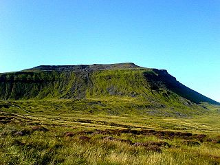
The mountains of Whernside, Ingleborough and Pen-y-ghent are collectively known as the Three Peaks. The peaks, which form part of the Pennine range, encircle the head of the valley of the River Ribble in the Yorkshire Dales National Park in the North of England.

Helvellyn is a mountain in the English Lake District, the highest point of the Helvellyn range, a north–south line of mountains to the north of Ambleside, between the lakes of Thirlmere and Ullswater.

Skiddaw is a mountain in the Lake District National Park in England. Its 931-metre (3,054 ft) summit is traditionally considered to be the fourth-highest peak but depending on what topographic prominence is thought to be significant is also variously ranked as the third- and the sixth-highest in England. It lies just north of the town of Keswick, Cumbria, and dominates the skyline in this part of the northern lakes. It is the simplest of the Lake District mountains of this height to ascend and, as such, many walking guides recommend it to the occasional walker wishing to climb a mountain. This is the first summit of the fell running challenge known as the Bob Graham Round when undertaken in a clockwise direction.

The Old Man of Coniston is a fell in the Furness Fells of the Lake District in Cumbria, England, and is the highest point of the historic county of Lancashire. It is at least 2,632.62 feet (802.42 m) high, and lies to the west of the village of Coniston and the lake, Coniston Water. The fell is sometimes known by the alternative name of Coniston Old Man, or simply The Old Man. The mountain is popular with tourists and fell-walkers with a number of well-marked paths to the summit. The mountain has also seen extensive copper and slate mining activity for eight hundred years, and the remains of abandoned mines and spoil tips are a significant feature of the north-east slopes.

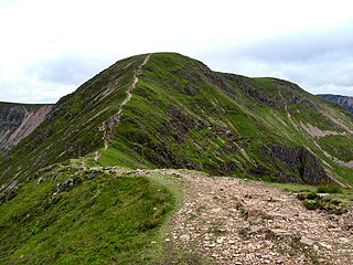
The Aonach Eagach is a large mountain ridge in the Scottish Highlands, marking the northern edge of Glen Coe. It stretches east–west for several miles and includes two Munro summits: Sgùrr nam Fiannaidh at 967 m (3,175 ft) high, and Meall Dearg at 952 m (3,124 ft) high. The ridge is very rocky and the route along it requires scrambling ability. The slopes to each side are extremely dangerous, with steep grass-and-scree slopes hiding even steeper slopes which end in cliffs on both north and south sides of the ridge.

Great Dodd is a mountain or fell in the English Lake District. It stands on the main ridge of the Helvellyn range, a line of mountains which runs in a north–south direction between the lakes of Thirlmere and Ullswater in the east of the Lake District. Great Dodd, with a height of 857 metres (2,812 ft) is the highest of the fells in this range to the north of Sticks Pass.

The Southern Uplands are the southernmost and least populous of mainland Scotland's three major geographic areas. The term is used both to describe the geographical region and to collectively denote the various ranges of hills and mountains within this region. An overwhelmingly rural and agricultural region, the Southern Uplands are partly forested and contain many areas of open moorland - the hill names in the area are congruent with these characteristics.

Stybarrow Dodd is a mountain or fell in the English Lake District. It stands immediately north of Sticks Pass on the main ridge of the Helvellyn range in the Eastern Fells, which is situated between the lakes of Thirlmere and the Ullswater.
Crag Hill is a mountain in the North Western part of the English Lake District. It was formerly known as Eel Crag; however, the Ordnance Survey now marks Eel Crag as referring to the northern crags of the fell. It is not to be confused with another Crag Hill lying on the border of North Yorkshire.

Knott is a mountain in the northern part of the English Lake District. It is the highest point of the Back o'Skiddaw region, an area of wild and unfrequented moorland to the north of Skiddaw and Blencathra. Other tops in this region include High Pike, Carrock Fell and Great Calva. The fell's slopes are mostly smooth, gentle, and covered in grass, with a few deep ravines. It stands a long way from a road and requires a long walk across the moor top get to it; this, as well as the fact that it is hidden from the rest of the Lake District by the two aforementioned giants, make it one of the most unfrequented tops in the Lakes. When it is climbed it is most often from Mungrisdale or from the north via Great Sca Fell. The word Knott is of Cumbric origin, and means simply "hill".

Sgurr na Lapaich is a mountain in the Northwest Highlands of Scotland, situated north of Loch Mullardoch in the high ground that separates Glen Cannich and Glen Strathfarrar. The mountain reaches a height of 1,150 metres, and is the fourth-highest mountain north of the Great Glen. There is no higher ground to the north of it in Great Britain.

Whinlatter is a small fell in the north west of the English Lake District, just north of the Whinlatter Pass. It is easily climbed from the top of the Whinlatter Pass, through the Forestry England plantations. The Whinlatter Visitor's Centre, a popular tourist attraction, is on the south side of the fell. The hill is part of a horseshoe around the valley of Aiken Beck. The fell's name originates from a combination of the Old Norse and Gaelic languages. With the Old Norse word 'hvin' meaning gorse or furze, and the Gaelic word 'lettir' meaning slope, the name translates as "The Gorse or furze-covered slope".

Watson's Dodd is a fell in the English Lake District, a minor rise on the main ridge of the Helvellyn range in the Eastern Fells, but a prominent shoulder on the west side of that range.

Ben Mor Coigach is the highest point along a ridge rising steeply from Loch Broom, in the far northwest of Scotland. It rises above the Coigach peninsula in the county of Ross and Cromarty, 10 kilometres northwest of Ullapool, reaching a height of 743 metres (2,438 ft). Its coastal position, combined with its high topographic prominence to height ratio, provides a spectacular panorama, sweeping from Ullapool across to the Summer Isles and north over the Coigach to the distinctive peaks of the Assynt, as well as more distant views to Skye and the Outer Hebrides, conditions permitting. The area is a Scottish Wildlife Trust nature reserve.

White Coomb is a hill in the Moffat Hills range, part of the Southern Uplands of Scotland. Its broad summit is the highest point in the range and the registration county of Dumfriesshire, as well as being the fourth highest point in southern Scotland, however, despite this, it is largely concealed by other hills on all sides except its east and south east, making this the only direction from which its full scale can be seen.

The Moffat Hills are a range of hills in the Southern Uplands of Scotland. They form a roughly triangular shape with a west facing side, a north facing side, and a south-east facing side. It is 17 kilometres from east to west across this triangle and some 16 kilometres north to south. The highest point is White Coomb at 821 m (2694 ft). The town of Moffat lies just south of the Moffat hills and along with Tweedsmuir, at the northern extremity, is the only centre of population around these hills. In some older maps, the northern part of the Moffat Hills is called the Tweedsmuir Hills, but can also be known by the title Manor Hills.

The Lowther Hills, also sometimes known as the Lowthers, are an extensive area of hill country in the Southern Uplands of Scotland, though some sub-ranges of hills in this area also go under their own local names - see "Hillwalking" below. They form a roughly rhomboidal or lozenge shape on the map with the acute angles being to north and south. It has river valleys along its boundaries to north east (Clydesdale) and south west (Nithsdale) which carry the two largest arterial routes northwards into the west side of the Central Belt of Scotland. A string of small towns have long since developed along these routes. Most of the Lowther Hills lie in the Administrative County of Dumfries and Galloway, though part in the administrative county of South Lanarkshire moves into them around the village of Leadhills and the Daer Reservoir.
The Manor Hills, also known as the Tweedsmuir Hills, are a range of hills south of Peebles in the Scottish Borders, one of the ranges which collectively form the Southern Uplands. They are separated from the Moffat Hills by the Talla Reservoir, Megget Reservoir and St. Mary's Loch, the Moorfoot Hills by the A72 and the Culter Hills in South Lanarkshire by the A701. The western portion of the hills are designated as the 'Tweedsmuir Hills' Site of Special Scientific Interest and the 'Upper Tweeddale' National Scenic Area, with the major tributary rivers designated as Special Areas of Conservation.

The Culter Hills, Coulter Fells or variations thereof, are a range of hills, part of the Southern Uplands of Scotland. They are neighboured to the east by the Manor Hills and are split roughly in half by the border between South Lanarkshire and the Scottish Borders.

