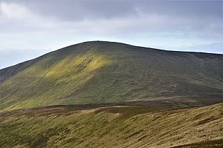
Culter Fell is a hill in the Culter Hills range, part of the Southern Uplands of Scotland. It is the county top of the historic county of Lanarkshire, as well as the highest point in South Lanarkshire council area. It is the culmination of a network of ridges that lie south of the village of Coulter, close to the town of Biggar.

Kirriereoch Hill is a hill in the Range of the Awful Hand, a sub-range of the Galloway Hills range, part of the Southern Uplands of Scotland. It lies on the border of the old counties of Ayrshire and Kirkcudbrightshire, or the modern regions of Dumfries and Galloway and South Ayrshire. A boundary wall near the summit is the highest point in South Ayrshire and Ayrshire as a whole. Kirriereoch Hill was classified as a Corbett and Marilyn but then deleted from these lists in 1984 due to not being thought to achieve the respective prominence criteria. In August 2015 the hill was relisted as a Marilyn after having been surveyed to have a 150.2 m prominence. However, since this is less than the 152.4 m required, the hill will not be re-listed as a Corbett.

White Coomb is a hill in the Moffat Hills range, part of the Southern Uplands of Scotland. Its broad summit is the highest point in the range and the registration county of Dumfriesshire, as well as being the fourth highest point in southern Scotland, however, despite this, it is largely concealed by other hills on all sides except its east and south east, making this the only direction from which its full scale can be seen.

Green Lowther is a hill in the Lowther Hills range, part of the Southern Uplands of Scotland. It is the highest point of the Lowther Hills and lies in Lanarkshire, east of the town of Sanquhar. A microwave array once stood at the summit, however a telecommunications mast remains next to a transmitter station. The private service road which makes its way up neighbouring Lowther Hill, continuing over Green Trough to the summit is the second highest paved road in Britain after Great Dun Fell in the Pennines and the highest road of any kind in Scotland.

Windy Standard is a hill in the Carsphairn and Scaur Hills range, part of the Southern Uplands of Scotland. It lies in Dumfries and Galloway, south of the town of New Cumnock. Once a remote hill to the northeast of Cairnsmore of Carsphairn, its summit area and slopes are now home to a series of expanding large windfarm sites, the earliest of which used to be the largest windfarm in Scotland.

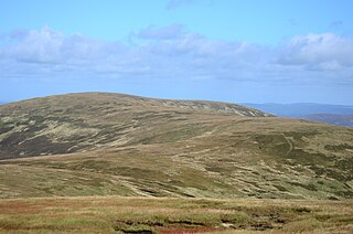
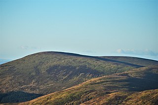
Gathersnow Hill is a hill in the Culter Hills range, part of the Southern Uplands of Scotland. It lies west of the village of Tweedsmuir on the border of the Scottish Borders and South Lanarkshire. The second highest of the Culter Hills after Culter Fell to the north, the two Grahams are often climbed together.
Dollar Law is a hill in the Manor Hills range, part of the Southern Uplands of Scotland. The third highest in the range and the Scottish Borders and fifth highest in southern Scotland, it is frequently climbed with its neighbours Broad Law and Cramalt Craig to the southwest from their direction or as a detour from the hills to the northwest near Drumelzier. Thief's Road, a historic heritage path, passes just south of the summit.

Milldown is a hill in the Rhinns of Kells, a sub-range of the Galloway Hills range, part of the Southern Uplands of Scotland. It is located immediately north of Meikle Millyea - between these two hills lie the Lochans of Auchniebut, a series of small water bodies at an approximate elevation of 650m - possibly the highest permanent water bodies in the Southern Uplands. As well as this, the hill is also flanked on its SW side by forest plantation - possibly the highest planted commercial forestry in the Southern Uplands. Like most of its neighbours, it is most easily climbed from the east at Forrest Lodge.
The Manor Hills, also known as the Tweedsmuir Hills, are a range of hills south of Peebles in the Scottish Borders, one of the ranges which collectively form the Southern Uplands. They are separated from the Moffat Hills by the Talla Reservoir, Megget Reservoir and St. Mary's Loch, the Moorfoot Hills by the A72 and the Culter Hills in South Lanarkshire by the A701. The western portion of the hills are designated as the 'Tweedsmuir Hills' Site of Special Scientific Interest and the 'Upper Tweeddale' National Scenic Area, with the major tributary rivers designated as Special Areas of Conservation.
Middle Hill is a hill in the Manor Hills range, part of the Southern Uplands of Scotland. It is often climbed from Drumelzier to the north or Stanhope Farm to the west, but ascents from the Manor Valley to the east are also possible.

Black Law is a hill in the Manor Hills range, part of the Southern Uplands of Scotland. One of the more remote Donalds, it does not easily combine into a round with other hills in the area and requires traversing rough terrain to reach the top. Common ascents are as part of an extended Dun Rig Horseshoe to the north-east, from the south at the Megget Reservoir or, most easily, from the Manor Valley itself.

Meaul is a hill in the Rhinns of Kells, a sub-range of the Galloway Hills range, part of the Southern Uplands of Scotland. It is climbed from a number of directions; most commonly from Garryhorn near Carsphairn, often as part of a complete traverse of the ridge.

Ballencleuch Law is a hill in the Lowther Hills range, part of the Southern Uplands of Scotland. Surrounded on most sides by tracks or roads, there are various routes to the summit, but the most frequent ascents are from Durisdeer or the Daer Reservoir.
Loch Fell is a hill in the Ettrick Hills range, part of the Southern Uplands of Scotland. Close to the Southern Upland Way, routes of ascent frequently incorporate its track and it is almost always climbed along with the neighbouring hills.

Capel Fell is a hill in the Ettrick Hills range, part of the Southern Uplands of Scotland. Close to the Southern Upland Way, routes of ascent frequently incorporate its track, however the track from Selcoth Fisheries to the west is also popular. It is frequently climbed with the neighbouring hills.

Andrewhinney Hill is a hill in the Ettrick Hills range, part of the Southern Uplands of Scotland. It is the highest summit of a ridge that runs parallel to the A708 road on its southern side, with the Grey Mare's Tail in the Moffat Hills directly opposite. The northwestern slopes are designated as part of the 'Moffat Hills' SSSI and SAC.
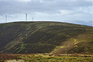
Hillshaw Head is a hill in the Culter Hills range, part of the Southern Uplands of Scotland. An extension to the Clyde Wind Farm was commissioned in 2017 which partially built upon its slopes. It is most frequently climbed with the neighbouring hills as part of a round.

Hudderstone is a hill in the Culter Hills range, part of the Southern Uplands of Scotland. Normally ascended as part of a popular round, its southern flanks are dotted with turbines from the Clyde Extension Wind Farm.

Bell Craig is a hill in the Ettrick Hills range, part of the Southern Uplands of Scotland. It is part of a ridge that runs parallel to the A708 road on its southern side, with White Coomb in the Moffat Hills directly opposite. The northern slopes are designated as part of the 'Moffat Hills' SSSI and SAC - the summit marks a corner of the area.

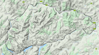
The Culter Hills, Coulter Fells or variations thereof, are a range of hills, part of the Southern Uplands of Scotland. They are neighboured to the east by the Manor Hills and are split roughly in half by the border between South Lanarkshire and the Scottish Borders.

