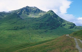
Ben Lui is a mountain in the southern Highlands of Scotland. It is a Munro with a height of 1,130 metres (3,710 ft). Ben Lui is in northeast Argyll and is the highest peak of a mountain chain that includes three other Munros. It has five well-defined ridges radiating out from the summit. Four corries lie between the ridges, including Coirre Gaothaich on the northeast side of the mountain.

Ben Wyvis is a mountain in Easter Ross, in the northern Highlands of Scotland. It lies north-west of Dingwall, in the council area of Highland, and the county of Ross and Cromarty. Ben Wyvis is a large winding and undulating ridge running roughly north–south for about 5 km, the highest point of which is Glas Leathad Mòr at 1,046 metres (3,432 ft). Geologically, the ridge is composed of Moine pelitic gneiss. The mountain is prominent in views of the area, presenting a whale-back shape above the farmland of Strathconon.

Beinn a' Chaorainn is a Scottish mountain in the heart of the Cairngorms range. It is quite a remote hill, being located roughly 19 kilometres south east of Aviemore and 14 kilometres north west of Braemar. The mountain stands on the border of the Moray and Aberdeenshire council areas. The hill's name used to be spelt as Beinn a' Chaoruinn, but the spelling of the word caorunn was altered to caorann by the Gaelic Orthographic Convention's attempts to standardise spelling.

Sgùrr a' Bhealaich Dheirg is a mountain in Kintail on the northern side of Glen Shiel in the Scottish Highlands. With a height of 1,036 metres (3,399 ft), it is classed as a Munro. It is the highest of three Munros known as the "Brothers of Kintail" in contrast to the Five Sisters of Kintail which lie just to the west.

Beinn Dubhchraig is a mountain in the Scottish Highlands, west of Crianlarich in the northern part of Loch Lomond and the Trossachs National Park. It is a Munro with a height of 978 metres (3,209 ft). It is overshadowed by its neighbour Ben Lui, although it is well seen from the main A82 road. Its name means "mountain of the black rock", referring to the steep and rocky face on the southwest slopes above Loch Oss, which offer scrambling routes to the summit.

Beinn Achaladair is a Scottish mountain situated six kilometres north east of the hamlet of Bridge of Orchy. The mountain stands on the border of the Perth and Kinross and Argyll and Bute council areas.

Sròn a’ Choire Ghairbh is a Scottish mountain situated on the northern side of Loch Lochy, 13 kilometres north of Spean Bridge in the Highland Council area.

Beinn a' Chroin is a mountain in the Breadalbane region of the Scottish Highlands, six kilometres south of Crianlarich. With a height of 941 metres (3,087 ft) it qualifies as a Munro.

Cruach Ardrain is a Munro mountain in the Breadalbane region of the Scottish Highlands, with a height of 1,046 metres (3,432 feet). It is five kilometres southeast of Crianlarich village and is one of the Crianlarich Hills.

Beinn Challuim is a mountain in the Breadalbane region of the Scottish Highlands. It is east of the village of Tyndrum, in the Forest of Mamlorn, an ancient deer forest at the northern edge of Loch Lomond and the Trossachs National Park. It is a Munro with a height of 1,025 metres (3,363 ft).

Stob a' Choire Odhair is a Scottish mountain situated eight kilometres north west of Bridge of Orchy on the border of the Argyll and Bute and Highland council areas.

Creise is a mountain summit in the Black Mount range, in the Scottish Highlands. It overlooks the northern end of Glen Etive and its height is 1,100 metres (3,600 ft). Creise is one of four Munros in the Black Mount, along with Meall a' Bhuiridh, Stob Ghabhar and Stob a' Choire Odhair. The mountain is a long and flattish ridge, whose highest point was unnamed until 1981. It is popular with cross-country skiers, being near the White Corries ski area from where it is often climbed along with adjoining Meall a' Bhuiridh. The steep and craggy northern buttress, Sròn na Crèise, is well seen from the A82 road and the Kings House Hotel.

Meall Glas is a mountain situated in the southern highlands of Scotland. It stands on the northern border of the Loch Lomond and the Trossachs National Park, 8.5 kilometres north east of Crianlarich.

Càrn Aosda is a Scottish mountain situated 12.5 km south of the town of Braemar, in the county of Aberdeenshire. It stands near the summit of the Cairnwell Pass on the A93 road, in the midst of the Glenshee Ski Centre.

Càrn Mairg is a mountain in the Breadalbane region of the Scottish Highlands, with a height of 1,042 metres (3,419 ft). It stands in a group of four Munro mountains known as the 'Càrn Mairg group', on the north side of Glen Lyon, Perthshire.

Càrn a' Gheòidh or Càrn Gheòidh is a mountain in the Mounth region of the Scottish Highlands. It lies 15 km south of the town of Braemar. Its summit stands on the border between the council areas of Perth and Kinross and Aberdeenshire.

Stob Choire Claurigh is a mountain in Lochaber in the Scottish Highlands, with a height of 1,177 metres (3,862 ft). It is part of the Grey Corries, near Ben Nevis, and lies about 16 km (10 mi) east of Fort William. It is described as one of the best ridge walks on the Scottish mainland.

Chno Dearg is a mountain in the Lochaber area of the Scottish Highlands. It overlooks Glen Spean to the north and Loch Treig to the west. With a height of 1,046 metres (3,432 ft), it is classed as a Munro.
Glas Tulaichean is a large, complex mountain in the Mounth, Scotland. It is about 18 kilometres (11 mi) south of Braemar in Perth and Kinross. It is the highest of a group of domed hills which lie in remote land between the head of Glen Tilt and Glen Shee to the east. It is most commonly climbed from the Spittal of Glenshee via Glen Lochsie to the south.

Beinn Mheadhoin or Beinn Meadhain is a mountain in the Highlands of Scotland. It is a Munro with a height of 1,182 metres (3,878 ft) and by some counts it is the twelfth-highest mountain of Great Britain. It lies in the very heart of the Cairngorm mountains, and is one of the most remote in the region. Beinn Mheadoin is surrounded by deep glens and mountain lakes, including Loch A'an, Loch Etchachan and the Dubh Lochan.


