
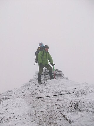
Sgùrr Mòr is the highest of the nine Munros in the mountain range known as the Fannichs in northern Scotland. This range is located between Loch Fannich and the A835 Ullapool road — a remote area with few habitations, but these Munros, which are usually climbed in groups or occasionally in a single hike, are mostly gentle sloped and fairly accessible from either of these locations. If approached from Loch Fannich, a bicycle or permission to drive on the private road would be helpful.

Ben Cruachan is a mountain that rises to 1,126 metres (3,694 ft), the highest in Argyll and Bute, Scotland. It gives its name to the Cruachan Dam, a pumped-storage hydroelectric power station located in a cavern inside the mountain. It is the high point of a ring of mountains, known as the Cruachan Horseshoe, that surrounds the power station reservoir. The horseshoe includes a further Munro, a Corbett, and several subsidiary summits. "Cruachan!" is the battle cry of Highland clans Campbell and MacIntyre.

Ben Avon is a mountain in the Cairngorms of Scotland. It is a sprawling mountain with a broad summit plateau dotted with granite tors. One of these marks the summit, called Leabaidh an Daimh Bhuidhe or Stob Easaidh Mòr, which stands at a height of 1,171 metres (3,842 ft). It is classified as both a Munro and a Marilyn.

Meall a' Bhùiridh (IPA:[ˈmauɫ̪ˈaˈvuːɾʲɪʝ]) is a mountain on the edge of Rannoch Moor in the Highlands of Scotland. It lies near the top of Glen Coe and Glen Etive, overlooking the Kings House Hotel inn and the A82 road. The Glencoe Ski area is located on the northern slopes of the peak.
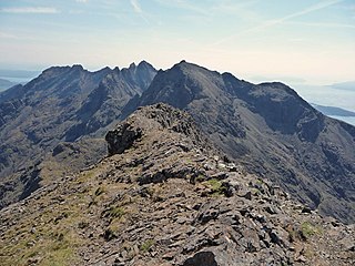
Sgùrr na Banachdaich, also spelt Sgurr na Banachdich in English, is a peak in the Cuillin mountains on the Isle of Skye, Scotland. It reaches a height of 965 metres (3,166 ft), making it a Munro; standing at the western edge of the Cuillin ridge, it is the most westerly of the Munros.
Sgùrr a' Mhadaidh is a mountain peak in the Black Cuillin range on the Isle of Skye, Scotland. It is a Munro with a height of 918 metres (3,012 ft). Like the rest of the range it is composed of gabbro, a rock with excellent grip for mountaineering.

Binnein Mòr is the highest peak in the Mamores, the range of mountains between Glen Nevis and Loch Leven in the Highlands of Scotland, located about five kilometres north-northeast of Kinlochleven. The pyramidal summit of Binnein Mòr lies above the uninhabited upper section of Glen Nevis, north of the main Mamores ridge. To the south, a short narrow ridge links to the main ridge at an unnamed 1062 m subsidiary top listed in Munro's Tables as Binnein Mòr south top. Binnein Mòr's second subsidiary top, Sgòr Eilde Beag (956 m), lies about a kilometre to the southeast and forms the eastern end of the main Mamores ridge.
Sgùrr Eilde Mòr or Sgùrr Èilde Mhòr is a mountain in the Mamores range of the Grampian Mountains, Scotland. It is 6 kilometres north-east of Kinlochleven. It is a steep, conical peak of scree and quartzite boulders, capped with a layer of schist. With a height of 1010 m (3314 ft) it is classed as a Munro, so is popular with hillwalkers. It is most commonly climbed from Kinlochleven by way of a stalker's path which leads to a col at Coire an Lochan, and then by either the south or the west ridge - both routes involving an ascent of steep, bouldery terrain.

Ben Chonzie or Ben-y-Hone is a mountain in the Breadalbane region of the Scottish Highlands. It is eleven kilometres northwest of Crieff. It stands at 931 metres (3,054 ft) and is therefore listed as a Munro. It is the highest point of a large area of moorland and rounded hills between Loch Earn and Loch Tay, and with a broad, flat summit and relatively few distinguishing features, it is often regarded as one of Scotland's least interesting Munros.

Ben Klibreck is a Scottish mountain located in central Sutherland. It is an isolated mountain, rising above a large area of moorland. The highest point, Meall nan Con, rises to 962 metres (3,156 ft) elevation and is therefore the second most northerly Munro after Ben Hope. The western side of the hill is a fairly uniform steep, heathery slope, while the eastern side has a series of large, grassy corries and has been described as having more character.

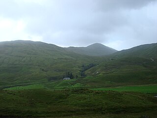
Fionn Bheinn is a mountain located south of Loch Fannich in the northwestern Scottish Highlands. It has a height of 933 m (3061 ft) and is listed as a Munro. The south side of the mountain is a shallow, smooth grassy slope, but its north face is steeper and is considered more impressive.

Gleouraich is a Scottish mountain located to the north of Loch Quoich in the northwestern highlands. It has a height of 1035 m (3396 ft) and is classed as a Munro. The mountain's main aspects contrast with each other; the south side of the mountain is a gentle, grassy slope, but its north face is steep, dark rock, with a complex array of ridges and corries.

Beinn Sgulaird or Beinn Sguiliaird is a mountain in the Lorn region of the Scottish Highlands, between Glen Creran and Glen Etive. It has a height of 937 m (3074 ft) and is classed as a Munro. The mountain takes the form of a long ridge which runs from southwest to northeast, three kilometres of which lie above 800 m. Hillwalkers commonly traverse the ridge from north to south, as this gives the best views of the Hebrides to the west, in particular the Isle of Mull. While most walkers start from Glen Creran to the west, an ascent from Glen Etive is also possible.

Beinn a' Chreachain is a Scottish mountain, with a conical top, to the north-west of Loch Lyon.

Beinn Heasgarnich is a mountain in the Breadalbane region of the Scottish Highlands. It lies about 2 km south of Loch Lyon. It is a Munro with a height of 1,078 metres (3,537 ft).

Beinn Bhuidhe is a mountain near the head of Loch Fyne in Argyll in the Scottish Highlands. It is a Munro with a height of 948 metres (3,110 ft).
Beinn Tulaichean is a Scottish mountain. It is not much more than the southern top of Cruach Ardrain, with a descent of only 120m before the ascent to its larger neighbour. It is located approximately 10 km to the north of Loch Katrine close to the site of Robert Roy MacGregor's house.
Beinn Chabhair is a Scottish mountain. It has fine views down to Loch Lomond.
Sgiath Chùil is a mountain situated in the southern highlands of Scotland. It stands within Loch Lomond and the Trossachs National Park, on its northern border. It is about 11 kilometres (6.8 mi) west of Killin.
Stob Coire an Laoigh is a Scottish mountain in The Grey Corries Range, 15 kilometres north east of Kinlochleven.


