
The Cairngorm Mountain Railway, which opened in 2001, is the highest railway in the United Kingdom. The two-kilometre long funicular ascends the northern slopes of Cairn Gorm, the United Kingdom's sixth-highest mountain, serving the Cairngorm Mountain ski resort. The route and ski area are located within the Cairngorms National Park, the largest National Nature Reserve in Britain, located near Aviemore in the Highland area of Scotland. It is a Doppelmayr 120-SSB funicular railway.

The Cairngorms are a mountain range in the eastern Highlands of Scotland closely associated with the mountain Cairn Gorm. The Cairngorms became part of Scotland's second national park on 1 September 2003. Although the Cairngorms give their name to, and are at the heart of, the Cairngorms National Park, they only form one part of the national park, alongside other hill ranges such as the Angus Glens and the Monadhliath, and lower areas like Strathspey.

The Grampian Mountains is one of the three major mountain ranges in Scotland, that together occupy about half of Scotland. The other two ranges are the Northwest Highlands and the Southern Uplands. The Grampian range extends northeast to southwest between the Highland Boundary Fault and the Great Glen. The range includes many of the highest mountains in the British Isles, including Ben Nevis and Ben Macdui.

Cairn Gorm is a mountain in the Scottish Highlands. It is part of the Cairngorms range and wider Grampian Mountains. With a summit elevation of 1,244.8 m (4,084 ft) above sea level, Cairn Gorm is classed as a Munro and is the sixth-highest mountain in the British Isles. The high, broad domed summit overlooking Strathspey is one of the most readily identifiable mountains from the nearby town and regional centre of Aviemore. Although it shares its name with the Cairngorm mountains, Ben Macdui is the highest mountain in the range.

Ben More is a mountain in the Breadalbane region of the southern Scottish Highlands, near Crianlarich. Rising to 1,174 metres (3,852 ft), it is a Munro and is the highest of the so-called Crianlarich Hills to the south-east of the village. There is no higher land in the British Isles south of Ben More. It is separated from Stob Binnein by the Bealach-eadar-dha Beinn, "col between two mountains". It is the highest peak in the Loch Lomond and The Trossachs National Park.

The Ochil Hills is a range of hills in Scotland north of the Forth valley bordered by the cities of Stirling, Perth and the towns of Alloa, Kinross, and Auchterarder. The only major roads crossing the hills pass through Glen Devon/Glen Eagles and Glenfarg, the latter now largely replaced except for local traffic by the M90 Edinburgh-Perth motorway cutting through the eastern foothills. The hills are part of a Devonian lava extrusion whose appearance today is largely due to the Ochil Fault which results in the southern face of the hills forming an escarpment. The plateau is undulating with no prominent peak, the highest point being Ben Cleuch at 721 m (2,365 ft). The south-flowing burns have cut deep ravines including Dollar Glen, Silver Glen and Alva Glen, often only passable with the aid of wooden walkways.

Cairn Toul is the 4th-highest mountain in Scotland and all of the British Isles, after Ben Nevis, Ben Macdui and Braeriach. The summit is 1,291 metres above sea level. It is in the western massif of the Cairngorms, linked by a bealach at about 1125 m to Braeriach. The mountain towers above the Lairig Ghru pass.

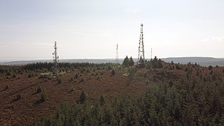
The Cairn o' Mount or Cairn o' Mounth is a hill in Aberdeenshire, Scotland, rising to 455 metres (1,493 ft). The B974 road crosses its summit, connecting the Howe of the Mearns with Deeside.

Sgòr an Lochain Uaine is one of the Cairngorms mountains in the Scottish Highlands. Rising to 1,258 metres (4,127 ft), by some counts it is the fifth-highest mountain in Scotland. It is in the western massif of the Cairngorms, standing between Braeriach and Cairn Toul, overlooking An Garbh Choire and the Lairig Ghru pass. It was promoted to Munro status by the Scottish Mountaineering Club's 1997 revision of the tables.

Scotland is the most mountainous country in the United Kingdom. Scotland's mountain ranges can be divided in a roughly north to south direction into: the Scottish Highlands, the Central Belt and the Southern Uplands, the latter two primarily belonging to the Scottish Lowlands. The highlands eponymously contains the country's main mountain ranges, but hills and mountains are to be found south of these as well. The below lists are not exhaustive; there are countless subranges throughout the country.

Glas Maol is a mountain in the Mounth, in the southeastern part of the Highlands of Scotland. The broad, flat summit is divided between the council area of Aberdeenshire, Angus and Perth and Kinross, though the highest point lies wholly within Angus; indeed Glas Maol is the highest point in that council area. Glas Maol is both a Munro and a Marilyn. The western slopes of Glas Maol form part of the Glenshee Ski Centre ski area. The most common route of ascent goes through the slopes, starting from the highest point of the A93 road, the Cairnwell pass. This is the highest public road in Scotland; hence only around 400 m of ascent is involved. Glas Maol is often climbed in conjunction with Creag Leacach to the south or Cairn of Claise to the north. The broad ridge linking these peaks is topped by a dry-stone dyke, which approximately corresponds to the border of the Angus council area.

Mount Keen is a 939-metre-high (3,081 ft) mountain in Scotland and the most easterly Munro. It can be accessed from several directions, South from Glen Mark, North from Glen Tanar, and East to Braid Cairn. It is a moderate walk which is most popularly started by mountain bike, riding through the native Caledonian pine forest of Glen Tanar from Aboyne. On a good day, the Cairngorms, especially Lochnagar, can be seen. The summit is marked by a trig point.
Cairn Mon Earn or Cairn-mon-earn is a hill in Aberdeenshire, Scotland.

The Kilpatrick Hills are a range of hills in central Scotland, stretching from Dumbarton in the west to Strathblane in the east.

Blackhammer Chambered Cairn is a Neolithic chambered cairn located on the island of Rousay, in Orkney, Scotland. The tomb, constructed around 3000 BC, is a Orkney–Cromarty chambered cairn, characterized by stalled burial compartments. Historic Environment Scotland established the site as a scheduled monument in 1994.

Broad Cairn is a mountain in the Grampians of Scotland, located about 16 mi (26 km) south of the River Dee near Balmoral.

Beinn Mheadhoin or Beinn Meadhain is a mountain in the Highlands of Scotland. It is a Munro with a height of 1,182 metres (3,878 ft) and by some counts it is the twelfth-highest mountain of Great Britain. It lies in the very heart of the Cairngorm mountains, and is one of the most remote in the region. Beinn Mheadoin is surrounded by deep glens and mountain lakes, including Loch A'an, Loch Etchachan and the Dubh Lochan.
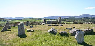
Tomnaverie stone circle is a recumbent stone circle set on the top of a small hill in lowland northeast Scotland. Construction started from about 2500 BC, in the Bronze Age, to produce a monument of thirteen granite stones including a massive 6.5-ton recumbent stone lying on its side along the southwest of the circle's perimeter. Within the 17-metre (56 ft) circle are kerb stones encircling a low 15-metre (49 ft) ring cairn but the cairn itself no longer exists.

Knowe of Yarso chambered cairn is a Neolithic burial monument located on the island of Rousay in Orkney, Scotland. The site was excavated in the 1930s, and uncovered human and animal bones as well as pottery sherds, flint and bone tools, and arrowheads. The tomb, dating to the period between 3500 and 2500 BC, is a stalled chambered cairn, similar to Midhowe and Blackhammer. Historic Environment Scotland established the site as a scheduled monument in 1994.

