
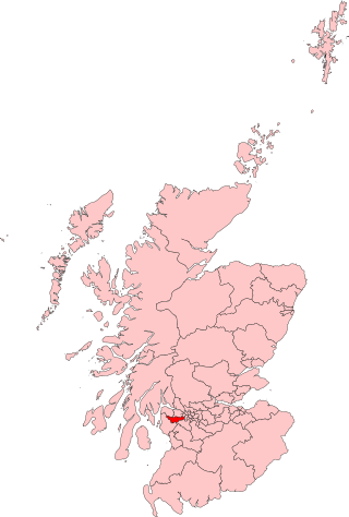
Inverclyde is one of 32 council areas used for local government in Scotland. Together with the East Renfrewshire and Renfrewshire council areas, Inverclyde forms part of the historic county of Renfrewshire, which currently exists as a registration county and lieutenancy area. Inverclyde is located in the west central Lowlands. It borders the North Ayrshire and Renfrewshire council areas, and is otherwise surrounded by the Firth of Clyde.

Renfrewshire is one of the 32 council areas of Scotland.

Port Glasgow is the second-largest town in the Inverclyde council area of Scotland. The population according to the 1991 census for Port Glasgow was 19,426 persons and in the 2001 census was 16,617 persons. The most recent census in 2011 states that the population has declined to 15,414. It is located immediately to the east of Greenock and was previously a burgh in the county of Renfrewshire.

Bridge of Weir is a village within the Renfrewshire council area and wider historic county of Renfrewshire in the west central Lowlands of Scotland.

Lochwinnoch is a village in the council area and historic county of Renfrewshire in the west central Lowlands of Scotland. Lying on the banks of Castle Semple Loch and the River Calder, Lochwinnoch is chiefly a residential dormitory village serving nearby urban centres such as Glasgow and Paisley. Its population in 2001 was 2628.

Bishopton (/bɪʃəptən/) is a village in Renfrewshire, Scotland. It is located around 2 miles (3 km) west of Erskine.

Netherlee is a suburban residential area in East Renfrewshire, Scotland. It is situated on the west bank of the White Cart Water about 4 miles (6.5 km) south of Glasgow city centre. Part of the Greater Glasgow conurbation, it is mostly contiguous with the city, and is just beyond the boundary of its local authority area. It is a separate census locality from Glasgow, like other areas such as neighbouring Giffnock and Clarkston. Netherlee is directly contiguous with Stamperland. It is also in a council ward with Clarkston and its neighbour Busby. As of 2012, Netherlee has a population of 4,550.

Inverclyde is a parliamentary constituency of the House of Commons of the Parliament of the United Kingdom. It replaced Greenock and Inverclyde and the Port Glasgow and Kilmacolm areas from West Renfrewshire for the 2005 general election.
Paisley and Renfrewshire South is a constituency of the House of Commons, located in Renfrewshire, Scotland to the southwest of Glasgow. It elects one Member of Parliament at least once every five years using the first-past-the-post system of voting.
Kilbirnie is a small town of 7,280 inhabitants situated in the Garnock Valley area of North Ayrshire, on the west coast of Scotland. It is around 20 miles (30 km) southwest of Glasgow and approximately 10 miles from Paisley and 13 miles from Irvine respectively. Historically, the town's main industries were flax production and weaving before iron and steelmaking took over in the 19th and early 20th centuries. The suburb of Kilbirnie in the New Zealand capital of Wellington is named after the town.

Castle Semple Loch is a 1.5-mile-long (2.5 km) inland freshwater loch at Lochwinnoch in Renfrewshire, Scotland. Originally part of an estate of the same name, it is now administered by Clyde Muirshiel Regional Park as a watersports centre. An RSPB bird sanctuary is located on the loch's southern shore.

Inverkip is a village and parish in the Inverclyde council area and historic county of Renfrewshire in the west central Lowlands of Scotland, 5 miles (8 km) southwest of Greenock and 8.1 miles (13 km) north of Largs on the A78 trunk road. The village takes its name from the River Kip and is served by Inverkip railway station.
Kilmacolm is a village and civil parish in the Inverclyde council area, and the historic county of Renfrewshire in the west central Lowlands of Scotland. It lies on the northern slope of the Gryffe Valley, 7+1⁄2 miles southeast of Greenock and around 15 miles (24 km) west of the city of Glasgow. The village has a population of around 4,000 and is part of a wider civil parish which covers a large rural hinterland of 15,000 hectares containing within it the smaller settlement of Quarrier's Village, originally established as a 19th-century residential orphans' home.

Strathgryffe or Gryffe Valley is the strath of River Gryffe, which lies within the historic county of Renfrewshire in the west central Lowlands of Scotland.

Clyde Muirshiel Regional Park is the collective name for areas of countryside set aside for conservation and recreation on the South Clyde estuary in Scotland.
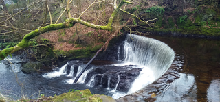
The River Calder is a river mainly within Renfrewshire, Scotland.
The Duchal Moor Railway was a 2 ft narrow-gauge railway built in the 1920s to carry shooting parties to the grouse moors of Duchal Moor and the Muirshiel Hills, within the Clyde Muirshiel Regional Park, 3 miles (5 km) west-southwest of Kilmacolm in Scotland. It closed in the late 1970s.
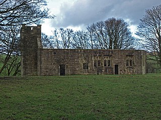
Castle Semple Collegiate Church is located in Renfrewshire, Scotland. It is situated near the eastern end of Castle Semple Loch, within Clyde Muirshiel Regional Park, and 2 miles (3.2 km) west of Howwood on the B787, then on to the B776. The late Gothic church is under the protection of Historic Environment Scotland as a Scheduled monument.

Windy Hill is a 316 metres (1.037 feet) high hill in Renfrewshire, Scotland. It is one of the TuMPs of the Lowlands.
The regional parks of Scotland are areas of attractive countryside that are of importance for recreation due to their proximity to population centres. The parks are defined to co-ordinate the management of these areas by providing visitor facilities such as car parks, footpaths, ranger services and visitor centres.

