
Perthshire, officially the County of Perth, is a historic county and registration county in central Scotland. Geographically it extends from Strathmore in the east, to the Pass of Drumochter in the north, Rannoch Moor and Ben Lui in the west, and Aberfoyle in the south; it borders the counties of Inverness-shire and Aberdeenshire to the north, Angus to the east, Fife, Kinross-shire, Clackmannanshire, Stirlingshire and Dunbartonshire to the south and Argyllshire to the west. It was a local government county from 1890 to 1930.

Clackmannanshire is a historic county, council area, registration county and Lieutenancy area in Scotland, bordering the council areas of Stirling, Fife, and Perth & Kinross and the historic counties of Perthshire, Stirlingshire and Fife.

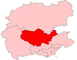
Perth and Kinross is one of the 32 council areas of Scotland and a Lieutenancy Area. It borders onto the Aberdeenshire, Angus, Argyll and Bute, Clackmannanshire, Dundee, Fife, Highland and Stirling council areas. Perth is the administrative centre. With the exception of a large area of south-western Perthshire, the council area mostly corresponds to the historic counties of Perthshire and Kinross-shire.

The M90 is a motorway in Scotland, UK. It runs from Junction 1A of the M9 motorway, south of the Queensferry Crossing, to Perth. The motorway passes by the Scottish towns of Dunfermline and Kinross. The M90 is the northernmost motorway in the United Kingdom. The northern point spurs into the western suburbs of Perth at Broxden. A small part of the M90 was originally numbered as the M85 motorway.

Auchterarder is a small town located north of the Ochil Hills in Perth and Kinross, Scotland, and home to the Gleneagles Hotel. The 1+1⁄2-mile-long (2.5-kilometre) High Street of Auchterarder gave the town its popular name of "The Lang Toun" or Long Town.

The County of Kinross or Kinross-shire is a historic county and registration county in eastern Scotland, administered as part of Perth and Kinross since 1930. Surrounding its largest settlement and county town of Kinross, the county borders Perthshire to the north and Fife to the east, south and west.

Milnathort is a small town in the parish of Orwell in the county of Kinross-shire, Scotland and since 1996, the local council area of Perth and Kinross. The smaller neighbour of nearby Kinross, Milnathort has a population of around 2,000 people. It is situated amidst countryside at the foot of the Ochil Hills, and near the north shore of Loch Leven. From 1977 it became more easily accessible due to the development of the M90 motorway. The name comes from the Gaelic maol coirthe meaning "bare hill of the standing stones".

Abernethy is a village in Perth and Kinross, Scotland, situated 8 miles (13 km) south-east of Perth.

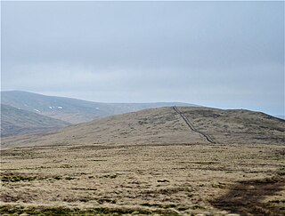
The Ochil Hills (; Scottish Gaelic: Monadh Ochail is a range of hills in Scotland north of the Forth valley bordered by the towns of Stirling, Alloa, Kinross, Auchterarder and Perth. The only major roads crossing the hills pass through Glen Devon/Glen Eagles and Glenfarg, the latter now largely replaced except for local traffic by the M90 Edinburgh-Perth motorway cutting through the eastern foothills. The hills are part of a Devonian lava extrusion whose appearance today is largely due to the Ochil Fault which results in the southern face of the hills forming an escarpment. The plateau is undulating with no prominent peak, the highest point being Ben Cleuch at 721 m. The south-flowing burns have cut deep ravines including Dollar Glen, Silver Glen and Alva Glen, often only passable with the aid of wooden walkways.

Glen Eagles is a glen which connects with Glen Devon to form a pass through the Ochil Hills of Perth and Kinross in Scotland.

Ochil and South Perthshire is a county constituency of the House of Commons of the Parliament of the United Kingdom. It elects one Member of Parliament (MP) by the first-past-the-post system of election.

Perth and North Perthshire is a county constituency of the House of Commons of the Parliament of the United Kingdom. It elects one Member of Parliament (MP) by the first past the post system of election. The seat was created in 2005. The seat is statistically, in local percentage terms, the second-closest result of the 2017 contests nationwide.

Abbots Deuglie is a hamlet in Perth and Kinross, Scotland. It is located in the Ochil Hills, in Arngask parish, about one mile (1.5 km) west of Glenfarg. Glenfarg Reservoir lies just to the west of the village, and was built in 1912.

Angus was a constituency of the Scottish Parliament (Holyrood). It elected one Member of the Scottish Parliament (MSP) by the first past the post method of election. Also, however, it was one of nine constituencies in the North East Scotland electoral region, which elects seven additional members, in addition to nine constituency MSPs, to produce a form of proportional representation for the region as a whole.
Perth was a constituency of the Scottish Parliament (Holyrood). It elected one Member of the Scottish Parliament (MSP) by the plurality method of election. Also, however, it was one of nine constituencies in the Mid Scotland and Fife electoral region, which still elects seven additional members, in addition to nine constituency MSPs, to produce a form of proportional representation for the region as a whole.

Ochil was a county constituency of the House of Commons of the Parliament of the United Kingdom from 1997 until 2005. It elected one Member of Parliament (MP by the first-past-the-post voting system.

Portmoak is a parish in Kinross-shire, Scotland. It consists of a group of settlements running north to south: Glenlomond, Wester Balgedie, Easter Balgedie, Kinnesswood, Kilmagadwood and Scotlandwell.
Lendrick Muir School was a Scottish residential school for maladjusted children of above average intelligence, aged 11–19 or latterly children with dyslexia, located in Perth and Kinross on an unclassified road from Rumbling Bridge to Crook of Devon.
Strathdevon is the strath of the River Devon in Clackmannanshire, Scotland. Strathdevon is associated with the parish of Muckhart and was up until 1971 the southernmost tip of Perthshire.
Tarmangie Hill is a hill in the Ochil Hills range, part of the Central Lowlands in Scotland. It is one of two Ochil Donalds to lie on the Clackmannanshire-Perth and Kinross border - the other being Blairdenon Hill. It is often climbed as part of a round from Glen Sherup.
