
Peatrig Hill is a minor hill in Scotland, located about 15 km south-southeast of Edinburgh. One of the Moorfoot Hills, it is located in the parish of Heriot in the Scottish Borders Council Area.

Midlothian is a historic county, registration county, lieutenancy area and one of 32 council areas of Scotland used for local government. Midlothian lies in the east-central Lowlands, bordering the City of Edinburgh, East Lothian and the Scottish Borders.
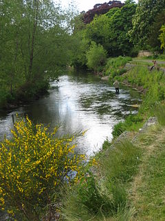
The River Esk, also called the Lothian Esk, is a river that flows through Midlothian and East Lothian, Scotland.
Leithen Water is a tributary of the River Tweed in Scotland. It rises in the Moorfoot Hills and joins the Tweed near the town of Innerleithen, whose name comes from the Scottish Gaelic inbhir, meaning a confluence, and anglicised as "inner" or "inver". The Brythonic equivalent is "Aber". "Leithen" is a Celtic name meaning grey in colour.
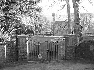
Heriot is a small village in the Moorfoot Hills southeast of Edinburgh, Scotland, within Eildon. The village comprises some 150 dwellings, spread over a geographical area of around 50 square miles (130 km2), most of which is moorland. Connected to the rest of the world primarily through the A7 road, Heriot had a railway station from 1849 until the branch line closures instigated by Beeching caused the track to be uplifted in the 1960s. The Scottish Parliament voted, in 2006, to reinstate the railway, but without a station at Heriot.

Gladhouse Reservoir, formerly known as Moorfoot Loch, is a reservoir in Midlothian, Scotland, five miles (8 km) south of Penicuik. It is the most southerly reservoir in Midlothian, as well as being the largest area of freshwater in the Lothians. It is used to supply Edinburgh with drinking water.

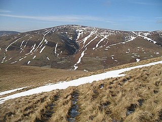
The Moorfoot Hills are a range of hills south of Edinburgh in east central Scotland, one of the ranges which collectively form the Southern Uplands.

Luinne Bheinn is a mountain in the Northwest Highlands of Scotland, on the Knoydart Peninsula in Lochaber.

Beinn Dearg Mhor, is a mountain in the Red Cuillin mountains of the Isle of Skye. It is located between Loch Ainort and the settlement of Sligachan.

Hart Fell is a hill in the Moffat Hills range, part of the Southern Uplands of Scotland. It lies north of the town of Moffat on the border with the Scottish Borders and Dumfries and Galloway.

Dun Rig is a hill in the Manor Hills range, part of the Southern Uplands of Scotland. It is the highest hill in the northernmost cluster of the Manor Hills, south of the town of Peebles in the Scottish Borders. A sprawling summit, it is usually climbed as part of the Dun Rig Horseshoe from the Peebles side and provides great views into the Moorfoot Hills, Pentlands, rest of the Manor Hills and the central Borders. It is the historic county top of the former county of Selkirkshire.

Windy Standard is a hill in the Carsphairn and Scaur Hills range, part of the Southern Uplands of Scotland. It lies in Dumfries and Galloway, south of the town of New Cumnock. Once a remote hill to the northeast of Cairnsmore of Carsphairn, its summit area and slopes are now home to a series of expanding large windfarm sites, the earliest of which used to be the largest windfarm in Scotland.

Ettrick Pen is a hill in the Ettrick Hills range, part of the Southern Uplands of Scotland. A remote peak, It lies southwest of the village of Ettrick, on the border of the Scottish Borders and Dumfries and Galloway. The highest of the Ettrick Hills, it is crossed by the Southern Upland Way and is a prominent landmark from many directions. Its summit is topped by an ancient cairn.

Windlestraw Law is a hill in the Moorfoot Hills range, part of the Southern Uplands of Scotland. It is the highest peak of the range, and lies north of the town of Innerleithen in the Scottish Borders. A large and boggy peak, it is usually climbed from either its western slopes or the longer route from Tweeddale to the south.

Millfore is a hill in the Minnigaff Hills, a sub-range of the Galloway Hills range, part of the Southern Uplands of Scotland. It lies northeast of Newton Stewart in Galloway Forest Park, Dumfries and Galloway. One of the less-visited of the Galloway Hills, it nonetheless provides excellent views from its summit over its neighbours and Loch Dee. Isolated from its westerly neighbours by the White Laggan glen, it is frequently climbed on its own from Clatteringshaws Loch to the east.

Bowbeat Hill is a hill in the Moorfoot Hills range, part of the Southern Uplands of Scotland. It lends its name to Bowbeat Onshore Wind Farm built on the hill and commissioned in 2003. The wind farm produces 31.2MW of power using 24 turbines. It is commonly ascended with its neighbouring hills from Gladhouse Reservoir to the north.
Whitehope Law is a hill in the Moorfoot Hills range, part of the Southern Uplands of Scotland. A relatively isolated hill, it is frequently climbed on its own from the B709 road to its south and east. A farm to the south lends its name to the hill.

Dundreich is a hill in the Moorfoot Hills range, part of the Southern Uplands of Scotland. Its close proximity to Edinburgh allows for an almost unimpeded view towards the city, as well as into the Pentland Hills and surrounding counties. Tied with Whitehope Law as the lowest Moorfoot Donald, it is most frequently climbed from the Gladhouse Reservoir to the north, often as part of a round of the neighbouring hills.
