| Merrick | |
|---|---|
 | |
| Highest point | |
| Elevation | 843 m (2,766 ft) [1] |
| Prominence | 705 m [1] |
| Listing | Ma,Hu,Tu,Sim, C, D,CoH,CoU, CoA,DN,Y,T100,P600,P500 [2] |
| Coordinates | 55°08′21″N4°28′06″W / 55.1393°N 4.4684°W |
| Geography | |
 Merrick | |
| Parent range | Range of the Awful Hand, Southern Uplands |
| OS grid | NX 42760 85547 |
| Topo map | OS Landranger 77 |
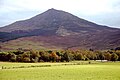
The Merrick (from Gaelic meurag, "fingered, knucked") [3] is a mountain in the Range of the Awful Hand, a sub-range of the Galloway Hills range, part of the Southern Uplands of Scotland. The summit elevation is 843 metres (2,766 feet), making it the highest mountain in the Southern Uplands and southern Scotland.


