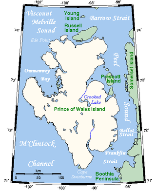
Prince of Wales Island is an Arctic island in Nunavut, Canada. One of the larger members of the Arctic Archipelago, it lies between Victoria Island and Somerset Island and is south of the Queen Elizabeth Islands.
Moidart is part of the remote and isolated area of Scotland, west of Fort William, known as the Rough Bounds. Moidart itself is almost surrounded by bodies of water. Loch Shiel cuts off the eastern boundary of the district and continues along part of the southern edge. The remainder of the southern edge is cut off by Loch Moidart. The north is cut off by Loch Morar and Loch Ailort.

Sunart is a rural district and community in the south west of Lochaber in Highland, Scotland, on the shores of Loch Sunart, and part of the civil parish of Ardnamurchan. The main village is Strontian, at the head of the loch, which is the location of Ardnamurchan High School, the local fire station, police station and other facilities.

Àrd Bheinn is a mountain on the Isle of Arran in western Scotland. It has an elevation of 512 m (1,680 ft) and a prominence of 143.8 m (472 ft) and is classed as a Dodd and a Highland Five.

Gaor Bheinn, also known in English as Gulvain, is a mountain in the Northwest Highlands of Scotland. It is in Lochaber, south of Loch Arkaig and north of the road west of Fort William. It is composed of banded granite and shaped like a letter Y, with two tops connected by a ridge running from northeast to southwest, with the northern top 6 m higher than the one to the south. Crags drop at either end, and steep slopes fall away to either side. The south ridge path is really a stream bed, so in wet conditions an easier if longer ascent from Na Socachan is to walk up Allt a Choire Reidh towards Gualann nan Osna and climb the south top's north-west ridge.

Loch Ailort is a sea loch in Morar, Lochaber, Highland, Scotland. Loch Ailort is a shallow, V-shaped loch, with the small Ardnish Peninsula on the north side, and the large, southwest-facing Moidart Peninsula to the south. Loch Ailort is bounded in the northeast by the settlement of the same name, Lochailort and in the west, opening out into the Sound of Arisaig. To the north of the loch lies Loch nan Uamh.

Morrone is a Scottish hill immediately southwest of the village of Braemar in Aberdeenshire.
Eilean Shona is a tidal island situated at the entrance of Loch Moidart, on the west coast of Scotland, just north of the Ardnamurchan Peninsula. The island is 525 hectares in area, with the highest point being Beinn a' Bhàillidh at 265 metres (869 ft). There are five other peaks of over 150 metres (490 ft) and views of the sea and off-shore islands including Rhum, Eigg and Skye. It is reached by a short boat ride from the mainland. The modern name may be from the Old Norse for "sea island". The pre-Norse Gaelic name, as recorded by Adomnán was Airthrago or Arthràigh, meaning 'foreshore island', similar to the derivation of Erraid.

Fionn Bheinn is a mountain located south of Loch Fannich in the northwestern Scottish Highlands. It has a height of 933 m (3061 ft) and is listed as a Munro. The south side of the mountain is a shallow, smooth grassy slope, but its north face is steeper and is considered more impressive.
Garmoran is an area of western Scotland. It lies at the south-western edge of the present Highland Region. It includes Knoydart, Morar, Moidart, Ardnamurchan, and the Small Isles.

The A861 road is a circuitous, primarily coastal, road in Lochaber, within the Highland council area of Scotland.

Clach Bheinn is a hill in Scotland near Lochgoilhead in the Ardgoil Peninsula and is within the Arrochar Alps. The hill reaches a height of 441 m (1,447 ft) and has a prominence of 348 m (1,142 ft).

Loch Moidart is a sea loch in the district of Moidart in the Scottish Highlands. It is on the west coast of Scotland, and runs about 8 km eastward from the sea. It is connected to the sea by two narrow channels which are separated by the island of Eilean Shona, which in turn is nearly split in two by a narrow isthmus. The River Moidart enters the loch at its head, near the hamlet of Ardmolich. Various views of the loch have featured as an Apple TV screensaver since 2021.
Beinn Odhar Bheag is a mountain in the Northwest Highlands of Scotland, south of the village of Glenfinnan in Moidart, Lochaber. It shares the distinction of being the highest point in Moidart with Rois-bheinn, whose summit has the same elevation.

An Stac is the name of a 814 m mountain in the Northwest Highlands, Scotland, on the shore of Loch Ailort on the west coast of Lochaber. A steep-sided conical peak, the mountain is usually climbed in conjunction with its higher neighbour Rois-bheinn. The nearest settlement is the hamlet of Lochailort.
Creach Bheinn is a prominent mountain in the Morvern area in the west of Scotland. It is less steep and even less frequently climbed than its northern neighbour, Garbh Bheinn, but the views to the south and west to the islands are open and extensive.

Garbh Bheinn is a mountain in Scotland. Its name is Scots Gaelic for "rough mountain".

Glas Bheinn (792 m) is a mountain in the Grampian Mountains of Scotland, northeast of the village of Kinlochleven in Lochaber.

Creach Bheinn is a mountain in the Grampian Mountains of Scotland. It rises above the head Loch Creran in Argyll.

Clach Bheinn is a mountain in Scotland, on the Cowal peninsula, west of Loch Eck. It has an elevation of 643 m (2,110 ft) and a prominence of 128 m (420 ft) and is classed as a Simm, a Yeaman (hill) and a Graham Top. Its parent peak is Beinn Mhòr, which lies 1.8 mi (2.9 km) to its north west.


