Aran Fawddwy

Last updated

Aran Fawddwy
Aran Fawddwy.jpg
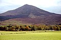
Aran Fawddwy (on left) and Creiglyn Dyfi
Highest point
Elevation 905.6 m (2,971 ft) [1]
Prominence 671 m (2,201 ft)
Parent peak Snowdon   OOjs UI icon edit-ltr-progressive.svg
Listing Marilyn, Hewitt, Nuttall
Coordinates 52°47′16.35″N3°41′18.10″W / 52.7878750°N 3.6883611°W / 52.7878750; -3.6883611
Naming
English translationMawddwy peak[ citation needed ]
Language of name Welsh
PronunciationWelsh: [ˈaranˈvau̯ðʊɨ̯]
Geography
Wales relief location map.jpg
Red triangle with thick white border.svg
Aran Fawddwy
Parent range Snowdonia
OS grid SH862223
Topo map OS Landranger 124, 125
Listed summits of Aran Fawddwy
NameGrid refHeightStatus
Aran Benllyn SH866243 885 m (2,904 ft) H, N
Erw y Ddafad-ddu SH864234 872 m (2,861 ft) H, N
Foel Hafod-fynydd SH876227 689 m (2,260 ft) H, N
Gwaun y Llwyni SH857204 685 m (2,247 ft) H, N
Gwaun Lydan SH880211 632 m (2,073 ft) N
Waun Camddwr SH862223 621 m (2,037 ft) N
Pen yr Allt Uchaf SH867192 620 m (2,030 ft) H, N

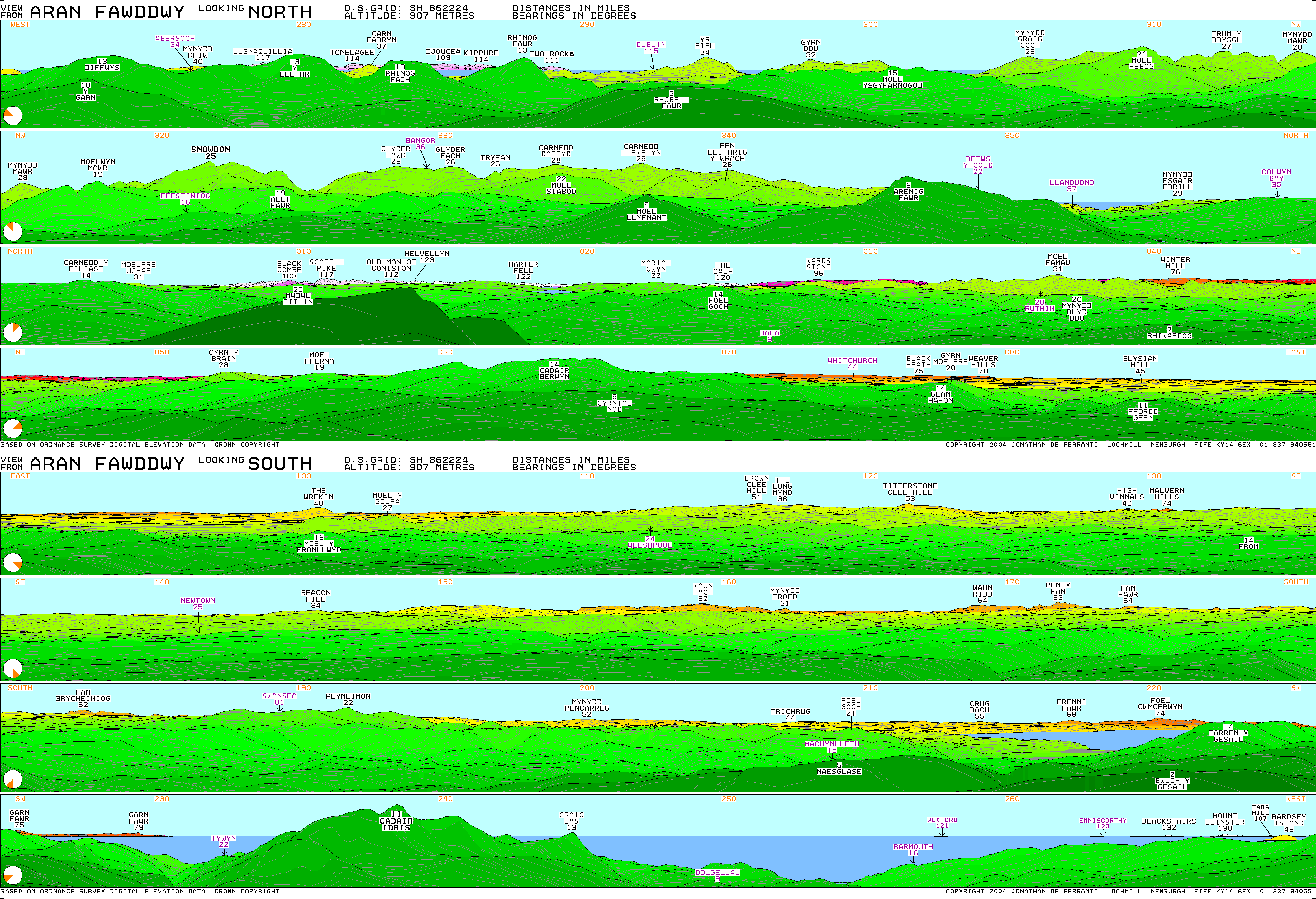
Aran Fawddwy is a mountain in southern Snowdonia, Wales, United Kingdom. It is the highest point (county top) of the historic county of Merionethshire (for local government purposes, it lies within the current council area of Gwynedd). It is the highest peak in the Aran mountain range, the only peak in Wales outside North Snowdonia above 900m, and higher than anywhere in the United Kingdom outside Northern Snowdonia, the Scottish Highlands (and islands) and the Lake District. The nearest small settlements to the mountain are Dinas Mawddwy to the south, Llanymawddwy to the southeast, Llanuwchllyn on the shores of Bala Lake to the north, and Rhydymain to the west. The nearest settlements with around 2,000 people are Bala and Dolgellau. On the eastern slopes of Aran Fawddwy is the small lake named Creiglyn Dyfi, the source of the River Dyfi. Its sister peak is Aran Benllyn at 885 metres (2,904 ft). [2] There is also a middle peak: Erw y Ddafad-ddu.

Contents

Geography

Aran Fawddwy, which is only 9.5 metres (31 ft)[ 29 feet according to the summary box ] short of being a member of the Welsh 3000s, is the highest peak in the Aran mountain range and the 16th highest summit in Wales. The other two Marilyns in this range are Glasgwm and Esgeiriau Gwynion. [3]

It is the highest British mountain south of Snowdon, and is the principal summit of the predominant southwest–northeast ridge between Dolgellau and Bala, southern Snowdonia, a ridge that continues westwards as Cadair Idris.

Ascent

Aran Fawddwy is best ascended from Cywarch in the south, [4] although a longer ridge climb is possible from the Bala side. The mountain forms a long rocky ridge with Aran Fawddwy as the highest point, but Aran Benllyn is another notable summit. The eastern side is extremely steep, falling spectacularly in crags to a series of glacial cwms or corries which also enclose two small lakes (Creiglyn Dyfi and Llyn Lliwbran). The western slopes are also rocky, but less steep and more uniform. The view from the summit is extensive, covering most of the mountain ranges of North Wales and as far south as the Brecon Beacons and Pembrokeshire peninsula. On an exceptionally clear day, the Lake District in England and the Wicklow Mountains in Ireland are visible. [5]

A cairn is placed on the eastern ridge as a memorial to RAF Mountain Rescue team member Michael Robert Aspain, who was struck and killed by lightning in 1960. [6]

See also

Related Research Articles

<span class="mw-page-title-main">Snowdonia</span> Mountainous region and national park in north Wales

Snowdonia, or Eryri, is a mountainous region and national park in northwestern Wales. It contains all 15 mountains in Wales over 3000 feet high, including the country's highest, Snowdon, which is 1,085 metres (3,560 ft) tall. These peaks are all part of the Snowdon, Glyderau, and Carneddau ranges in the north of the region. The shorter Moelwynion and Moel Hebog ranges lie immediately to the south.

<span class="mw-page-title-main">Merionethshire</span> Historic county of Wales

Merionethshire or Merioneth is one of thirteen historic counties of Wales, a vice county and a former administrative county.

<span class="mw-page-title-main">Tryfan</span> Mountain in Wales

Tryfan is a mountain in the Ogwen Valley, Snowdonia, Wales. It forms part of the Glyderau group, and is one of the most recognisable peaks in Britain, having a classic pointed shape with rugged crags. At 917.5 metres above sea level, it is the fifteenth-highest mountain in Wales. Tryfan was voted Britain's favourite mountain by Trail magazine.

<span class="mw-page-title-main">Glyder Fawr</span> Mountain in Snowdonia, Wales

Glyder Fawr is a mountain in Snowdonia, Wales, the highest peak in the Glyderau range at just over 1,000 metres. It is the fifth-highest mountain in Wales and has several walking and scrambling routes leading to its summit. According to Sir Ifor Williams, the word "Glyder" derives from the Welsh word "Gludair", meaning a heap of stones.

<span class="mw-page-title-main">Carnedd Llewelyn</span> Mountain in Wales

Carnedd Llewelyn, also spelled Carnedd Llywelyn, is a mountain massif in the Carneddau range in Snowdonia, north-west Wales. It is the highest point of the Carneddau and the second highest peak by relative height in Wales, 49th in the British Isles and lies on the border between Gwynedd and Conwy.

Craig Cywarch is an extensive crag looming above Cwm Cywarch. The nearest village is Dinas Mawddwy on the A470.

<span class="mw-page-title-main">River Dyfi</span> River in Mid Wales

The River Dyfi, also known as the River Dovey; DUH-vee), is an approximately 30-mile (48-kilometre) long river in Wales.

<span class="mw-page-title-main">Dinas Mawddwy</span> Village in Wales

Dinas Mawddwy is a village in the community of Mawddwy in south-east Gwynedd, north Wales. It lies within the Snowdonia National Park, but just to the east of the main A470, and consequently many visitors pass the village by. Its population is roughly 600. The village marks the junction of the unclassified road to Llanuwchllyn which climbs up through the mountains to cross Bwlch y Groes at its highest point, the second highest road pass in Wales. This minor road also provides the closest access to the mountain Aran Fawddwy and is the nearest settlement to Craig Cywarch.

<span class="mw-page-title-main">Maesglase</span> 678m high mountain in Wales

Maesglase is a mountain in Snowdonia, North Wales, situated approximately four miles to the south-west of Aran Fawddwy. It is the highest of the Dyfi Hills.

<span class="mw-page-title-main">Gwaun Lydan</span>

Gwaun Lydan is the top of Aran Fawddwy in the south of the Snowdonia National Park in Gwynedd, Wales. It is located at the end of the south ridge. The summit comprises a small boggy plateau, the highest point being a peat hag marked by a few stones.

<span class="mw-page-title-main">Gwaun y Llwyni</span>

Gwaun y Llwyni is a subsidiary summit of Aran Fawddwy in southern Snowdonia, Wales. It forms a part of the Aran mountain range.

<span class="mw-page-title-main">Foel Hafod-fynydd</span>

Foel Hafod-fynydd is a subsidiary summit of Aran Fawddwy in southern Snowdonia, North Wales, Wales, United Kingdom. It tops the east ridge of Erw y Ddafad-ddu. Creiglyn Dyfi nestles in the bowl between Foel Hafod-fynydd and Aran Fawddwy.

<span class="mw-page-title-main">Erw y Ddafad-ddu</span>

Erw y Ddafad-ddu is a subsidiary summit of Aran Fawddwy in southern Snowdonia, North Wales, Wales, United Kingdom. It is the third highest peak in the Aran mountain range.

<span class="mw-page-title-main">Aran Benllyn</span>

Aran Benllyn is a subsidiary summit of Aran Fawddwy in southern Snowdonia, North Wales, Wales, United Kingdom. It is the second highest peak in the Aran mountain range.

<span class="mw-page-title-main">Glasgwm</span>

Glasgwm is a mountain in Gwynedd, Wales forming part of the Aran range in southern Snowdonia. It is one of the three Marilyns that make up the range, the others being Aran Fawddwy and Esgeiriau Gwynion. To the west is Maesglase and the Dyfi hills, while to the south-west lies Cadair Idris. To the south lies the Plynlimon range. It is 779 metres (2,556 ft) high.

<span class="mw-page-title-main">Carnedd y Filiast (Cerrigydrudion)</span> Mountain in Gwynedd, Wales

Carnedd y Filiast is a mountain near Cerrigydrudion on the border of the Snowdonia National Park, North Wales and is 669 metres (2,195 ft) high.

<span class="mw-page-title-main">Foel y Geifr</span>

Foel y Geifr is a subsidiary summit of Esgeiriau Gwynion, and included in a group of hills known as the Hirnantau. These hills rise from the south east shores of Bala Lake. Confusion arises when trying to establish to which mountain range these belong to. Since, Foel y Geifr forms part of the Hirnant horseshoe, many consider it to be a Berwyn peak. However, geographically it belongs to the Aran Fawddwy group, its parent peak being Esgeiriau Gwynion. It is the eastern outpost of the Arans.

<span class="mw-page-title-main">Cribin Fawr</span>

Cribin Fawr is a mountain in Snowdonia, North Wales, situated approximately four miles to the south-west of Aran Fawddwy. It is one of the peaks in the Dyfi hills, a subgroup of the Cadair Idris group. It is a top of Maesglase, connected to its parent peak by the Craig Portas ridge. The top of Cribin Fawr is a large open plateau of peat bog. To the west is Waun-oer, to the north Cadair Idris, to the south Maesglase and Glasgwm to the east.

<span class="mw-page-title-main">Pen yr Allt Uchaf</span>

Pen yr Allt Uchaf is a subsidiary summit of Aran Fawddwy in the south of the Snowdonia National Park in Gwynedd, Wales. The summit is the highest point on a ridge branching off to the west of Aran Fawddwy's south ridge.

<span class="mw-page-title-main">Pen y Brynfforchog</span> Mountain in Gwynedd, Wales

Pen y Brynfforchog is subsidiary summit of Glasgwm in North Wales forming part of the Aran range in southern Snowdonia.

References

  1. Crocker, Chris; Graham Jackson. "Mountaineering & Rock Climbing in the UK: Aran Fawddwy". Database of British Hills. Mountain Days.net. Archived from the original on 19 July 2011. Retrieved 8 April 2008.
  2. Crocker, Chris; Graham Jackson. "Mountaineering & Rock Climbing in the UK: Aran Benllyn". Database of British Hills. Mountain Days.net. Archived from the original on 19 July 2011. Retrieved 8 April 2008.
  3. Nuttall, John & Anne (1999). The Mountains of England & Wales - Volume 1: Wales (2nd edition ed.). Milnthorpe, Cumbria: Cicerone. ISBN   1-85284-304-7.
  4. Walk 1190 – Aran Fawddwy from Cwm Cywarch – Snowdonia Gwynedd – a walk description from Walking Britain
  5. http://viewfinderpanoramas.org/panoramas/WAL/FAWDDWY.gif, View from Aran Fawddwy summit
  6. Image from www.geograph.org.uk