Related Research Articles

The Dearne Valley is an area of South Yorkshire, England, along the River Dearne. It encompasses the towns of Wombwell, Wath-upon-Dearne, Swinton, Conisbrough and Mexborough, the large villages of Ardsley, Bolton on Dearne, Goldthorpe, Thurnscoe, Darfield, Stairfoot and Brampton Bierlow, and many other smaller villages and hamlets.

Blaby is a large village in the Blaby District in central Leicestershire, England, some five miles south of Leicester city centre. At the time of the 2011 census, Blaby had a population of 6,194, a slight fall from 6,240 in 2001 figures). Blaby's proximity to the city causes it to form part of the Leicester Urban Area.
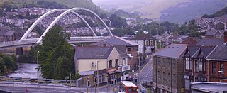
Porth is a town and a community in the county borough of Rhondda Cynon Taf, within the historic county boundaries of Glamorgan, Wales. Lying in the Rhondda Valley, it is regarded as the gateway connecting the Rhondda Fawr and Rhondda Fach valleys due to both valleys meeting at Porth. The Welsh word "porth" means "gate". Porth is a predominantly English-speaking community.

Thurnscoe is a village in the metropolitan borough of Barnsley in South Yorkshire, England. The village falls within the Dearne North ward of the Barnsley MBC. Historically within the West Riding of Yorkshire, the village is approximately 9 miles (14 km) from Barnsley and 8 miles (13 km) from Doncaster. It is served by Thurnscoe railway station with bus links provided by Stagecoach.
Wednesfield is a town and historic village in the City of Wolverhampton, West Midlands, England, It is 2 miles (3.2 km) east-northeast of Wolverhampton city centre and about 10 miles (16 km) from Birmingham and is part of the West Midlands conurbation. It was historically within the county of Staffordshire.

The Afon Mawddach is a river in Gwynedd, Wales, which has its source in a wide area SH820300 north of Dduallt in Snowdonia. It is 28 miles (45 km) in length, and is much branched; many of the significant tributaries are of a similar size to the main river. The catchment area is bounded to the east by the Aran Fawddwy massif and to the west and north by the Harlech dome which forms a watershed just south of Llyn Trawsfynydd.

Abergwyngregyn is a village and community of historical note in Gwynedd, a county and principal area in Wales. Under its historic name of Aber Garth Celyn it was the seat of Llywelyn ap Gruffudd. It lies in the historic county of Caernarfonshire.
Aberarth is a village in Ceredigion, Wales, in the community of Dyffryn Arth, on the southern end of Cardigan Bay between Aberystwyth and Cardigan at the mouth of the River Arth on the A487 road. The Wales Coast Path passes through the village.

Unorganized North Algoma District is an unorganized area in northeastern Ontario, Canada, comprising all areas in Algoma District, north of the Sault Ste. Marie to Elliot Lake corridor, which are not part of an incorporated municipality or a First Nation. It covers 44,077.03 km2 (17,018.24 sq mi) of land, and had a population of 6050 in 2021. Many of these communities were/are stations on the Algoma Central Railway or were logging/mining towns.

Abergwesyn is a village in the Welsh county of Powys, in mid-Wales, at the start of the Abergwesyn valley and at the confluence of the Afon Irfon and the Afon Gwesyn. It is 52 miles (84 km)from Cardiff and 158 miles (254 km) from London.

Crynant is a village and community in the Dulais Valley in Wales. It lies 7¾ miles north-east from the town of Neath in Neath Port Talbot, situated between the mountains of Mynydd Marchywel to the west, Hirfynydd to the east and Mynydd y Drum to the north.
Keresley is a suburban village and civil parish in the City of Coventry, West Midlands, England, about 4.5 miles (7 km) north of Coventry city centre and 3.5 miles (6 km) southwest of Bedworth. According to the 2001 census, the parish had a population of 791 falling to 713 at the 2011 Census, although the 2018 population was estimated at 783.

Netherton is an area of the Metropolitan Borough of Dudley, 1.5 miles (2 km) south of Dudley town centre in the West Midlands of England, but historically in Worcestershire. Part of the Black Country, Netherton is bounded by nature reserves to the east and west, and an industrial area and the Dudley Southern By-Pass to the north.

The River Dyfi, also known as the River Dovey, is an approximately 30-mile (48-kilometre) long river in Wales.

Tahawus was a village in the Town of Newcomb, Essex County, New York, United States. It is now a ghost town situated in the Adirondack Park. Tahawus is located in Essex County within the unpopulated northern area designated to the town of Newcomb. Tahawus was the site of major mining and iron smelting operations in the 19th century. Although standing as recently as 2005, the last mining facilities have since been demolished and removed.

Orston is an English village and civil parish in the Rushcliffe borough of Nottinghamshire, 15 miles east of Nottingham. It borders the parishes of Scarrington, Thoroton, Flawborough, Bottesford and Elton on the Hill. The population at the 2011 census was 454.
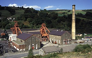
Rhondda Heritage Park, Trehafod, Rhondda, South Wales, is a tourist attraction which offers an insight into the life of the coal mining community that existed in the area until the 1980s.

Brogyntyn, or Porkington, is a mansion in the parish of Selatyn to the north-west of Oswestry in Shropshire, England. Brogyntyn Hall was the home of the Ormsby-Gore family from 1815, and had previously been the estate of their ancestors the Maurices and Owens since the sixteenth century. It was abandoned and uninhabited from around 1985.
Esclusham is a community and electoral ward in Wrexham County Borough, Wales.
Marley Hill is a former colliery village about six miles to the south west of Gateshead, near the border between Tyne and Wear and County Durham. It has been part of the Metropolitan Borough of Gateshead since 1974. Prior to this it was part of Whickham Urban District. It lies within the Whickham South & Sunniside electoral ward of the Blaydon parliamentary constituency.
References
- 1 2 "Glasgwm/Craig Cywarch". summitpost.org. 2006–2010. Retrieved 1 November 2010.

52°43′40″N3°40′38″W / 52.7278°N 3.6773°W
| | This Wales-related article is a stub. You can help Wikipedia by expanding it. |