
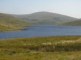
Aran Fawddwy is a mountain in southern Snowdonia, Wales, United Kingdom. It is the only peak in Wales outside North Snowdonia above 900m, and higher than anywhere in Great Britain outside Northern Snowdonia, the Scottish Highlands and the Lake District. The nearest urban centres to the mountain are Dinas Mawddwy to the south, Llanymawddwy to the southeast, Llanuwchllyn on the shores of Bala Lake to the north, and Rhydymain to the west. The nearest settlements with around 2,000 people are Bala and Dolgellau. On the eastern slopes of Aran Fawddwy is the small lake named Creiglyn Dyfi, the source of the River Dyfi. Its sister peak is Aran Benllyn at 885 metres (2,904 ft). There is also a middle peak- Erw y Ddafad-ddu.

Arenig Fawr is a mountain in Snowdonia, North Wales, close to Llyn Celyn reservoir, alongside the A4212 between Trawsfynydd and Bala.
Pen Pumlumon Llygad-bychan is a subsidiary summit of Pen Pumlumon Fawr and the third highest summit on the Plynlimon massif, a part of the Cambrian Mountains in the county of Ceredigion, Wales. It is not named on Ordnance Survey walking maps.
Y Garn is a subsidiary summit of Pen Pumlumon Fawr and the fourth highest peak on the Plynlimon massif, a part of the Cambrian Mountains in the county of Ceredigion, Wales.
Pen Pumlumon Arwystli is the second highest summit on the Plynlimon massif, a part of the Cambrian Mountains in the county of Ceredigion, Wales.

Gwaun y Llwyni is a subsidiary summit of Aran Fawddwy in southern Snowdonia, Wales. It forms a part of the Aran mountain range.

Erw y Ddafad-ddu is a subsidiary summit of Aran Fawddwy in southern Snowdonia, North Wales, Wales, United Kingdom. It is the third highest peak in the Aran mountain range.

Aran Benllyn is a subsidiary summit of Aran Fawddwy in southern Snowdonia, North Wales, Wales, United Kingdom. It is the second highest peak in the Aran mountain range.

Waun Camddwr is a top of Aran Fawddwy in the south of the Snowdonia National Park in Gwynedd, Wales. It is the highest point on a wide boggy area between the summits of Aran Fawddwy and Glasgwm. It was surveyed after the first Nuttall list was compiled, and found to have just enough prominence to be included. The summit is a rocky outcrop amid an area of heather, long grass and peat bog. Gwaun y Llwyni rises to the south of the summit.

Binn idir an dá Log at 702 metres (2,303 ft), is the 87th–highest peak in Ireland on the Arderin scale, and the 108th–highest peak on the Vandeleur-Lynam scale. Binn idir an dá Log is situated at the centre of the long north-west to south-east cental spine of the Maumturks mountain range in the Connemara National Park in Galway, Ireland. Binn idir an dá Log is the tallest mountain in the range.

Mynydd Perfedd is a mountain in Snowdonia, Wales, forming part of the Glyderau. The summit has a shelter cairn, offering good views of Foel-goch's north-eastern face, and the Carneddau.

Carnedd y Filiast is a mountain near Cerrigydrudion on the border of the Snowdonia National Park, North Wales and is 669 metres (2,195 ft) high.

Foel y Geifr is a subsidiary summit of Esgeiriau Gwynion, and included in a group of hills known as the Hirnantau. These hills rise from the south east shores of Llyn Tegid. Confusion arises when trying to establish to which mountain range these belong to. Since, Foel y Geifr forms part of the Hirnant horseshoe, many consider it to be a Berwyn peak. However, geographically it belong to the Aran Fawddwy group, its parent peak being Esgeiriau Gwynion. It is the eastern outpost of the Arans.
Cribin Fawr is a mountain in Snowdonia, North Wales, situated approximately four miles to the south-west of Aran Fawddwy. It is one of the peaks in the Dyfi hills, a subgroup of the Cadair Idris group. It is a top of Maesglase, connected to its parent peak by the Craig Portas ridge. The top of Cribin Fawr is a large open plateau of peat bog. To the west is Waun-oer, to the north Cadair Idris, to the south Maesglase and Glasgwm to the east.

Pen yr Allt Uchaf is a subsidiary summit of Aran Fawddwy in the south of the Snowdonia National Park in Gwynedd, Wales. The summit is the highest point on a ridge branching off to the west of Aran Fawddwy's south ridge.

Pen y Brynfforchog is subsidiary summit of Glasgwm in North Wales forming part of the Aran range in southern Snowdonia.

Letterbreckaun at 677 metres (2,221 ft), is the 129th–highest peak in Ireland on the Arderin scale, and the 159th–highest peak on the Vandeleur-Lynam scale. Letterbreckaun is situated is situated in the middle sector of the long north-west to south-east cental spine of the Maumturks mountain range in the Connemara National Park in Galway, Ireland. Letterbreckaun is the 2nd-tallest mountain in the range.

Binn Mhór at 661 metres (2,169 ft), is the 140th–highest peak in Ireland on the Arderin scale, and the 171st–highest peak on the Vandeleur-Lynam scale. Binn Mhór is situated on the southern side of the pass of Máméan, on a small massif that includes Mullach Glas, and Corcogemore ; this massif is at the far southeastern sector of the long north-west to south-east cental spine of the Maumturks mountain range in the Connemara National Park in Galway, Ireland. Binn Mhór is the 3rd-highest mountain in the Maumturks range.

Binn Chaonaigh at 633 metres (2,077 ft), is the 185th–highest peak in Ireland on the Arderin scale, and the 223rd–highest peak on the Vandeleur-Lynam scale. Binn Chaonaigh is situated in the middle sector of the long north-west to south-east cental spine of the Maumturks mountain range in the Connemara National Park in Galway, Ireland. Binn Chaonaigh is the 4th highest mountain in the Maumturks range.

Leenaun Hill at 618 metres (2,028 ft), is the 201st–highest peak in Ireland on the Arderin scale, and the 243rd–highest peak on the Vandeleur-Lynam scale. Leenaun Hill lies on a massif that overlooks Leenaun village and Killary Harbour, and which is at the far northeastern sector of the Maumturks mountain range in the Connemara National Park in Galway, Ireland; this massif is connected to the main range via the "Col of Despondency". Leenaun Hill is the 6th-highest mountain in the Maumturks, and its grassy massif, constructed from sandstone and siltstone, contrasts with the rocky ridges and summits constructed from quartzites, grits, and graphitic, of the middle and southern sectors of the range.
