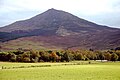
Mount Brandon or Brandon (Irish: Cnoc Bréanainn, meaning 'Brendan's hill'),[4] at 952 metres (3,123ft), is one of the ten highest peaks in Ireland, being the 8th–highest peak in Ireland on the Arderin list, and the 9th–highest on the Vandeleur-Lynam list.[5] Brandon is the highest Irish mountain outside the MacGillycuddy's Reeks range and has the greatest prominence of any Irish peak except Carrauntoohil, Ireland's highest mountain.[5]
Mount Brandon is at the centre of a long high ridge called the Brandon Group range of mountains in the Dingle Peninsula in County Kerry. The ridge contains seven other major peaks (i.e. above 2,000 ft in height); one is the similarly named Brandon Peak (840 metres).[5][6] The positioning and dimensions of the Brandon Group ridge have made it the scene of several air accidents over the years.[7] The mountain, and range, is named after Saint Brendan, and is the end of a Christian pilgrimage trail known as Cosán na Naomh. It is also well regarded for hill walking with routes such as the 4–5-hour Faha Route (also called The Pilgrim's Path), and the 6–7-hour traverse of the entire range known as "one of the finest ridgewalks in Ireland".[6][5][8]
Brandon is composed of sandstone particles of various sizes collectively known as Old Red Sandstone.[7] Old Red Sandstone has a purple–reddish colour, and has virtually no fossils.[7][9] The colour gave its name to nearby Purple Mountain.[7] The composition of Old Red Sandstone is variable and contains quartz stones, mudstones, siltstones, and sandstone particles (conglomerate rock boulders with quartz pebbles are visible).[7] They are described by the Geological Survey of Ireland as the oldest Devonian rocks in Ireland.[10]
Mount Brandon itself is in the middle of a long and high ridge known as the Brandon Group,[4] which runs north–south for 10 kilometres (6.2mi) across the width of the Dingle peninsula. As well as Mount Brandon, the Brandon Group ridge has seven other major classified peaks (see list below), including the similarly named Brandon Peak840 metres (2,760ft), Benagh822 metres (2,697ft), Faha Ridge809 metres (2,654ft), Gearhane803 metres (2,635ft), Masatiompan762 metres (2,500ft), Piaras Mór746 metres (2,448ft), and An Scraig623 metres (2,044ft).
The most distinctive aspect of the Brandon Group is the contrast between the gentle grassy slopes on its western side, and the sharp cliffs and deep corries of its eastern side; an effect that the Brandon Group's long north–south ridge exactly separates.[6] Mount Brandon owes its craggy shape to the work of glaciers during the ice age, which gouged out a series of corries on the eastern flank of the mountain. The summit of Mount Brandon is rounded and smooth as it was likely a nunatuk (like Lugnaquilla in Wicklow), and presents a stark contrast to Brandon Peak, or Barr an Ghéaráin, which is alpine in appearance.[6]
The chain of paternoster lakes from Brandon's east corrie; Faha Ridge is middle left, and Benagh back left
On Brandon's deep eastern corrie, flanked by Faha Ridge to its north, is a series of rocky plateaus, each of which has a small paternoster lake; over ten lakes grow in size descending the mountain.[11] From highest they are, the Locha Chom an Chnoic (Coumaknock Loughs), Loch na Lice (Lough Nalacken) and Loch Cruite (Lough Cruttia).[6][11] This corrie's natural environment, and positioning on the Faha Route, means it is regularly photographed.[6]
The mountain is called Brandon Mountain, Mount Brandon and Brandon on various maps.[4]
Brandon takes its name from Saint Brendan the Navigator, or Bréanainn, who is said to have been born in what is now County Kerry in 484 AD, and is chiefly known for his legendary voyage in a boat of wood and leather to discover the "Isle of the Blessed", also called Saint Brendan's Island.[16] In the story of Brendan's life (titled, the Beatha Bhréanainn, or the Latin version, the Vita Brendani), he spent three days fasting on the mountain before his voyage, was visited by an angel, and experienced a vision of "a great land to the west";[17][18] the mountain is described as being surrounded by the ocean, which fits with the topography of Mount Brandon.[4]
Irish academic Paul Tempan wrote in his 2010 Irish Hill and Mountain Names, that it is likely that the mountain was a source of pilgrimage even before both St. Brendan and the arrival of Christianity altogether.[4] Its importance may be due to the fact that, being so far west and so high, it is the place where the sun can be seen the latest as it sinks below the horizon.[4] Tempan notes that the medieval story about Brendan's life calls the mountain Sliabh nDaidche in the Irish version, or Mons Aitche in the Latin version; and that the Irish academic Dr Alan Mac an Bhaird, had translated this as "mountain of Faithche", as Brandon stands in the Faha townland.[4] However, some believe that the Mons Aitche name refers to Slieve Aughty, rather than to Mount Brandon.[19]
Some sources link the name with the voyages of Bran mac Febail, however, this is considered less likely.[20]
Hill walking
The summit of Brandon seen from The Saint's Route in the west.
The quickest and easiest route to the summit of Mount Brandon is from the west via the final stages of the medieval pilgrim path, The Saint's Route (Irish: Cosán na Naomh), which begins 18 kilometres (11mi) away in Ventry.[21] The route starts from the car park of Ballybrack (Irish: Baile Breac) (W434094), and follows the straight grassy path, marked by large crosses, to the summit of Mount Brandon; then retracing back to Ballybrack. The 8-kilometre (5.0mi) route takes 3–4 hours.[22][23] A longer 5-hour variation is to continue north along the summit ridge from Mount Brandon to Piaras Mor, and then descend to Ballyknockane.[24]
East face of Mount Brandon seen from the Faha Route, at Cloghane.
A scenic variation is the 9-kilometre (5.6mi) 4–5-hour Faha Route, the Pilgrim's Path,[a] which starts from the east via the car park at the Faha Grotto (Q493119) just outside Cloghane. The route to the summit is marked, and offers views of the deep corries and paternoster lakes on Brandon's glaciated east face. It follows a trail below the Faha Ridge to the summit; then retracing back to Faha Grotto.[25][26]
Benagh (left), and Faha Ridge (middle), from Brandon North Top
The full ridge walk of the entire Mount Brandon range, regarded as "one of the finest ridge walks in Ireland", crosses the full 15-kilometre (9.3mi) ridge of the Brandon Group from the Conor Pass to Masatiompan and takes 6–7 hours.[6] The route from the Conor Pass to Mount Brandon and back to the Conor Pass is even longer, at 21 kilometres (13mi) and takes up to 8 hours to complete.[6]
Due to its link with Saint Brendan, the mountain is popular with Irish Catholicpilgrims.[4] The mountain's relative height and status of being at an extreme westerly point appears to have been of great importance to Saint Brendan.[17][4] A pilgrimage route called Cosán na Naomh ("The Saints Road") begins at Cill Mhic an Domhnaigh (Kilvickadowning) on Ventry Strand at the southern end of the Dingle peninsula, and ends at Séipéilín Bréanainn ("Brendan's Oratory") on Brandon's summit.[21][22]Sáipéilín Bréanainn is the remains of a stone building believed to have been used by Saint Brendan. The path to the peak is marked by small white crosses and the peak itself is topped by a large metal cross. It is speculated the pilgrimage originated in pre-Christian times as a Lughnasadh ritual.[41][17]
In 1997, the Irish Heritage Council set up the Pilgrim Paths Project to restore walking routes along Irish medieval pilgrimage paths.[42] One of the routes chosen was Cosán na Naomh, and an 18–kilometre way-marked trail was constructed between Ventry Strand and the grotto at Ballybrack at the foot of Mount Brandon.[20][43] The trail has been developed to the standard required by the Irish Sports Council for National Waymarked Trails in Ireland.[44] For safety reasons, it was decided not to mark the trail to the end of the medieval route at the summit of Brandon, but to finish at Ballybrack.[45] The starting point at Ventry is one of the places pilgrims would have come ashore.[46] The trail passes a number of important ecclesiastical heritage sites including Gallarus Oratory and Kilmalkedar monastic site.[47]
Aircraft accidents
Wreckage of Sunderland Aircraft, Faha Ridge 1943.
Between 1940 and 1943 a number of Allied and Axis aircraft crashed on Brandon and the Faha Ridge.[7]
20 August 1940: A LuftwaffeFocke-Wulf Fw 200 Condor crash-landed on Faha Ridge, the crew of six survived and were the first known aircrew from Germany to land in Ireland during the Second World War. A plaque commemorating this event is on display in O'Connor's Bar and Guest House in Cloghane Village.[48]
28 July 1943: A BOAC Civilian Short Sunderland III Flying Boat crashed due to a navigation error onto the lower slopes of Mount Brandon while flying from West Africa to Foynes Flying Boat Base. Ten of the twenty-five on board were killed in the wreck. An anchor from the wreck is in O'Connor's Bar and Guest House.[49][50]
22 August 1943: A RAFShort Sunderland IIIFlying Boat belonging to 201 Squadron crashed while flying a patrol in the Atlantic, out of Castle Archdale. It crashed into the lower slopes of Mount Brandon. Eight of the crew of eleven were killed. A plaque commemorating those killed is in O'Connor's Bar and Guest House.[51]
20 December 1943: A RAFVickers Wellington belonging to 304 Squadron based out of Predannack Airfield crashed directly into Mount Brandon. All of the six Polish crew members were killed. Engines from the wreck are also on display in O'Connor's Bar.[52]
↑This is sometimes confused with the Cosán na Naomh on the west side, which can also be called the Pilgrim's Path, hence the use of Faha Route to properly distinguish it
↑From the vicinity of Cloghane church there is a strange optical illusion whereby this peak seems higher than the summit, though it is actually over 100m lower.[4]
↑"An Fhaiche / Faha is the name of the townland in which this peak is situated. The grotto at which the traditional ascent of the mountain begins is further down in the same townland. The walls E of the summit were identified as the remains of an inland promontory fort by archaeologist Barry Raftery. For information on this fort, see Archaeology Ireland Heritage Guide No. 29 (published March 2005)".[4]
↑Máire MacNeill comments on the place-names around Brandon as follows: From An Seabhac's compendium of the place-names of the district we learn that several places on the mountain have names suggestive of myths which recur at other Lughnasa sites, e.g. Macha an Mhíl (the Beast's Pasture), Faill na nDeamhan (the Demons' Cliff), Com na Caillighe (the Hag's Recess), Loch na Mná (the Woman's Lake), Cnoc an Tairbh (the Bull's Hill), etc.[4]
↑Tiompán can also mean a deep sheltered cove. Nearby there is such a cove at Sauce Creek.[4]
↑This name is interpreted as 'big Pierce' in the Ordnance Survey Name Book. However, An Seabhac reports that in his time, nearly a century later, nobody in the locality had an explanation for the name but they did not think it was related to the personal name Piaras. There is a lower peak to the N called Piaras Beag. On the saddle between Piaras Mór and Masatiompan is an ogham stone bearing an inscription which translates as: Ronan, the priest son son of Camogann. There is a chi-ro monogram (representing 'Christ') above it and a Greek cross in a circle on the other side (Barrington, Discovering Kerry, 180).[4]
↑Also known as Cnoc Bhaile Uí Shé [OSI], 'hill of Baile Uí Shé', from Ballyhea(-bought) townland. The English form Ballysitteragh could be from Baile Suiteoireach, 'the townland of the camp/barracks', but the circumstances of its naming are unclear. Coumhenry, Coumgraig and Coumthrive are hollows below the mountain on the N. side.[4]
12Paul Tempan notes that the Irish name Macha na gCab and the anglicised name Beennabrack have very different meanings. It seems unlikely that they originally referred to the same feature. An Seabhac gives the name Binn na mBroc ('peak of the badgers') for this hill (TCCD, 143, 233), which shows that Beennabrack is a corruption. He does not mention Macha na gCab.[4]
↑Sauce Creek is derived from Irish sás, 'noose', a name referring to the fact that waves and currents make it very difficult to leave this cove by boat.[4]
↑"Hill Lists: Furths". Scottish Mountaineering Club. Archived from the original on 5 October 2018. Retrieved 29 October 2018. The list of peaks of 3000ft or more within the United Kingdom and the Republic of Ireland outside (furth) of Scotland. There are currently 34 Furths.
12Chett Raymo (9 October 2004). "Mystic mountain". The Guardian. Retrieved 24 March 2020. Mount Brandon, a great solitary peak on Ireland's west coast, has been a holy site for centuries. Chet Raymo takes the pilgrim's path to the top
↑Ger O'Regan (2005). "Crash into Faha Ridge". Wartime Aircraft Crashes in County Kerry. Luftwaffe Focke Wulf 200 Condor of KG40 departed Bordeaux in Western France on the morning of 20 August 1940, to carry out weather reconnaissance and pressure readings off the north-west coast of Ireland. As the huge 4 engine aircraft with a crew of 6 straddled the coastline of Mayo, Galway and Clare it developed engine problems and the pilot decided to try and return home. The problems intensified and therefore a decision was made to force land the aircraft at sea rather than attempt to land in the dense fog not knowing exactly where they were. Through the mist one of the crew could just make out Tralee Bay and in particular Hogs Head. The pilot, Captain Kurt Mollenhauer, from Cuxhaven, set course due west as the aircraft began to descend in dense fog; they were heading for Mount Brandon.
↑Ger O'Regan (2005). "Crash into Mount Brandon". Wartime Aircraft Crashes in County Kerry. Capt. Allitt would have had only seconds to react when he would have seen grass below his aircraft at an altitude of approximately 2,000ft. before it impacted into large boulders just below the summit of Mount Brandon. Of the 28 on board, 10 died instantly including Allitt, Noth and Díarmuid Hartigan who was only 70 miles from his home. The crash site was a scene of utter devastation where fire engulfed almost all of the aircraft except the tail section, which bore the registration G–AGES. Amongst the cargo recovered were post from British personnel in Japanese administered POW camps in Java. For several months mail continued to be found several miles from the crash site and locals would themselves post the letters to the addressees.
↑Ger O'Regan (2005). "2nd Crash into Mount Brandon". Wartime Aircraft Crashes in County Kerry. The village of Cloghane had only just about recovered from the B.O.A.C. loss of another Sunderland on 28 July 1943, when tragedy called again 25 days later. Another aircraft came to grief in exactly the same spot and once again with a major loss of life on 22 August 1943. A Royal Air Force Sunderland Flying Boat, DD848, of 201 Squadron, Coastal Command, out of Castle Archdale on Lower Loch Erne, County Fermanagh with a crew of eleven, was intent on hunting U–Boats in The Bay of Biscay but found the inner slopes of Mt. Brandon instead. Again, as on 25 days earlier this area was a scene of carnage with only three survivors.
Dillion, Paddy (1993). The Mountains of Ireland: A Guide to Walking the Summits. Cicerone. ISBN978-1852841102.
Fairbairn, Helen (2016). Ireland's Wild Atlantic Way: A Walking Guide (Collins Press Guide). Collins Press. ISBN978-1848892675.
Fairbairn, Helen (2014). Ireland's Best Walks: A Walking Guide. Collins Press. ISBN978-1848892118.
MountainViews (Simon Stewart) (2013). A Guide to Ireland's Mountain Summits: The Vandeleur-Lynams & the Arderins. Collins Books. ISBN978-1-84889-164-7.
Ryan, Jim (2006). Carrauntoohil and MacGillycuddy's Reeks: A Walking Guide to Ireland's Highest Mountains. Collins Press. ISBN978-1905172337.
Religious
Harbison, Peter; Lynam, Joss (2002). Cosán na Naomh: The Saint's Road, Dingle Peninsula, County Kerry. Medieval Irish Pilgtim Paths. Vol.1. Kilkenny: Heritage Council. ISBN1-901137-30-9.
This page is based on this Wikipedia article Text is available under the CC BY-SA 4.0 license; additional terms may apply. Images, videos and audio are available under their respective licenses.