Related Research Articles
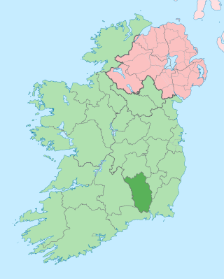
County Kilkenny is a county in Ireland. It is in the province of Leinster and is part of the Southern Region. It is named after the city of Kilkenny. Kilkenny County Council is the local authority for the county. At the 2022 census the population of the county was 103,685. The county was based on the historic Gaelic kingdom of Ossory (Osraighe), which was coterminous with the Diocese of Ossory.

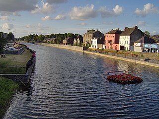
Thomastown, historically known as Grennan, is a town in County Kilkenny in the province of Leinster in the south-east of Ireland. It is a market town along a stretch of the River Nore which is known for its salmon and trout, with a number of historical landmarks in the vicinity. Visitor attractions include Jerpoint Abbey, Kilfane Glen gardens, and Mount Juliet Golf Course. The town is in a civil parish of the same name.
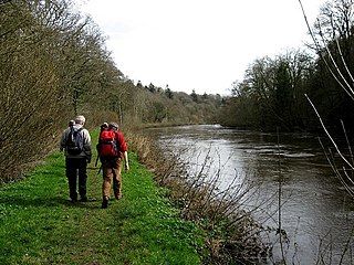
The River Nore is one of the principal rivers in the South-East Region of Ireland. The 140-kilometre-long (87 mi) river drains approximately 2,530 square kilometres (977 sq mi) of Leinster and Munster, that encompasses parts of three counties. Along with the River Suir and River Barrow, it is one of the constituent rivers of the group known as the Three Sisters.

The Western Way is a long-distance trail in Ireland. It is 179 kilometres long and begins in Oughterard, County Galway and ends in Ballycastle, County Mayo. It is typically completed in seven days. It is designated as a National Waymarked Trail by the National Trails Office of the Irish Sports Council and is managed by Coillte, Galway County Council, Mayo County Council, South Mayo Development Company and Mayo North & East Development Company.

The Kerry Way is a long-distance trail in County Kerry, Ireland. It is a 214-kilometre (133-mile) long circular trail that begins and ends in Killarney and is typically broken into nine stages. It is designated as a National Waymarked Trail by the National Trails Office of the Irish Sports Council and is managed by Kerry County Council, South Kerry Development Partnership and the Kerry Way Committee. The Way circles the Iveragh Peninsula and forms a walkers' version of the Ring of Kerry road tour. It is the longest of Ireland's National Waymarked Trails.

Inistioge is a small village in County Kilkenny, Ireland. Historically, its name has been spelt as Ennistioge, Ennisteage, and in other ways. The village is situated on the River Nore, 25 kilometres (16 mi) southeast of Kilkenny. Inistioge is in a townland and civil parish of the same name.

Bennettsbridge is a village in County Kilkenny in Ireland. It is situated on the River Nore 6 kilometres (3.7 mi) south of Kilkenny city, in the centre of the county. Bennettsbridge is a census town, and had population of 745 as of the 2016 census.
James Treacy is an Irish retired hurler who played as a left corner-back for the Kilkenny senior team.

Brandon Hill is the highest mountain in County Kilkenny, Ireland, with an elevation of 515 m (1,690 ft) and prominence at 448 m (1,470 ft). The South Leinster Way, a long-distance trail, meandering through the Barrow Valley and traverses Brandon Hill. The village of Graiguenamanagh and River Barrow are at the base of the hill. It is classified as a county high point, an Arderin, a Myrddyn Dewey, and a Marilyn.
The R700 road is a regional road in Ireland which runs northwest–southeast from Kilkenny city centre to New Ross in County Wexford.
The Barrow Way is a long-distance trail in Ireland. It is 100 kilometres long and begins in Robertstown, County Kildare and ends in St Mullin's, County Carlow, following the course of the River Barrow and the Barrow Line of the Grand Canal through counties Kildare, Carlow, Kilkenny and Laois. It is typically completed in four days. It is designated as a National Waymarked Trail by the National Trails Office of the Irish Sports Council and is managed by Waterways Ireland.

The South Leinster Way is a long-distance trail in Ireland. It is 104 kilometres long and begins in Kildavin, County Carlow and runs through County Kilkenny before ending in Carrick-on-Suir, County Tipperary. It is typically completed in five days. It is designated as a National Waymarked Trail by the National Trails Office of the Irish Sports Council and is jointly managed by Carlow County Council, Kilkenny County Council, Tipperary County Council, Carlow Local Sports Partnership, Kilkenny Trails and Coillte. It was opened on 30 November 1985 by Donal Creed, Minister of State for Sport.

The Táin Way is a long-distance trail around the Cooley Peninsula in County Louth, Ireland. It is a 40-kilometre (25-mile) long circular route that begins and ends in Carlingford. It is typically completed in two days. It is designated as a National Waymarked Trail by the National Trails Office of the Irish Sports Council and is managed by Louth County Council, Coillte and the Walks Partnership Group.

The Sligo Way is a long-distance trail mainly in County Sligo, Ireland. It is 78 kilometres long and begins in Larrigan, near Lough Talt and ends in Dromahair, County Leitrim. It is typically completed in three days. It is designated as a National Waymarked Trail by the National Trails Office of the Irish Sports Council and is managed by Sligo County Council, Sligo Integrated Development Company and the Sligo Walks Partnership.

The Suck Valley Way is a long-distance trail in Ireland. It is a 105-kilometre (65-mile) long circular route that begins and ends in Castlerea, County Roscommon. It is typically completed in five days. It is designated as a National Waymarked Trail by the National Trails Office of the Irish Sports Council and is managed by Roscommon County Council, Roscommon Integrated Development Company and the Suck Valley Committee.

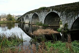
Green's Bridge, or Greensbridge, is an elegant, Palladian-style, limestone arch bridge that crosses the river Nore in Kilkenny, Ireland. The bridge is a series of five elliptical arches of high-quality carved limestone masonry with a two-arch culvert to the east. Its graceful profile, architectural design value, and civil engineering heritage endow it with national significance. Historian Maurice Craig described it as one of the five-finest bridges in Ireland. It was built by William Colles and designed by George Smith, and was completed in 1766. The bridge was 250 years old in 2016.

Gowran is a barony in the east of County Kilkenny, Ireland. The size of the barony is 430.5 square kilometres (166.2 sq mi). There are 35 civil parishes in Gowran. The chief town today is Gowran. The barony contains the ecclesiastical sites of Kilfane and Duiske Abbey The barony of Gowran is situated in the east of the county between the baronies of Fassadinin to the north, the baronies of Kilkenny, Shillelogher and Knocktopher to the west, and the barony of Ida is to the south. It borders County Carlow to the east. The M9 motorway bisects the barony.
The 1965 Kilkenny Senior Hurling Championship was the 71st staging of the Kilkenny Senior Hurling Championship since its establishment by the Kilkenny County Board. The championship ran from 4 July to 29 August 1965.
The 2021 Kilkenny Senior Hurling Championship was the 127th staging of the Kilkenny Senior Hurling Championship since its establishment by the Kilkenny County Board in 1887. The championship began on 2 October 2021 and ended on 7 November 2021.
The 1997 Kilkenny Intermediate Hurling Championship was the 33rd staging of the Kilkenny Intermediate Hurling Championship since its establishment by the Kilkenny County Board in 1929. The championship began on 15 August 1997 and ended on 19 October 1997.
References
- 1 2 3 "Nore Valley Way". IrishTrails. Irish Sports Council . Retrieved 7 August 2011.
- 1 2 3 "Next step of Nore Valley walk is completed". Kilkenny People . 11 October 2010. Archived from the original on 30 September 2011. Retrieved 7 August 2011.
- ↑ "About Us". Trail Kilkenny. Archived from the original on 18 August 2011. Retrieved 7 August 2011.
- ↑ Trail Kilkenny. "Kilkenny to Bennetsbridge, Ireland". EveryTrail. Retrieved 7 August 2011.
- ↑ Trail Kilkenny. "Thomastown to Inistioge Walk, Ireland". EveryTrail. Retrieved 7 August 2011.

