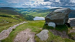
The traditional "walking man" waymarker used to designate National Waymarked Trails in Ireland
These are lists of long-distance trails in the Republic of Ireland, and include recognised and maintained walking trails, pilgrim trails, cycling greenways, boardwalk-mountain trails, and interconnected national and international trail systems.
There are 43 National Waymarked Trails by the 'National Trails Office' of the Irish Sports Council.[1] Each trail is waymarked with square black posts containing an image, in yellow, of a walking man and a directional arrow, a symbol reserved for use only by National Waymarked Trails.[2] The oldest trail in the Republic of Ireland is the Wicklow Way, which was opened in 1980, and there are now over 4,000 kilometres (2,500 miles) of waymarked trails in the Republic alone.[3] The most frequented trails are the Wicklow, Sheep's Head, Kerry, Dingle, Beara, Burren and Western Ways.[4]
The establishment of the Ulster Way in Northern Ireland in the 1970s[5] prompted the creation of the Cospóir Long Distance Walking Routes Committee (now the 'National Trails Advisory Committee' of the Irish Sports Council) to establish a national network of long-distance trails in the Republic of Ireland.[6] The committee included An Taisce nominee J. B. Malone, who had done much to popularise walking through an Evening Herald newspaper column, television programmes and books.[6][7] The first trail in the Republic – the Wicklow Way – was based on a series of articles Malone had written for the Evening Herald in 1966,[8] and was opened in 1980;[9] it was followed by the South Leinster and East Munster Ways in 1984; the Kerry Way and the Táin Way in 1985; and the Dingle and Slieve Bloom Ways in 1987.[9]
The work of the committee was not supported by compulsory powers, and access had to be achieved by agreement with local authorities and private landowners,[10] which was not usually forthcoming.[11] Most of the trails are therefore dependent on access from by the state: Coillte, the state-ownedforestry company, is the largest single manager of any of the trails with more than 30 National Waymarked Trails making use of its property.[12] Coillte provides and maintains 52% of all off-road walking trails and 24% of the total amount of developed walking trails in Ireland.[13] Access issues mean that many trails have substantial sections on public roads.[11] Author John G. O'Dwyer summed up the situation of trails using long stretches on boring public roads interspersed with monotone Coillte Sitka spruce forests.[11]
A 2006 National Trails Strategy, by the Irish Sports Council, noted that Irish trails fell well behind international standards,[14] and that access was "the single most important" issue.[15] A 2010 review of the National Waymarked Trails by the Irish Sports Council restated many of these issues and made recommendations on a new standard of trail called a 'National Long Distance Trail' (NLDT), intended to meet international standards for outstanding trails.[16][17] Five trails – the Beara, Dingle, Kerry, Sheep's Head and Wicklow Ways – were recommended to be upgraded to NLDT.[18]
Influenced by the work of the Council of Europe on the Camino de Santiago de Compostela in the 1980s and 1990s,[19] the Pilgrim Paths Project was set up by the Heritage Council as its Millennium Project in 1997.[20] The purpose was to develop and support a network of walking routes along Irish medievalpilgrimage paths to raise awareness of natural and built heritage along these routes and to contribute to tourism and community development.[21]
The routes follow the guidelines for National Waymarked Trails,[28] with black marker posts with a yellow pilgrim symbol; this image is based on a stone from a pilgrimage site in County Cork which depicts a pilgrim with a Celtic tonsure, wearing a tunic and carrying a staff.[29] Beneath the symbol is a directional arrow inset with a cross of arcs, one of the main symbols of pilgrimage in Ireland.[29]
The driver of their creation has been to protect the underlying ground (often delicate bogland) from erosion by hill-walkers, however, in most cases, the creation of the paths has also materially increased the use and popularity of the paths by the public.[45] When the Stairway to Heaven was opened in 2015, it was estimated that visitors to Cuilcagh Mountain increased from circa 3,000 per annum, to over 60,000 per annum.[46]
As of June 2019[update], there are five boarded mountain paths (also called Tóchars by the NPWS) in Ireland:
Cuilcagh "Stairway to Heaven" (Cavan/Fermanagh). A 7.5–kilometre boarded path to the summit of Cuilcagh mountain (e.g. a 15–kilometre round-trip), that was opened in 2015 to protect the underlying bog, but has since become a significant tourist attraction in the area.[46]
Diamond Hill. A 7–kilometre boarded and stone path round-trip trail that starts and ends at the National Park visitor centre in Letterfrack in Connemara. The mountain was closed to climbing in 2002 due to severe erosion but was re-opened in December 2005 after the completion of a Euro 1.4 million wooden boardwalk and stone path trail to limit further erosion;[47][48] since construction, only Croagh Patrick has a higher footfall in Connemara mountains.[49]
Djouce (Wicklow). A 4–kilometre boarded path consisting of railway sleepers was constructed during 1997–1999 to protect the underlying bog from erosion due to the popularity of the mountain hill walking; the path does not go all the way to the summit, and instead, a gravel-track is used.
Torc Mountain (Kerry). A boarded path to the summit that enables hill-walkers to complete the longer 8–kilometre Torc Waterfall to Torc Mountain summit route without requiring any special mountain footwear or navigation skills.[52][53]
Teresa Wall vs NPWS (2016)
The future of boarded mountain paths and trails in Ireland was put in doubt when a climber, Teresa Wall, successfully sued the National Parks and Wildlife Service (NPWS) in the Circuit Court for €40,000 in 2016 for an injury sustained on the Djouce boarded walk (she required seven stitches after tripping on the boardwalk and cutting her knee near the J.B. Malone memorial stone); however, her award was overturned in February 2017 following a High Court appeal by the NPWS, which rejected her arguments that a "trip hazard" is the same whatever the location.[54][55][56]
Southern slope of Djouce, at the minor peak of White Hill, showing the OPW boarded pathway to the summit of Djouce (r)
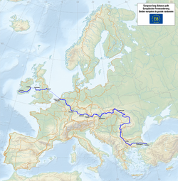
European walking route E8 is an international walking trail that extends from Dursey Island, County Cork to Istanbul in Turkey. In Ireland the E8 follows the Wicklow, South Leinster, East Munster and Blackwater Ways and parts of the Kerry and Beara Ways.[59]
↑"New walking track on Diamond Hill". The Irish Times. 6 January 2006. Retrieved 8 August 2019. With the completion of the route, the National Parks and Wildlife Service (NPWS) of the Department of the Environment lifted a three-year ban on walking on Diamond Hill, imposed because of severe erosion on the mountain.
↑Pail Cullen (25 October 2004). "Diamond Hill gets €1.4m pathway to summit". The Irish Times. Retrieved 8 August 2019. The ascent of "the Diamond" is one of the most popular climbs in Connemara. About 80,000 people visit the national park each year, and an estimated 10,000 attempt the climb.
↑Jim Ryan (1 October 2012). Scenic Walks in Killarney. Collins Press. ISBN978-1848891463. Walk 11: Torc Waterfall Circuit
↑Grace Harding (21 January 2017). "Torc Mountain". The Idyll. The combination of rocky path and sleepers will take you all the way up the summit. So unlike other mountains in Kerry, you won't need any navigation skills.
↑"Damages award to hillwalker who tripped on Wicklow Way is overturned". The Irish Times. 17 February 2017. Retrieved 6 March 2019. In a significant judgment concerning the nature of the duty of care of landowners to hillwalkers, Mr Justice Michael White found contributory negligence by Teresa Wall in relation to her fall. He rejected her arguments that a trip hazard is the same whatever the location.
↑Mary Carolan (10 March 2017). "Hill-walker stripped of €40,000 award faces legal bill". Irish Times. Retrieved 8 July 2019. Ms Wall, of Rathingle Cottages, Swords, claimed she tripped and fell after her foot snagged in a hole on a railway sleeper that was part of a boardwalk near the JB Malone memorial on the Sally Gap to Djouce trail on August 6th, 2013.
This article includes a location-related list of lists.
This page is based on this Wikipedia article Text is available under the CC BY-SA 4.0 license; additional terms may apply. Images, videos and audio are available under their respective licenses.