Related Research Articles
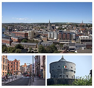
Drogheda is an industrial and port town in County Louth on the east coast of Ireland, 42 km (26 mi) north of Dublin city centre. It is located on the Dublin–Belfast corridor on the east coast of Ireland, mostly in County Louth but with the south fringes of the town in County Meath, 40 km (25 mi) north of Dublin city centre. Drogheda had a population of 44,135 inhabitants in 2022, making it the eleventh largest settlement by population in all of Ireland, and the largest town in the Republic of Ireland by both population and area. It is the last bridging point on the River Boyne before it enters the Irish Sea. The UNESCO World Heritage Site of Newgrange is located 8 km (5.0 mi) west of the town.
Slane is a village in County Meath, in Ireland. The village stands on a steep hillside on the left bank of the River Boyne at the intersection of the N2 and the N51. As of the 2022 census, Slane's population was 1,445. The village and surrounding area contains many historic sites dating back over 5,000 years. The village centre, as it is laid-out today, dates mainly from the 18th century.

The River Boyne is a river in Leinster, Ireland, the course of which is about 112 kilometres (70 mi) long. It rises at Trinity Well, Newberry Hall, near Carbury, County Kildare, and flows towards the Northeast through County Meath to reach the Irish Sea between Mornington, County Meath, and Baltray, County Louth.
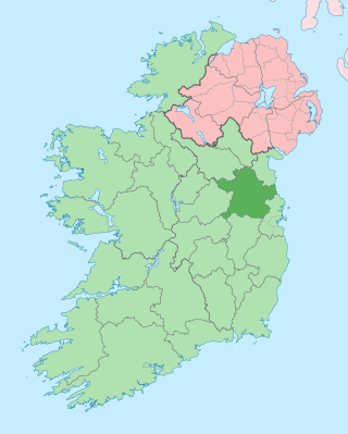
County Meath is a county in the Eastern and Midland Region of Ireland, within the province of Leinster. It is bordered by County Dublin to the southeast, Louth to the northeast, Kildare to the south, Offaly to the southwest, Westmeath to the west, Cavan to the northwest, and Monaghan to the north. To the east, Meath also borders the Irish Sea along a narrow strip between the rivers Boyne and Delvin, giving it the second shortest coastline of any county. Meath County Council is the local authority for the county.

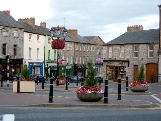
Trim is a town in County Meath, Ireland. It is situated on the River Boyne and, as of the 2022 census, had a population of 9,563. The town is noted for Trim Castle – the largest Norman castle in Ireland. One of the two cathedrals of the United Dioceses of Meath and Kildare – St Patrick's cathedral – is located north of the river. Trim won the Irish Tidy Towns Competition in 1972, 1984, 2014 and 2022, and was the joint winner with Ballyconnell in 1974. Trim was historically the county town of Meath, but this title was passed on in 1898 to the larger, neighbouring town of Navan.
Navan is the county town and largest town of County Meath, Ireland. It is at the confluence of the River Boyne and Blackwater, around 50 km northwest of Dublin. At the 2022 census, it had a population of 33,886, making it the ninth largest settlement in Ireland.

Laytown is a village in County Meath, Ireland, located on the R150 regional road and overlooking the Irish Sea. Historically it was called Ninch, after the townland it occupies. Together with the neighbouring villages of Mornington, Bettystown and Donacarney, it comprises the census town of Laytown–Bettystown–Mornington–Donacarney, which recorded a population of 15,642 in the 2022 census.

The Diocese of Meath is a Latin Church diocese of the Catholic Church that is located in the middle part of Ireland. It is one of eight suffragan dioceses of the ecclesiastical province of Armagh. Thomas Deenihan has been bishop of the diocese since 2 September 2018.

The Boyne Navigation is a series of canals running 31 km (19 mi) roughly parallel to the River Boyne from Oldbridge to Navan in County Meath, in Ireland. The navigation was once used by horse-drawn boats travelling between Navan, Slane and the port of Drogheda; however is now derelict. The Boyne Navigation branch of the Inland Waterways Association of Ireland have an agreement with An Taisce – The National Trust for Ireland giving it a license to carry out restoration work on the navigation to return it to a usable waterway.

Mornington is a coastal village on the estuary of the River Boyne in County Meath, Ireland approximately 5 km downriver from the centre of Drogheda. Together with the neighbouring villages of Laytown, Bettystown and Donacarney, it comprises the urban area of Laytown–Bettystown–Mornington–Donacarney with a combined population of 15,642 at the 2022 census.

The Dublin-Navan line is a partially-open commuter rail line between Dublin and the town of Navan in County Meath. Since September 2010, train services operate from Docklands Station to M3 Parkway, with an extension to Navan itself proposed.

Donore, historically Dunower, is a small village in County Meath, Ireland. It lies near Drogheda on the border between County Meath and County Louth, in the Boyne Valley on the road between Drogheda and the Brú na Bóinne heritage site. During the late 17th century, the village was used as a defensive position by the Jacobite army of King James II against King William III during the Battle of the Boyne (1690). The Battle of the Boyne Visitor Centre is located in the restored 18th century Oldbridge House, which is on the battle site, approximately 3 km north of Donore.
Dunshaughlin railway station is a proposed railway station intended to serve the town of Dunshaughlin in County Meath, Ireland.

Navan railway station is a former train station which served the town of Navan in County Meath, Ireland.

Duleek railway station is a former railway station that served the town of Duleek in County Meath. Located on the Drogheda-Oldcastle branch line and operated by the GNR(I), the station opened in 1850 and closed to passenger services, along with the rest of the line, in 1958.
The High Sheriff of Meath was the British Crown's judicial representative in County Meath, Ireland, from the conquest until 1922, when the office was abolished in the new Free State and replaced by the office of Meath County Sheriff.

Oldbridge is a townland near Drogheda in County Meath, Ireland. The area is home to the Boyne Navigation, the Battle of the Boyne Interpretive Centre and the southern half of the Mary McAleese Boyne Valley Bridge.

The Dublin–Galway Greenway is a partially completed 'coast-to-coast' greenway and partial rail trail, in Ireland, funded by the Department of Transport, which is due to become the western section of EuroVelo EV2, a cycle route from Galway, Ireland, crossing Europe and ending in Moscow, Russia. The 276 km route was planned to be completed by 2020. It is due to be the fourth greenway in Ireland, after the Great Southern Trail, the Great Western Greenway and the Waterford Greenway.
Ireland's greenways are off-road routes for walkers, cyclists and other non-motorised transport in Ireland, which are often created as rail trails on abandoned sections of the Irish rail network. In the Republic of Ireland, several greenway initiatives have been centrally funded by the Irish government. In Northern Ireland, greenways are typically part of the collective British National Cycle Network (NCN).

Wilkinstown is a townland and village in north County Meath, Ireland. It is located on the Yellow River and the Navan–Kingscourt road (R162) about 10 kilometres (6.2 mi) between both Navan and Nobber. Nobber is to the north, Kells is to the west, Navan at the south and Slane at the east.
References
- ↑ "Boyne Greenway". Walking with David. Archived from the original on 28 December 2014. Retrieved 27 December 2014.
- ↑ "Boyne Trail". irishgreenway.com. IrishGreenways.com. Archived from the original on 28 December 2014. Retrieved 1 January 2015.
- ↑ Spearman, Andy. "Council applies for permission for Mornington to Drogheda greenway". Drogheda Life.
- ↑ Murphy, Hubert. "More information sought on Boyne Greenway plan". Drogheda Independent. Retrieved 10 October 2021.
- ↑ Comyn, Alison (7 September 2023). "Boyne Greenway plan linking Drogheda and Mornington is rejected". Drogheda Independent. Retrieved 11 January 2024.
- ↑ McCabe, Donard (17 September 2023). "BirdWatch Ireland welcomes An Bord Pleanála decision to refuse Boyne Greenway planning". Dundalk Democrat. Retrieved 11 January 2024.
- ↑ Doyle, Simon. "Meath CoCo launch public consultation on Boyne Greenway extension". LMFM. Retrieved 10 October 2021.
- ↑ Moynihan, Ed (26 February 2021). "The Boyne Greenway Non-Statutory Public Consultation is now Open". Navan Cycling Initiative.
- ↑ Ginty, Cian (13 December 2023). "Boyne Greenway consultation welcomed after two-and-a-half-year delay -". IrishCycle.com. Retrieved 11 January 2024.

