
County Kilkenny is a county in Ireland. It is in the province of Leinster and is part of the South-East Region. It is named after the city of Kilkenny. Kilkenny County Council is the local authority for the county. As of the 2022 census the population of the county was just over 100,000. The county was based on the historic Gaelic kingdom of Ossory (Osraighe), which was coterminous with the Diocese of Ossory.
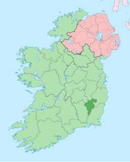
County Carlow is a county located in the South-East Region of Ireland, within the province of Leinster. Carlow is the second smallest and the third least populous of Ireland's 32 traditional counties. Carlow County Council is the governing local authority.
These are lists of long-distance trails in the Republic of Ireland, and include recognised and maintained walking trails, pilgrim trails, cycling greenways, boardwalk-mountain trails, and interconnected national and international trail systems.

The Barrow is a river in Ireland. It is one of The Three Sisters; the other two being the River Suir and the River Nore. The Barrow is the longest of the three rivers, and at 192 km (120 mi), the second-longest river in Ireland, behind the River Shannon. The catchment area of the River Barrow is 3,067 km2 before River Nore joins it a little over 20 km before its mouth. The river's long term average flow rate, again before it is joined by River Nore, is 37.4 cubic metres per second. At the merger with the River Suir, its catchment area is ca. 5,500 km2 and its discharge over 80 m3/s.
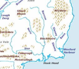
The Three Sisters are three rivers in Ireland: the River Barrow, the River Nore and the River Suir. The Suir and Nore rise in the same mountainous area in County Tipperary, near the Devil's Bit, while the Barrow rises in the Slieve Bloom Mountains in County Laois. The Nore flows into the Barrow about 17 km before the Suir and Barrow join to form an estuary called Waterford Harbour east of the city of Waterford. The rivers fan out to drain a large portion of the southern part of the island, including Counties Tipperary, Carlow, Kilkenny, Wexford and Waterford, among others.

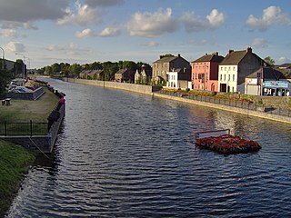
Graiguenamanagh or Graignamanagh is a town on the River Barrow in County Kilkenny, Ireland. Part of the settlement, known as Tinnahinch, is on the County Carlow side of the river, and Carlow County Council refers to the whole village as "Graiguenamanagh-Tinnahinch". Also combined for census purposes, as of the 2016 census, Graiguenamanagh-Tinnahinch had a population of 1,475 people.
The River Nore is one of the principal rivers in the South-East Region of Ireland. The 140-kilometre-long (87 mi) river drains approximately 2,530 square kilometres (977 sq mi) of Leinster and Munster, that encompasses parts of three counties. Along with the River Suir and River Barrow, it is one of the constituent rivers of the group known as the Three Sisters.

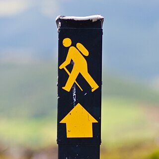
The Wicklow Way is a 131-kilometre (81-mile) long-distance trail that crosses the Wicklow Mountains in Ireland. It runs from Marlay Park in the southern suburbs of Dublin through County Wicklow and ends in the village of Clonegal in County Carlow. It is designated as a National Waymarked Trail by the Irish Sports Council and is waymarked by posts with a yellow "walking man" symbol and a directional arrow. Typically completed in 5–7 days, it is one of the busiest of Ireland's National Waymarked Trails, with up to 24,000 people a year walking the most popular sections. The Way is also used regularly by a number of mountain running competitions.

A regional road in the Republic of Ireland is a class of road not forming a major route, but nevertheless forming a link in the national route network. There are over 11,600 kilometres of regional roads. Regional roads are numbered with three-digit route numbers, prefixed by "R". The equivalent road category in Northern Ireland are B roads.

Bennettsbridge is a village in County Kilkenny in Ireland. It is situated on the River Nore 6 kilometres (3.7 mi) south of Kilkenny city, in the centre of the county. Bennettsbridge is a census town, and has population of 745 as of the 2016 census.
The Castlecomer Plateau, or 'South Leinster Coalfield', is an upland area in the North of County Kilkenny, Ireland, extending into County Laois and County Carlow at its northern edge. The plateau is bounded on the east and south by the R448 regional road, on the west by the N77. The River Nore flows southward past the plateau's western flank, the River Barrow past its eastern flank and it is dissected by the River Dinin, which flows through Castlecomer itself.

Brandon Hill is the highest mountain in County Kilkenny, Ireland, with an elevation of 515 m (1,690 ft) and prominence at 448 m (1,470 ft). The South Leinster Way, a long-distance trail, meandering through the Barrow Valley and traverses Brandon Hill. The village of Graiguenamanagh and River Barrow are at the base of the hill. It is classified as a county high point, an Arderin, a Myrddyn Dewey, and a Marilyn.
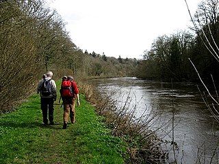
The Barrow Way is a long-distance trail in Ireland. It is 100 kilometres long and begins in Robertstown, County Kildare and ends in St Mullin's, County Carlow, following the course of the River Barrow and the Barrow Line of the Grand Canal through counties Kildare, Carlow, Kilkenny and Laois. It is typically completed in four days. It is designated as a National Waymarked Trail by the National Trails Office of the Irish Sports Council and is managed by Waterways Ireland.

The Blackwater Way is a long-distance trail that follows the valley of the River Blackwater in Ireland. It is 168 kilometres long and begins in Clogheen, County Tipperary and ends in Shrone, County Kerry. It is typically completed in ten days. It is designated as a National Waymarked Trail by the National Trails Office of the Irish Sports Council and is managed by Avondhu Tourism and IRD Duhallow. It consists of two trails – the Avondhu Way between Clogheen and Bweeng, County Cork and the Duhallow Way between Bween and Shrone – which have been combined to form the Blackwater Way.
The East Munster Way, formerly known as the Munster Way, is a long-distance trail in Ireland. It is 75 kilometres long and begins in Carrick-on-Suir, County Tipperary and ends in Clogheen, County Tipperary. It is typically completed in three days. It is designated as a National Waymarked Trail by the National Trails Office of the Irish Sports Council and is managed by Tipperary County Council, Coillte and Waterford County Council. The trail was opened by Frank Fahey, Minister of State for Youth and Sport in July 1988.
The Nore Valley Way is a long-distance trail under development in County Kilkenny, Ireland. When completed it will be 34 kilometres long and begin in Kilkenny City and end in Inistioge. It is designated as a National Waymarked Trail by the National Trails Office of the Irish Sports Council and is managed by Trail Kilkenny, a group made up of representatives of Kilkenny County Council, County Kilkenny LEADER Partnership, Kilkenny Sports Partnership and local landowners. Two stages are open at present: the first from Kilkenny to Bennettsbridge and the second from Thomastown to Inistioge. The final section – linking Bennettsbridge and Thomastown – is under construction.

St. Mullin's Upper is a barony in County Carlow, Republic of Ireland.

Gowran is a barony in the east of County Kilkenny, Ireland. The size of the barony is 430.5 square kilometres (166.2 sq mi). There are 35 civil parishes in Gowran. The chief town today is Gowran. The barony contains the ecclesiastical sites of Kilfane and Duiske Abbey The barony of Gowran is situated in the east of the county between the baronies of Fassadinin to the north, the baronies of Kilkenny, Shillelogher and Knocktopher to the west, and the barony of Ida is to the south. It borders County Carlow to the east. The M9 motorway bisects the barony.
The 2018 Leinster Senior Football Championship was the 2018 installment of the annual Leinster Senior Football Championship organised by Leinster GAA.


