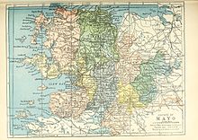
County Mayo is a county in Ireland. In the West of Ireland, in the province of Connacht, it is named after the village of Mayo, now generally known as Mayo Abbey. Mayo County Council is the local authority. The population was 137,231 at the 2022 census. The boundaries of the county, which was formed in 1585, reflect the Mac William Íochtar lordship at that time.

Croagh Patrick, nicknamed 'the Reek', is a mountain with a height of 764 m (2,507 ft) and an important site of pilgrimage in County Mayo, Ireland. The mountain has a pyramid-shaped peak and overlooks Clew Bay, rising above the village of Murrisk, several kilometres from Westport. It has long been seen as a holy mountain. It was the focus of a prehistoric ritual landscape, and later became associated with Saint Patrick, who is said to have spent forty days fasting on the summit. There has been a church on the summit since the 5th century; the current church dates to the early 20th century. Croagh Patrick is climbed by thousands of pilgrims every year on Reek Sunday, the last Sunday in July, a custom which goes back to at least the Middle Ages.

Reek Sunday, Garland Sunday or Crom Dubh Sunday is an annual day of pilgrimage in Ireland.

Westport is a town in County Mayo in Ireland. It is at the south-east corner of Clew Bay, an inlet of the Atlantic Ocean on the west coast of Ireland. Westport is a tourist destination and scores highly for quality of life. It won the Irish Tidy Towns Competition three times in 2001, 2006 and 2008. In 2012 it won the Best Place to Live in Ireland competition run by The Irish Times.

Claremorris is a town in County Mayo in the west of Ireland, at the junction of the N17 and the N60 national routes. As of the 2017, it was the fastest growing town in the county, having seen a 31% increase in population between 2006 and 2011 and a 23% increase between 2002 and 2006. Between the 2016 census and the 2022 census, the population of Claremorris grew further, from 3,687 to 3,857 inhabitants.

Clew Bay is a large ocean bay on the Atlantic coast of County Mayo, Ireland. It is roughly rectangular and has more than a hundred small islands on its landward side; Ireland's best example of sunken drumlins. The larger Clare Island guards the entrance of the bay.

Aughagower or Aghagower is a small village in rural County Mayo in western Ireland. It is 6 km south-east of Westport. Aughagower has around forty houses, a pub and a shop, with a clear view of Croagh Patrick from Reek View. It is also at the centre of Aghagower civil parish which covers an area of 86.1 square miles. The village is known for its links to Saint Patrick and Tóchar Phádraig, the pilgrimage route from Ballintubber Abbey to Croagh Patrick.

Louisburgh is a small town on the southwest corner of Clew Bay in County Mayo, Ireland. It is home to Sancta Maria College and the Gráinne O'Malley Interpretive Centre.

Lecanvey or Leckanvy is a seaside village in County Mayo, Ireland, between Westport and Louisburgh, about 2 km west of Murrisk. It has a small beach with Lecanvey Pier. To the south is Croagh Patrick. To the west is Clare Island.

Ballintubber, officially Ballintober, is a village in County Mayo, Ireland, known for Ballintubber Abbey which was founded in 1216. The countryside of Ballintubber is set against the backdrop of the Partry Mountains.

Keel is a village on Achill Island in County Mayo, Ireland.

The Archdiocese of Tuam is a Latin Church ecclesiastical territory or archdiocese of the Catholic Church located in western Ireland. The archdiocese is led by the Archbishop of Tuam, who serves as pastor of the mother church, the Cathedral of the Assumption and Metropolitan of the Metropolitan Province of Tuam. According to tradition, the "Diocese of Tuam" was established in the 6th century by St. Jarlath. The ecclesiastical province, roughly co-extensive with the secular province of Connacht, was created in 1152 by the Synod of Kells.

The R335 road is a regional road in counties Mayo and Galway in Ireland. It starts in Westport, County Mayo and ends in Leenaun, County Galway. The N59 is a much more direct route between the two towns. The R335 passes through Murrisk, Lecanvey, Louisburgh and Delphi before terminating in Leenaun. It is approximately 52 kilometres (32 mi) long with a speed limit of 80 km/h (50 mph).
Islandeady is a village in County Mayo, Ireland, about halfway between the towns of Castlebar and Westport.
The Croagh Patrick Heritage Trail is a long-distance trail in County Mayo, Ireland. It is 61 kilometres long and begins in Balla and ends in Murrisk. It is typically completed in three days. It is designated as a National Waymarked Trail by the National Trails Office of the Irish Sports Council and is managed by the Tóchar Valley Rural Community Network. It was opened by Éamon Ó Cuív, TD, Minister for Community, Rural and Gaeltacht Affairs on 6 March 2009. The trail won the runners-up prize in the Heritage category of the 2009 Co-operation Ireland Pride of Place awards.
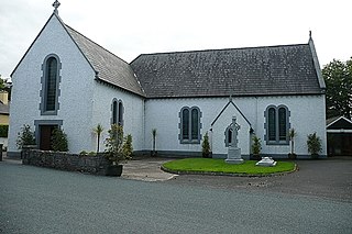
Killawalla or Killavally is a village located in County Mayo, Ireland, seven miles (10 km) from Westport on the R330 road to Ballinrobe. Saint Patrick is alleged to have passed this way en route to Croagh Patrick, and accordingly the local Catholic church is named after him. The village also contains a primary school and MacEvilly's pub established in 1968. The village post office closed in 2017. Killawalla is part of the parish of Carnacon and Ballintubber. Research carried out by NUI Maynooth showed Killawalla to have sustained the biggest population loss of any village in Ireland during the Great Famine. Between 1841 and 1851, the village lost two thirds of its population. The 1916 rising participant and sport administrator Seán O'Duffy who was heavily involved in the development of camogie in Ireland for 40 years, was born in the old barracks in Killawalla in 1886 according to a plaque erected on the wall of the school. This RIC barracks located in Kinury was one of those closed in the wake of the Tourmakeady ambush during the Irish War of Independence in May of 1921.

Murrisk Friary, is a ruined Augustinian monastery located in County Mayo, Ireland. It is on the southern coast of Clew Bay, about 10km west of Westport.

The Murrisk Millennium Peace Park is a five-acre park located north of the R335 road overlooking the Atlantic Ocean in the village of Murrisk, County Mayo, Ireland at the foot of Croagh Patrick mountain.
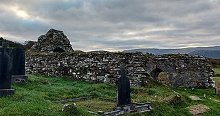
Kilgeever Abbey or church is situated just outside Louisburgh in the parish of Kilgeever, in the barony of Murrisk, County Mayo. The site consists of a ruined church, a graveyard and a holy well, where pilgrimages or patterns take place. The site is part of the Clew Bay Archaeological Trail. The church is a multi-period church containing a late medieval doorway. The graveyard on the site is suggested to be from Early Christian times and continues to be in use. Within the graveyard, there is a pillar stone incised with a cross, the graveyard also contained a free-standing stone and a portable stone cross with incised crosses which are now in private ownership.