Doohoma

Last updated

Doohoma
Dumha Thuama
Townland
The road to Dohooma Head (geograph 1878585).jpg
Road to Doohoma Head
Ireland adm location map.svg
Red pog.svg
Doohoma
Location in Ireland
Coordinates: 54°04′N9°58′W / 54.07°N 9.96°W / 54.07; -9.96
Country Ireland
Province Connacht
County County Mayo
Population
 (2016) [1]
112
Time zone UTC+0 (WET)
  Summer (DST) UTC-1 (IST (WEST))
Irish Grid Reference F719152

Doohoma or Doohooma (in Irish, and officially, Dumha Thuama) [2] is a townland, peninsula and (since 2016) a census town in the County Mayo Gaeltacht, Ireland. [3] [4] It is located on Ireland's Atlantic coastline overlooking Achill Island and the Mullet Peninsula.

Contents

Geography

Doohoma is situated on the north-west coast of Kiltane parish, Erris, County Mayo. The townland is approximately 1,075 acres (4.35 km2) in area. [5] It is situated approximately fifteen miles (24 km) south west of the village of Bangor Erris. It overlooks Achill Island and the Mullet Peninsula. The area has sea views across Blacksod Bay. Its beaches and bays are used for watersports such as surfing, kiting, sailing, swimming, fishing, boating and wind surfing.[ citation needed ]. It is part of the Mayo Gaeltacht.

Doohoma is the central village and collective name for a further six villages, which include Doohoma Head (Cean Romhar), Crook na Mona, Bunnafully, Tallaghan, Roy Carter and Roy Bingham. [6] There are two pubs, The Sea Rod Inn (Barrett's) and Tra Bui (Holmes's) and one grocery store. There are community focal points in Doohoma, including the local Roman Catholic church (Pope Pius X) and the Doohoma National School. There is also an 18-hole golf course.[ citation needed ]

History

Kite surfing on Claggan beach Kitesurfing at claggan, eris.JPG
Kite surfing on Claggan beach

Like other parts of County Mayo, Doohoma was adversely affected during the famine years of the 1840s and 1850s. The population of 455 people in 1841 was more than halved to 218 people by 1851. [7] It endured high levels of emigration throughout the years, with the diaspora of Doohoma spreading to countries including England, Scotland, the United States, Australia and Canada. The first main road through the townland was not built until 1847.

After the famine, mass burials took place on the sandbanks and, despite repeated requests by the local people for a proper cemetery, the requests were repeatedly rejected by the civil authorities.[ citation needed ] Eventually, in 1926 three hundred local men erected a sod wall, which was later consecrated by Bishop James Naughton. Eventually Mayo County Council granted some money to erect a stone wall to replace the sod ditch. Later local residents were unsuccessful in their endeavours to get a road built from the sandbanks to the cemetery, so in 1967 over 100 volunteers built a road to improve access. In 1989 the Council tarred the road for the first time.[ citation needed ]

Fishing was the main occupation of the community but did not sustain the population entirely - so every year in June whole families would go to the potato fields of Scotland.[ citation needed ][ when? ] These workers were known as "tattie hokers". There were so many who went from Doohoma, that ships would moor off Doohoma Head to transport them to the potato fields of Scotland.

The first National School was established in Doohoma in 1859 just outside the boundary of the Tallaghanbawn townland and the first church in the townland was built close by later.

A new industry was opened in the early 1970s. Eagle Isle Seafoods was founded in 1972 and became an exporter of smoked wild Atlantic salmon.

In 1987, Mayo County Council financed a two million pound water scheme. This brought piped water from Carrowmore Lake.[ citation needed ]

The townland was covered in the RTÉ documentary 'Doohoma' which dealt with the theme of emigration to England and the effect on local families. [8] In subsequent years, however, a number of first and second-generation natives returned to take advantage of the improving economic climate. [9] [10]

Doohoma was designated as a census town by the Central Statistics Office for the first time in the 2016 census, [4] at which time it had a population of 112 people. [1]

Sports

Doohoma has a football tradition.[ citation needed ] Doohoma Golf Course is a 9-hole, par-3 course overlooking the Atlantic.

Related Research Articles

<span class="mw-page-title-main">Achill Island</span> Island off the western coast of Ireland, in County Mayo

Achill Island is the largest of the Irish isles and lies off the west coast of Ireland in County Mayo. It has a population of 2,594. Its area is 148 km2 (57 sq mi). Achill is attached to the mainland by Michael Davitt Bridge, between the villages of Achill Sound and Polranny. A bridge was first completed here in 1887. Other centres of population include the villages of Keel, Dooagh, Dooega, Dooniver, and Dugort. The parish's main Gaelic football pitch and secondary school are on the mainland at Polranny. Early human settlements are believed to have been established on Achill around 3000 BC. The island is 87% peat bog. The parish of Achill consists of Achill Island, Achillbeg, Inishbiggle and the Corraun Peninsula.

<span class="mw-page-title-main">County Mayo</span> County in Ireland

County Mayo is a county in Ireland. In the West of Ireland, in the province of Connacht, it is named after the village of Mayo, now generally known as Mayo Abbey. Mayo County Council is the local authority. The population was 137,231 at the 2022 census. The boundaries of the county, which was formed in 1585, reflect the Mac William Íochtar lordship at that time.
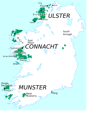
<span class="mw-page-title-main">Belmullet</span> Town in County Mayo, Ireland

Belmullet is a coastal Gaeltacht town with a population of 1,019 on the Mullet Peninsula in the barony of Erris, County Mayo, Ireland. It is the commercial and cultural heart of the barony of Erris, which has a population of almost 10,000. According to the 2016 census 50% of people in the town were able to speak Irish while only 4% spoke it on a daily basis outside the education system.

<span class="mw-page-title-main">Aughleam</span> Village in Connacht, Ireland

An Eachléim, anglicized as Aughleam or Aghleam, is a Gaeltacht village and townland in County Mayo, Ireland. It lies on the Mullet Peninsula in Erris, on the R313 regional road. It has a total area of 2.96 km2 (1.14 sq mi). Its name derives from Irish Each (horse) and Léim (leap), as local folklore has it a horse leapt from the east of the townland to the west, marking out its borders.

<span class="mw-page-title-main">Carrowteige</span> Village in Connacht, Ireland

Ceathrú Thaidhg is a Gaeltacht village and townland on the Dún Chaocháin peninsula in northwestern County Mayo, Ireland. It is within Kilcommon parish in the barony of Erris. Carrowteige is a relatively small townland with an acreage of just 403 acres (1.63 km2).

Bangor Erris is a town in Kiltane parish in Erris, County Mayo, Ireland with a population of over 300. It is on the banks of the Owenmore River and is a "gateway" to the Erris Peninsula linking Belmullet with Ballina and Westport. It is located at the foot of the "Bangor Trail" a 22-mile mountain pass across the Nephin Beg Mountain Range to Newport. Approximately 2 km away is Carrowmore Lake, Bangor is a centre for wild atlantic salmon and sea trout fishing. Bangor Erris is located in the Parish of Kiltane. Due west from Bangor are the towns of Belmullet, Geesala, Mulranny, Westport and Doolough.

<span class="mw-page-title-main">Erris</span> Barony in County Mayo, Ireland

Erris is a barony in northwestern County Mayo in Ireland consisting of over 230,452 acres (932.61 km2), much of which is mountainous blanket bog. It has extensive sea coasts along its west and north boundaries. The main towns are Belmullet and Bangor Erris. The name Erris derives from the Irish 'Iar Ros' meaning 'western promontory'. The full name is the Iorrais Domnann, after the Fir Bolg tribe, the Fir Domnann. To its north is the wild Atlantic Ocean and the bays of Broadhaven and Sruth Fada Conn and to its west is Blacksod Bay. Its main promontories are the Doohoma Peninsula, Mullet Peninsula, Erris Head, the Dún Chiortáin and Dún Chaocháin peninsulas and Benwee Head.

<span class="mw-page-title-main">Cloghane</span> Village in Munster, Ireland

An Clochán is a Gaeltacht village and townland on the Dingle Peninsula of County Kerry, Ireland, at the foot of Mount Brandon. In 1974 the village was added to the Corca Dhuibhne Gaeltacht. It has a population of 297.

<span class="mw-page-title-main">Mullet Peninsula</span> Peninsula in County Mayo, Ireland

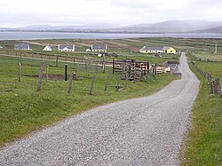
The Mullet Peninsula —also known as the Mullet and sometimes as the Erris Peninsula—is a peninsula in the barony of Erris in County Mayo, Ireland. As of 2016 it has a population of 3963. It consists of a large promontory connected to the mainland at Belmullet, a town of about 1,000 inhabitants, by a narrow isthmus. There are several villages on the Mullet peninsula including Aughleam, Elly, Corclough and Binghamstown. The Peninsula is about 33 km (21 mi) long and ranges from 200 metres (660 ft) to 12 km (7.5 mi) wide. Its northernmost point is Erris Head. The peninsula's doglegged shape forms two bays, Blacksod Bay and Broadhaven Bay.

<span class="mw-page-title-main">Cill Ghallagáin</span> Village in County Mayo, Ireland

Cill Ghallagáin is a small Gaeltacht coastal townland and village in the northwest corner of Kilcommon Parish, County Mayo, Republic of Ireland, an area of 345 hectares in size. Off the northern coast of this townland lies Kid Island, an island of 13 hectares rising on steep cliffs to a height of 95 metres (311 ft) above sea level. The island is used for grazing sheep in the summer months. Kilcommon Parish consists of two peninsulas – Dún Chaocháin and Dún Chiortáin, to the west.

<span class="mw-page-title-main">Gweesalia</span> Village in Connacht, Ireland

Gweesalia or Geesala is a small Gaeltacht village situated on the Gweesalia peninsula in the Electoral Division of Rathhill, in the Civil Parish of Kilcommon, in the Barony of Erris in western County Mayo, Ireland.

<span class="mw-page-title-main">Binghamstown</span> Townland in Connacht, Ireland

Binghamstown is a townland and village in County Mayo, Ireland. It lies on the R313 regional road on the Mullet Peninsula, near the town of Belmullet. The townland of Binghamstown has an area of approximately 3 square kilometres (1 sq mi), and had a population of 106 people as of the 2011 census. Binghamstown is in the electoral division of An Geata Mór Thuaidh.

<span class="mw-page-title-main">Corraun Peninsula</span>

The Corraun Peninsula, also spelt Currane, is a peninsula in County Mayo, on the west coast of Ireland. It extends out from the mainland towards Achill Island.

<span class="mw-page-title-main">Blacksod Bay</span> Bay of the Atlantic Ocean in Erris, Ireland

Blacksod Bay is a bay of the Atlantic Ocean in Erris, north County Mayo, Ireland. The 16 km (9.9 mi) long and 8 km (5.0 mi) wide bay is bounded on its western side by the Mullet Peninsula. Its eastern side includes Kiltane Parish, which extends southwards from Belmullet towards Gweesalia and Doohoma.

Tóin an tSeanbhaile is a small village located on the north east point of Achill Island, Ireland. It lies within the Mayo Gaeltacht.

<span class="mw-page-title-main">Dooega</span>

Dumha Éige is a village in the south west of Achill Island on the west coast of Ireland in County Mayo. It is in the Gaeltacht and is the home of Coláiste Acla. It once had a National School. The scenic area is part of the Achill Atlantic Drive. Dumha Éige/Dooega has a Blue Flag beach, a church, a pub and guesthouse.

Brian Rua (c.1648–?) was 17th century "prophet" or Oracle from Erris in County Mayo, Ireland. Papers relating to the life and the prophecies of Brian Rua, known collectively as "Tarngaireacht Bhriain Ruaidh" were destroyed, apparently by his own son, who lost his temper with his father when the two had one of their regular disagreements.

Doolough is a coastal townland covering an area of 2,493 acres (10.09 km2) in Kiltane Parish, Erris, North County Mayo, in Ireland. It is southeast of Belmullet town and is part of the Mayo Gaeltacht.

The civil parish of Kilcommon in Erris, northern County Mayo, Ireland has a total of 37 townlands: small geographic divisions of land in Ireland and Scotland's Outer Hebrides. Townlands originated in Gaelic Ireland, and predate the late-12th-century Anglo-Norman invasion. However, some townland names are derived from British plantations and Norman manors.

References

  1. 1 2 "Doohooma (Ireland) Census Town". citypopulation.de. Retrieved 12 September 2021.
  2. "Dumha Thuama / Doohooma". logainm.ie. Placenames Database of Ireland. Retrieved 17 January 2021.
  3. "Maigh Eo Thuaidh". Údarás na Gaeltachta. Retrieved 14 June 2023.
  4. 1 2 "Census of Population 2016 - Profile 2 Population Distribution and Movement". cso.ie. Central Statistics Office. Retrieved 12 September 2021. 26 new census towns were created for the 2016 Census [..including..] Doohoma
  5. "Doohooma Townland, Co. Mayo". townlands.ie.
  6. "The Sea Rod Inn - About". Thesearodinn.ie. Archived from the original on 8 March 2012. Retrieved 8 June 2013.
  7. Noone, Fr. Sean (1991). Where the Sun Sets. Naas.
  8. ""All The Men Will Be Leaving For England Again", 1972 (Extract from RTÉ archives)". RTÉ.ie . Retrieved 2020-09-07.
  9. "Geesala and Doohoma, County Mayo". Archived from the original on 6 July 2010. Retrieved 2010-05-01.
  10. "The TD, the developer and the holiday haven". Independent.ie. 22 June 2007. Retrieved 8 June 2013.

See also