Related Research Articles

Toormakeady or Tourmakeady is a Gaeltacht in south County Mayo in the west of Ireland. It is located between the shores of Lough Mask and the Partry Mountains, and covers 172.26 square kilometres (66.51 sq mi). As at the time of the 2011 census, Toormakeady had a total population of 1,007, having dropped from 1,150 in 1991. Toormakeady is also the name of the principal village in the area.

Lisdoonvarna is a spa town in County Clare in Ireland. The town is famous for its music and festivals. Although the music festival was discontinued in the 1980s, Lisdoonvarna still hosts its annual matchmaking festival each September. The population was 829 at the 2016 Census.

Tory Island, or simply Tory, is an island 14.5 kilometres off the north-west coast of County Donegal, Ireland, and is the most remote inhabited island of Ireland. The name means "place of steep rocky heights".

Camus or Camas is a small village in the Connemara Gaeltacht of County Galway, Ireland. It is between Casla and An Teach Dóite, and is divided into Camas Uachtair and Camas Íochtair, as well as several other townlands, such as Scríob, Gleann Trasna, Leitir Móir, and Doire Bhainbh.

Barna is a coastal village on the R336 regional road in Connemara, County Galway, Ireland. It has become a satellite village of Galway city. The village is Irish speaking and is therefore a constituent part of the regions of Ireland that make up the Gaeltacht.
Killagoola is a small townland lying in the civil parish of Moycullen in County Galway, Ireland. It is located about 8 miles from Galway city, just off the N59 road which travels north from Galway towards Clifden. Its name is derived from the Irish name of Cill Ogúla, which means Church on the Shoulder. Indeed there is the ruins of a small church within the boundaries of Killagoola, on the largest site in the area, Crú Hill.
Islandeady is a village in County Mayo, Ireland, about halfway between the towns of Castlebar and Westport.

Kilfane is a combination of two townlands located outside of Thomastown in County Kilkenny, Ireland. It is made up of the townlands of Kilfane East and West with a total area of 75 acres (0.30 km2). Located in the barony of Gowran, Kilfane gives its name to the wider civil parish which contains 16 townlands. It is in the Roman Catholic parish of Tullaherin.

Doohoma or Doohooma is a townland, peninsula and a census town in the County Mayo Gaeltacht, Ireland. It is located on Ireland's Atlantic coastline overlooking Achill Island and the Mullet Peninsula.
Carbery East is a barony in County Cork in Ireland. It has been split since the nineteenth century into East and West Divisions.
Carbery West is a barony in County Cork in Ireland. It has been split since the nineteenth century into East and West Divisions.
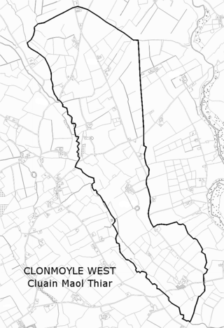
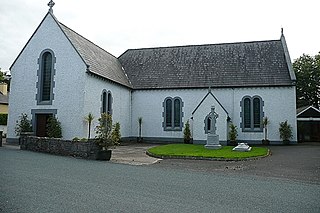
Clonmoyle West is a townland within both the civil parish and catholic parish of Aghabullogue, County Cork, Ireland. It is 774.06 acres in size, situate east of Aghabullogue village, and north-west of Coachford village.

Idrone West is a barony in County Carlow, Ireland. The early barony of Idrone was split into East and West in 1799.
Midfield is a village, in the barony of Gallen, in County Mayo, in Ireland. It is located close to the towns of Kilkelly, Kiltimagh, and Swinford, and to Ireland West (Knock) Airport.

Benglenisky at 516 metres (1,693 ft), is the 368th–highest peak in Ireland on the Arderin scale. Benglenisky is the second most southern peak, after neighbouring Benlettery, of the Twelve Bens mountain range in the Connemara National Park in Galway, Ireland, and is the lowest of the core Twelve Bens.
Castlelost West is a townland in County Westmeath, Ireland. The townland is located in the civil parish of the same name. The R446 regional road runs through the south of the area. The townland of Castlelost lies to the east and contains the town of Rochfortbridge. The town of Tyrrellspass stands to the west of the townland.
Corraveggaun West is a townland in the parish of Ballynahaglish and the barony of Tirawley, County Mayo in Ireland. It is 0.43 square miles in area and borders Corraveggaun East in the east and the village of Knockmore to the south. As of 2011, the population of the townland was 106 people in 35 occupied houses.
Lissaniska East or Lisaniska East is a tiny village and townland in the parish of Ballynahaglish and the historic barony of Tirawley, County Mayo. The townland is north of the town of Foxford, and had a population of 79 people as of the 2011 census. The local national school is Lissaniska National School.
Lisduvoge is a townland in the civil parish of Kilbelfad and the barony of Tirawley in County Mayo, Ireland. The townland is approximately 1.2 square kilometres (0.5 sq mi) in area. As of 2011, there were 76 people in 21 houses in Lisduvoge. Lough Conn Airfield, a small grass airstrip, is within the townland.
References

| | This article related to the geography of County Mayo, Ireland is a stub. You can help Wikipedia by expanding it. |