Related Research Articles

Millstreet is a town in north County Cork, Ireland, with a population of 1,555.

Dromore is a village, townland and civil parish in County Tyrone, Northern Ireland. It is nine miles (15 km) south west of Omagh on the A32 and sixteen miles (26 km) from Enniskillen. Its population as of 2008 is estimated to be 1,258.
A townland is a small geographical division of land used in Ireland and in the Western Isles in Scotland. The townland system is of Gaelic origin, pre-dating the Norman invasion, and most have names of Irish Gaelic origin. However, some townland names and boundaries come from Norman manors, plantation divisions, or later creations of the Ordnance Survey. The total number of inhabited townlands in Ireland was 60,679 in 1911. The total number recognised by the Irish Place Names database as of 2014 was 61,098, including uninhabited townlands, mainly small islands.

Creggan (Irish: creagan. is a townland in County Tyrone, Northern Ireland. It is situated in the historic barony of Omagh East and the civil parish of Termonmaguirk and covers an area of 4022 acres.

Carrickmore is a village in County Tyrone, Northern Ireland. It lies in the centre of the county on a raised site colloquially called "Carmen"; between Cookstown, Dungannon and Omagh. It is situated in the historic barony of Omagh East and the civil parish of Termonmaguirk. It had a population of 612 in the 2001 Census. In the 2011 Census 2,330 people lived in the Termon Ward, which covers the Carrickmore and Creggan areas.

Drumquin is a small village and townland in County Tyrone, Northern Ireland. It lies between Omagh and Castlederg, on the banks of the Drumquin River (Fairywater). It is situated in the civil parish of Longfield West and the historic barony of Omagh West. It had a population of 291 people in the 2001 Census.
Ballycraigy is a townland in the Civil Parish of Carnmoney in County Antrim, Northern Ireland. It is located near the Sandyknowes Junction where the A8 motorway spur diverges from the M2 motorway. The neighbouring townlands are Kingsbog, Ballyearl and Ballyhenry to the east, Ballyrobert, Carnanee and Craigarogan to the west and Ballyvesey to the south. To the north it is bordered by the Belfast to Derry railway line. The townlands is the site of the Ballycraigy Housing Estate in Antrim, south of Greystone and about ten miles (16 km) north of Belfast.

Artigarvan is a village and townland in County Tyrone, Northern Ireland. It is 3 miles from Strabane and 4 miles from Dunnamanagh, within the Strabane District Council area. It is called Airtigarvan in Ulster-Scots.
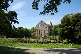
Greyabbey or Grey Abbey is a small village, townland and civil parish located on the eastern shores of Strangford Lough, on the Ards Peninsula in County Down, Northern Ireland. It lies 7 miles (11 km) south of Newtownards. Both townland and civil parish are situated in the historic barony of Ards Lower. It is within the Ards and North Down Borough. It had a population of 939 people in the 2011 Census.
Barmeen is a townland in County Antrim, Northern Ireland. It is located at the foot of Glendun, one of the nine Glens of Antrim, west of Cushendun and north of Knocknacarry. It is situated in the historic barony of Cary and the civil parish of Culfeightrin and covers 59 acres.
Groggan is a hamlet and townland near Randalstown in County Antrim, Northern Ireland. It is situated in the historic barony of Toome Upper and the civil parish of Drummaul and covers an area of 620 acres. It is within the Borough of Antrim. It had a population of 135 people in the 2011 Census.

Ballyseedy is a townland in County Kerry, Ireland. It was historically situated in the parish of Ballyseedy, within the barony of Trughanacmy. The townland contains a number of notable landmarks, including Ballyseedy Wood, a bridge over the Ballycarty River and a ruined Protestant church. There is also a large restored castle which is in use as a hotel.
Clonee is a village and a townland in County Meath, Ireland. It borders Fingal to the east at the townlands of Huntstown and Littlepace, and is sometimes used in addresses for housing in those townlands. The River Tolka passes the village.
The Census of Ireland, 1911, was a census that covered Ireland, and was conducted on Sunday 2 April 1911 as part of a broader Census of the United Kingdom. A census of Ireland had taken place every ten years beginning in 1821 until 1911. The next census did not take place until 1926 due to the Irish War of Independence and subsequent Irish Civil War. The entire returns for all 32 counties are available online on the website of the National Archives of Ireland.

Evish is a small rural community area and townland in County Tyrone, Northern Ireland, 3 miles from Strabane and 7 miles from Plumbridge. It is situated in the barony of Strabane Lower and the civil parish of Camus and covers an area of 870 acres.
Derrinturn is a village in County Kildare, Ireland. It is part of the parish of Carbury. It is located about 60 km (37 mi) from Dublin.
Cloncollow is a townland in the Parish of Tomregan, Barony of Loughtee Lower, County Cavan, Ireland.

Inishcoo is a small island and a townland off the coast of County Donegal, Ireland. The closest town on the mainland is Burtonport.

Inishturk is a small island and a townland of County Galway, in Ireland. The island is also referred as Inishturk South in order to tell it apart from the Inishturk island located in County Mayo.
Carlanstown is a village and townland in County Meath, Ireland. It is located approximately 4 km northeast of the larger town of Kells, County Meath on the N52 road. As of the 2016 census, there were 664 people living in the village.