
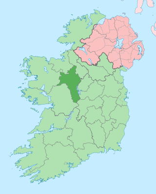
County Mayo is a county in Ireland. In the West of Ireland, in the province of Connacht, it is named after the village of Mayo, now generally known as Mayo Abbey. Mayo County Council is the local authority. The population was 137,231 at the 2022 census. The boundaries of the county, which was formed in 1585, reflect the Mac William Íochtar lordship at that time.
County Roscommon is a county in Ireland. It is part of the province of Connacht and the Northern and Western Region. It is the 11th largest Irish county by area and 27th most populous. Its county town and largest town is Roscommon. Roscommon County Council is the local authority for the county. The population of the county was 69,995 as of the 2022 census.

Westport is a town in County Mayo in Ireland. It is at the south-east corner of Clew Bay, an inlet of the Atlantic Ocean on the west coast of Ireland. Westport is a tourist destination and scores highly for quality of life. It won the Irish Tidy Towns Competition three times in 2001, 2006 and 2008. In 2012 it won the Best Place to Live in Ireland competition run by The Irish Times.

Castlebar is the county town of County Mayo, Ireland. Developing around a 13th-century castle of the de Barry family, from which the town got its name, the town now acts as a social and economic focal point for the surrounding hinterland. With a population of 13,054 in the 2022 census, Castlebar was one of the fastest growing towns in Ireland in the early 21st century.
Newport, historically known as Ballyveaghan and for many years also known as Newport-Pratt, is a small town in the barony of Burrishoole, County Mayo, Ireland. The population was 626 in 2016. It is located on the west coast of Ireland, along the shore of Clew Bay, north of Westport. The N59 road passes through the town. The county town of Castlebar is approx 18 km east of Newport. The Black Oak River flows through the centre of the town and there are walking paths along its banks.

The N5 road is a national primary road in Ireland, connecting Longford town with Westport. It is the main access route from Dublin to most of County Mayo, including the county's largest towns, Castlebar, Ballina, and Westport.

Foxford is a town 16 km south of Ballina in County Mayo, Ireland. It stands on the N26 national primary route from Swinford to Ballina and has a railway station served by trains between Manulla Junction and Ballina.

The Western Way is a long-distance trail in Ireland. It is 179 kilometres long and begins in Oughterard, County Galway and ends in Ballycastle, County Mayo. It is typically completed in seven days. It is designated as a National Waymarked Trail by the National Trails Office of the Irish Sports Council and is managed by Coillte, Galway County Council, Mayo County Council, South Mayo Development Company and Mayo North & East Development Company.

Kilkelly is a small village in Kilmovee civil parish, County Mayo, Ireland. It is just south of Ireland West Airport Knock on the N17, a national primary road running between Galway and Sligo.

The N59 road is a national secondary road in Ireland. It commences in County Sligo, south of Sligo Town at the Belladrehid interchange with the N4 north of Ballysadare. The route circles around the west of Ireland, passing west from Sligo into County Mayo and through Ballina. The N59 continues around Mayo, proceeding indirectly to Westport. Continuing south through Mayo into County Galway, the road passes through the village of Leenaun. The 182-year-old bridge in the centre of the village, carrying the road across the River Lahill, collapsed in floods on 18 July 2007. Due to the local terrain and road network, the diversionary route for getting from the south of the village to Westport was 110 km long. A temporary bridge was opened eight days after the floods, on 27 July. It has since been replaced by a new bridge.
Glenhest is a small village in County Mayo, Ireland. It is located near Lough Beltra and the Nephin Mountains.

Mulranny —sometimes spelled as 'Mallaranny', 'Mulrany', 'Malaranny', 'Mullaranny', 'Mullranny' or 'Mulranny'—is a seaside village on the isthmus between Clew Bay and Blacksod Bay in County Mayo, Ireland. Mulranny, located at the foot of the Nephin Mountain Range, has a number of blue flag beaches and a coastal lagoon. The Corraun Peninsula, which contains three mountain peaks, is situated across Clew Bay.

Binghamstown is a townland and village in County Mayo, Ireland. It lies on the R313 regional road on the Mullet Peninsula, near the town of Belmullet. The townland of Binghamstown has an area of approximately 3 square kilometres (1 sq mi), and had a population of 106 people as of the 2011 census. Binghamstown is in the electoral division of An Geata Mór Thuaidh.
Ballyglass is a small village in central County Mayo in Ireland. It is situated about 10 miles from Castlebar, and closer to Claremorris and Ballinrobe.

Cogaula is a townland in the civil parish of Islandeady, County Mayo, Ireland. The townland has an area of approximately 1.5 square kilometres (0.58 sq mi), and had a population of 74 people as of the 2011 census.

Dumha Éige is a village in the south west of Achill Island on the west coast of Ireland in County Mayo. It is in the Gaeltacht and is the home of Coláiste Acla. It once had a National School. The scenic area is part of the Achill Atlantic Drive. Dumha Éige/Dooega has a Blue Flag beach, a church, a pub and guesthouse.

Irishtown is a village in County Mayo, Ireland, located on the southern county border with County Galway about halfway between Claremorris and Tuam on the R328 regional road. Irishtown is in the Civil Parish of Crossboyne, Barony of Clanmorris and the Catholic Diocese of Tuam. It is sometimes referred to as 'The Cradle of the Land League' due to its connections with the founding of the Irish National Land League.
Killawalla or Killavally is a village located in County Mayo, Ireland, seven miles (10 km) from Westport on the R330 road to Ballinrobe. Saint Patrick is alleged to have passed this way en route to Croagh Patrick, and accordingly the local Catholic church is named after him. The village also contains a primary school and MacEvilly's pub established in 1968. The village post office closed in 2017. Killawalla is part of the parish of Carnacon and Ballintubber. Research carried out by NUI Maynooth showed Killawalla to have sustained the biggest population loss of any village in Ireland during the Great Famine. Between 1841 and 1851, the village lost two thirds of its population. The 1916 rising participant and sport administrator Seán O'Duffy who was heavily involved in the development of camogie in Ireland for 40 years, was born in the old barracks in Killawalla in 1886 according to a plaque erected on the wall of the school. This RIC barracks located in Kinury was one of those closed in the wake of the Tourmakeady ambush during the Irish War of Independence in May of 1921.

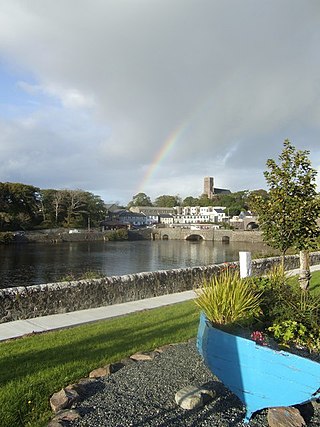
Ballina is a town in north County Mayo, Ireland. It lies at the mouth of the River Moy near Killala Bay, in the Moy valley and Parish of Kilmoremoy, with the Ox Mountains to the east and the Nephin Beg mountains to the west. The town occupies two baronies; Tirawley on the west bank of the Moy River, and Tireragh, a barony within County Sligo, on its east banks. At the 2022 census, the population of Ballina was 10,556.

Atlantic Technological University is a technological university in the west and north-west of Ireland. It was formally established on 1 April 2022 as a merger of three existing institutes of technology (ITs) – Galway-Mayo IT, IT Sligo, and Letterkenny IT – into a single university, the fourth such TU in Ireland.

