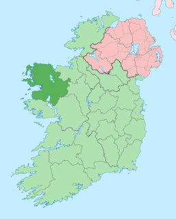
County Mayo is a county in Ireland. In the West of Ireland, in the province of Connacht, it is named after the village of Mayo, now generally known as Mayo Abbey. Mayo County Council is the local authority. The population was 130,507 at the 2016 census. The boundaries of the county, which was formed in 1585, reflect the Mac William Íochtar lordship at that time.

Castlebar is the county town of County Mayo, Ireland.

Carrigallen is a small village in County Leitrim, Ireland. It is located on the R201 and R203 roads in the east of the county. As of 2016, the village had a population of 387.

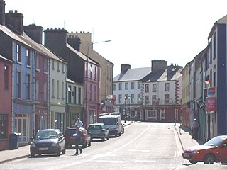
Ballycastle is a village in County Mayo, Ireland, situated northwest from Ballina, near Mayo's north coast. It lies on the edge of the Mayo Gaeltacht.

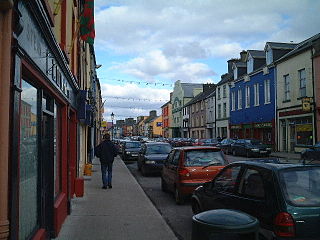
Killala is a village in County Mayo in Ireland, north of Ballina. The railway line from Dublin to Ballina once extended to Killala. To the west of Killala is a Townsplots West, which contains a number of ancient forts.

Lough Conn is a lake in County Mayo, Ireland. With an area of about 48 square kilometres (19 sq mi), it is Ireland's seventh largest lake. With its immediate neighbour to the south, Lough Cullin, it is connected to the Atlantic Ocean by the River Moy. Lough Conn is noted for its trout and salmon fishing. The ruins of a priory exist at Errew Abbey.

Ballinrobe is a town in County Mayo in Ireland. It is located on the River Robe, which empties into Lough Mask two kilometres to the west. As of the 2016 census, the population was 2,786.
Swinford is a town in County Mayo, Ireland. It is surrounded by a number of smaller villages, including Midfield and Meelick. It is just off the N5 road, located 18 km (11 mi) from Ireland West Airport Knock. Situated on a tributary of the River Moy, Swinford is known for its fishing waters, including the Callow lakes and the lakes of Conn and Cullin. Swinford was bypassed in 1993 by the N5 route and was the first town in Mayo to be bypassed.

Ballindine is a village in County Mayo, Ireland. It is located along the Western Railway Corridor, 6.5 km (4 miles) south of Claremorris. The N17 road passes through the village, carrying over 10,000 vehicles daily, and it connects to the R328 road on the south side of town.

Charlestown is a town in County Mayo, Ireland, on the N17 road near its junction with the N5.

Kilkelly is a small village in Kilmovee parish County Mayo, Ireland. It is just south of Ireland West Airport Knock on the N17, a national primary road running between Galway and Sligo.
Kiltimagh is a town in County Mayo in Ireland. As of the 2016 census, the town had a population of 1,069 people. Although there in no river going through the town, three rivers flow around the town: the Glore River, Yellow River and Pollagh River. The town centre sits at the crest of a hill surrounding The High Fort in Fortlands and built out linearly on the main road from there.

Mayo or Mayo Abbey is a village in County Mayo, Ireland. Although it bears the same name as the county, it is not the county seat, which is Castlebar. Mayo Abbey is a small historic village in south Mayo approximately 16 km to the south of Castlebar and 10 km north west of Claremorris.

Glenhest is a small village in County Mayo, Ireland. It is located near Lough Beltra and the Nephin Mountains.
Meelick is a small village situated some 5 km west-southwest of Swinford in County Mayo, Ireland.

Corroy is a village in County Mayo in Ireland. It lies on the R310 regional road between the town of Ballina and the village of Knockmore in the Parish of Backs.

Irishtown is a village in County Mayo, Ireland, located on the southern county border with County Galway about halfway between Claremorris and Tuam on the R328 regional road. Irishtown is in the Civil Parish of Crossboyne, Barony of Clanmorris and the Catholic Diocese of Tuam. It is sometimes referred to as 'The Cradle of the Land League' due to its connections with the founding of the Irish National Land League.

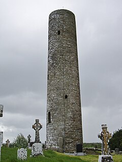
Errew Abbey is a former Augustinian monastery and National Monument located in County Mayo, Ireland.

Templenagalliaghdoo is a medieval church and National Monument in County Mayo, Ireland.
Midfield is a village, in the barony of Gallen, in County Mayo, in Ireland. It is located close to the towns of Kilkelly, Kiltimagh, and Swinford, and to Ireland West (Knock) Airport.


