Connacht or Connaught, is one of the four provinces of Ireland, in the west of Ireland. Until the ninth century it consisted of several independent major Gaelic kingdoms.
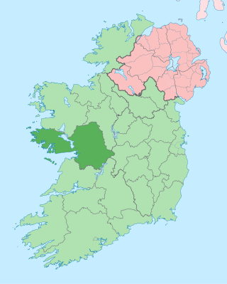
County Galway is a county in Ireland. It is in the Northern and Western Region, taking up the south of the province of Connacht. The county population was 276,451 at the 2022 census.
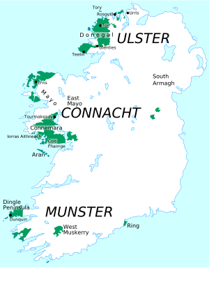
A Gaeltacht is a district of Ireland, either individually or collectively, where the Irish government recognises that the Irish language is the predominant vernacular, or language of the home. The Gaeltacht districts were first officially recognised during the 1920s in the early years of the Irish Free State, following the Gaelic revival, as part of a government policy aimed at restoring the Irish language.

Toormakeady or Tourmakeady is a Gaeltacht in south County Mayo in the west of Ireland. It is located between the shores of Lough Mask and the Partry Mountains, and covers 172.26 square kilometres (66.51 sq mi). As at the time of the 2011 census, Toormakeady had a total population of 1,007, having dropped from 1,150 in 1991. Toormakeady is also the name of the principal village in the area.

Castlebar is the county town of County Mayo, Ireland. Developing around a 13th-century castle of the de Barry family, from which the town got its name, the town now acts as a social and economic focal point for the surrounding hinterland. With a population of 13,054 in the 2022 census, Castlebar was one of the fastest growing towns in Ireland in the early 21st century.
Ballyhaunis is a town in County Mayo, Ireland. It is at the crossroads of the N60 and N83 National secondary roads and on the railway line linking Dublin to Westport and Ballina.

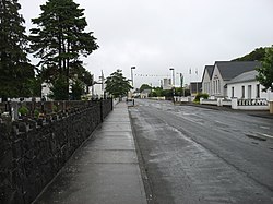
Claremorris is a town in County Mayo in the west of Ireland, at the junction of the N17 and the N60 national routes. As of the 2017, it was the fastest growing town in the county, having seen a 31% increase in population between 2006 and 2011 and a 23% increase between 2002 and 2006. Between the 2016 census and the 2022 census, the population of Claremorris grew further, from 3,687 to 3,857 inhabitants.
Tournafulla, or Toornafulla, is a village in the southwest of County Limerick, Ireland. Tournafulla is a long single-street village. It has a Catholic church, a primary school, three pubs, a community hall and a GAA pitch. As of the 2022 census, the village had a population of 204 people.
Lahardane, also sometimes spelled Lahardaun, is a village in the parish of Addergoole, County Mayo, Ireland, adjacent to Lough Conn and to Nephin, and close to the towns of Crossmolina, Castlebar and Ballina. The 2016 census recorded a population of 178.

Ballindine is a village in County Mayo, Ireland. It is located along the Western Railway Corridor, 6.5 km (4 miles) south of Claremorris. The N17 road passes through the village, carrying over 10,000 vehicles daily, and it connects to the R328 road on the south side of town.

Moycullen is a Gaeltacht village in County Galway, Ireland, about 10 km (7 mi) northwest of Galway city. It is near Lough Corrib, on the N59 road to Oughterard and Clifden, in Connemara. Moycullen is now a satellite town of Galway with some residents commuting to the city for work, school, and business. Population increased 33.7% from the 2016 census, reaching 2,279 in 2022.
James Daly was an Irish nationalist activist best known for his work in support of tenant farmers' rights and the formation of the Irish National Land League.

Ballindrait is a townland, village and census town in County Donegal, Ireland. Located near Lifford, the village and townland of Ballindrait is in the civil parish of Clonleigh and the barony of Raphoe North. The Burn Dale flows through the centre of Ballindrait.
Annaghdown is a civil parish in County Galway, Ireland. It lies around Annaghdown Bay, an inlet of Lough Corrib. Villages in the civil parish include Corrandulla and Currandrum. Annaghdown is also an ecclesiastical parish in the Roman Catholic Archdiocese of Tuam and the Church of Ireland Diocese of Tuam, Killala and Achonry.

Doohoma or Doohooma is a townland, peninsula and a census town in the County Mayo Gaeltacht, Ireland. It is located on Ireland's Atlantic coastline overlooking Achill Island and the Mullet Peninsula.

Abbeyknockmoy is a village and parish in County Galway, Ireland. It is known for the nearby ruins of the 12th century Cistercian abbey, established with the Kings of Connacht as its benefactors. The abbey was the burial site of King Cathal Crobhdearg Ua Conchobair and contains several examples of medieval wall paintings and sculpture. It was formerly part of the kingdom of the Soghain of Connacht.
Moycullen GAA is a group title for several Gaelic Athletic Association clubs based in Moycullen, County Galway. The three clubs, Cumann Peile Mhaigh Cuilinn, Cumann Iománaíocht Maigh Cuilinn and Cumann Camógaíocht Mhaigh Cuilinn share playing facilities and cooperate on a number of the local community and sporting issues. The clubs are members of the Galway GAA. There are two other clubs in the parish with indirect GAA affiliations, Moycullen Ladies Football Club and Moycullen Handball Club, who also share the club facilities.

Baile Ghib is a small village and Gaeltacht in County Meath, Ireland. It is about 70km northwest of Dublin city.
Davitts GAA is a Gaelic Athletic Association club based in the parish of Kilvine in south County Mayo, Ireland.

Ballinabranna or Ballinabrannagh is a small village in County Carlow, Ireland. It is located approximately 8 kilometres south of Carlow and 5 kilometres from Junction 6 of the M9 motorway. It is within the townland of Ballinabrannagh, and is in the barony of Idrone West. As of the 2016 census, the population of the village was 466.