Related Research Articles

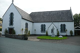
Toormakeady or Tourmakeady is a Gaeltacht in south County Mayo in the west of Ireland. It is located between the shores of Lough Mask and the Partry Mountains, and covers 172.26 square kilometres (66.51 sq mi). As at the time of the 2011 census, Toormakeady had a total population of 1,007, having dropped from 1,150 in 1991. Toormakeady is also the name of the principal village in the area.
A townland is a small geographical division of land, historically and currently used in Ireland and in the Western Isles in Scotland, typically covering 100–500 acres (40–202 ha). The townland system is of Gaelic origin, antedating the Norman invasion, and most have names of Irish origin. However, some townland names and boundaries come from Norman manors, plantation divisions, or later creations of the Ordnance Survey. The total number of inhabited townlands in Ireland was 60,679 in 1911. The total number recognised by the Irish Place Names database as of 2014 was 61,098, including uninhabited townlands, mainly small islands.
Hollymount is a village on the R331 regional road in County Mayo, Ireland. It lies midway between the towns of Ballinrobe and Claremorris in the plains of south Mayo. It has a post office, a mini-mart, a community centre, a small fuel/petrol station, and various public houses. It also has a Gaelic Athletic Association pitch and health clinic. It has a population of approximately 60 residents.

Erris is a barony in northwestern County Mayo in Ireland consisting of over 230,452 acres (932.61 km2), much of which is mountainous blanket bog. It has extensive sea coasts along its west and north boundaries. The main towns are Belmullet and Bangor Erris. The name Erris derives from the Irish 'Iar Ros' meaning 'western promontory'. The full name is the Iorrais Domnann, after the Fir Bolg tribe, the Fir Domnann. To its north is the wild Atlantic Ocean and the bays of Broadhaven and Sruth Fada Conn and to its west is Blacksod Bay. Its main promontories are the Doohoma Peninsula, Mullet Peninsula, Erris Head, the Dún Chiortáin and Dún Chaocháin peninsulas and Benwee Head.

Gweesalia or Geesala is a small Gaeltacht village situated on the Gweesalia peninsula in the Electoral Division of Rathhill, in the Civil Parish of Kilcommon, in the Barony of Erris in western County Mayo, Ireland.

Kilcummin is a beachhead and civil parish on the northern coast of County Mayo in Ireland. Traditionally a fishing community, the Kilcummin area is sparsely populated. The "Tír Sáile - North Mayo Sculpture Trail" and "Tour d'Humbert" tourist route lead through the area. Kilcummin overlooks Killala Bay, the blue flag beach "An Trá nRoss", "Bartra Island" and lies on the opposite shore to Enniscrone and its beach in County Sligo.

Binghamstown is a townland and village in County Mayo, Ireland. It lies on the R313 regional road on the Mullet Peninsula, near the town of Belmullet. The townland of Binghamstown has an area of approximately 3 square kilometres (1 sq mi), and had a population of 106 people as of the 2011 census. Binghamstown is in the electoral division of An Geata Mór Thuaidh.

Costello is one of the ancient baronies of Ireland. Unusually for an Irish barony, it straddles two counties: County Mayo and County Roscommon. It comprises the modern day districts of Kilkelly, Kilmovee, Killeagh, Kilcolman, and Castlemore.
Glencastle is a small village in the northwest of County Mayo, Ireland. The townland incorporates an area of 2,336 acres (9.45 km2).

Corroy is a village in County Mayo in Ireland. It lies on the R310 regional road between the town of Ballina and the village of Knockmore in the Parish of Backs.
Islandeady is a village in County Mayo, Ireland, about halfway between the towns of Castlebar and Westport.

Glengad is a Gaeltacht village in the parish of Kilcommon in northwest County Mayo, Ireland. It is also known as Dooncarton, a name which comes from an Iron Age tribal chieftain called Ciortan, a character who appears in the Ulster Cycle legend of the Táin Bó Flidhais.

Doohoma or Doohooma is a townland, peninsula and a census town in the County Mayo Gaeltacht, Ireland. It is located on Ireland's Atlantic coastline overlooking Achill Island and the Mullet Peninsula.

Cogaula is a townland in the civil parish of Islandeady, County Mayo, Ireland. The townland has an area of approximately 1.5 square kilometres (0.58 sq mi), and had a population of 74 people as of the 2011 census.
Barroosky is a townland within the civil parish of Kilcommon in the County of Mayo, Ireland. It is located within the parish of Kilcommon-Erris.
Midfield is a village, in the barony of Gallen, in County Mayo, in Ireland. It is located close to the towns of Kilkelly, Kiltimagh, and Swinford, and to Ireland West (Knock) Airport.
Forrew is a townland in the civil parish of Moygownagh and historical barony of Tirawley, County Mayo, Ireland. The townland, which is approximately 1.1 square miles (2.8 km2) in area, had a population of 7 people as of the 2011 census. Forrew Bog, a natural heritage peatland, is partially within the townland.
Lissaniska West is a townland in the parish of Ballynahaglish and the historical barony of Tirawley, County Mayo. The townland is north of the town of Foxford, the townland of Lissaniska East, south of the town of Ballina and the population had 81 people in 23 dwellings within the townland.
Lisduvoge is a townland in the civil parish of Kilbelfad and the barony of Tirawley in County Mayo, Ireland. The townland is approximately 1.2 square kilometres (0.5 sq mi) in area. As of 2011, there were 76 people in 21 houses in Lisduvoge. Lough Conn Airfield, a small grass airstrip, is within the townland.
References
- 1 2 "Derrycorrib Townland, Co. Mayo". www.townlands.ie. Retrieved 2023-06-22.
- ↑ https://data.gov.ie/dataset/cd164-mayo-population-by-private-households-occupied-and-vacancy-rate?package_type=dataset
