
Balbriggan is a coastal town in Fingal, in the northern part of the former County Dublin, Ireland, approximately 34 km north of Dublin City. The 2016 census population was 21,722 for Balbriggan and its environs.

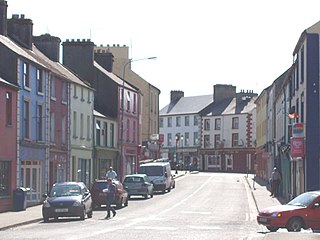
Westport is a town in County Mayo in Ireland. It is at the south-east corner of Clew Bay, an inlet of the Atlantic Ocean on the west coast of Ireland. Westport is a tourist destination and scores highly for quality of life. It won the Irish Tidy Towns Competition three times in 2001, 2006 and 2008. In 2012 it won the Best Place to Live in Ireland competition run by The Irish Times.

Claremorris is a town in County Mayo in the west of Ireland, at the junction of the N17 and the N60 national routes. It is the fastest growing town in the county. There was a 31% increase in the town's population between 2006 and 2011 and a 23% increase between 2002 and 2006. The population of Claremorris in the 2016 Census was 3,687, rising from 3,412 in the 2011 Census.

Ballon is a village in County Carlow, Ireland. It is located on the N80 road near Carlow town.
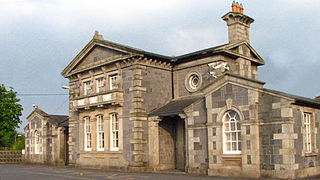
Bagenalstown, officially named Muine Bheag, is a small town on the River Barrow in County Carlow, Ireland.

Monamolin or Monamoling is a small rural village in County Wexford, Ireland, about 11 km (6.8 mi) south of the town of Gorey.
Swinford is a town in County Mayo, Ireland. It is surrounded by a number of smaller villages, including Midfield and Meelick. It is just off the N5 road, located 18 km (11 mi) from Ireland West Airport Knock. Situated on a tributary of the River Moy, Swinford is known for its fishing waters, including the Callow lakes and the lakes of Conn and Cullin. Swinford was bypassed in 1993 by the N5 route and was the first town in Mayo to be bypassed.

Ballindine is a village in County Mayo, Ireland. It is located along the Western Railway Corridor, 6.5 km (4 miles) south of Claremorris. The N17 road passes through the village, carrying over 10,000 vehicles daily, and it connects to the R328 road on the south side of town.

Monivea is a village in County Galway, Ireland. It is located approximately 30 km from Galway City and 9 km from Athenry.

Gowran is a town located on the eastern side of County Kilkenny, Ireland. The historic St. Mary's Collegiate Church is located in the centre of Gowran close to Gowran Castle. Gowran Park race course and Golf Course are located one km from the centre of Gowran. Gowran is located on the R448 regional road where it is crossed by the R702 regional road.
Carra is one of the nine baronies of County Mayo in Ireland, located in the mid-south area of the county. It is sometimes known as Burriscarra. It incorporates the town of Castlebar, the villages of Tourmakeady, Belcarra and Turlough, where the National Museum of Country Life is situated.

Straid is a small village in County Antrim, Northern Ireland, about three miles east of Ballyclare, and about six miles inland from Carrickfergus. It lies at the centre of the townland of Straidlands, in the Civil Parish of Ballynure within the Antrim and Newtownabbey Borough Council area, and in the former barony of Belfast Lower. The village has a congregational church, an Orange hall, and a primary school.
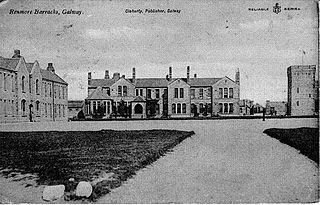
Renmore is a suburb of Galway City, Ireland, situated approximately 2 km to the east of the city. Renmore runs east along the coast and south of Dublin Road, from the shore of Lough Atalia on its west side to Lurgan Park on its east. The area houses approximately 5,000 people and includes Ballyloughane beach, which also has camping facilities.
Drummin is a small village in County Mayo, Ireland, near the town of Westport.
Corrimbla or Corimla is an area approximately 4 kilometres (2.5 mi) east/north-east of Ballina, County Mayo in Ireland. It comprises two townlands, Corimla North and Corimla South.
Belcarra is a village in County Mayo, Ireland about 10 kilometres (6.2 mi) south-east of the county town of Castlebar.

Fennagh, local name Fenagh is a village in County Carlow, Ireland. It lies on the R724 regional road between Muine Bheag (Bagenalstown) and Myshall.
Ballyglass is a small village in central County Mayo in Ireland. It is situated about 10 miles from Castlebar, and closer to Claremorris and Ballinrobe.

Ballina is a town in north County Mayo, Ireland. It lies at the mouth of the River Moy near Killala Bay, in the Moy valley and Parish of Kilmoremoy, with the Ox Mountains to the east and the Nephin Beg mountains to the west. The town occupies two baronies; Tirawley on the west bank of the Moy River, and Tireragh, a barony within the County of Sligo, on its east banks. As of 2016, the population of Ballina was 10,171.
Bonniconlon GAA is a Gaelic football club located in the north County Mayo, Ireland. Based in the village of Bonniconlon, the club participates in competitions organised by the Mayo GAA county board.

