Souterrain

Last updated
Neolithic souterrain on Canna Island, Hebrides Neolithic souterrain Canna Island.jpg
Neolithic souterrain on Canna Island, Hebrides
Panoramic view of a souterrain contemporary with a ringfort dating to around 700 AD, built within a much earlier barrow cemetery, in County Armagh, Northern Ireland Killaltarpanojpg.jpg
Panoramic view of a souterrain contemporary with a ringfort dating to around 700 AD, built within a much earlier barrow cemetery, in County Armagh, Northern Ireland

Souterrain (from French sous terrain, meaning "under ground") is a name given by archaeologists to a type of underground structure associated mainly with the European Atlantic Iron Age.

Contents

These structures appear to have been brought northwards from Gaul during the late Iron Age. Regional names include earth houses, fogous and Pictish houses. The term souterrain has been used as a distinct term from fogou meaning 'cave'. [1] In Cornwall the regional name of fogou (Cornish for 'cave') is applied to souterrain structures. [2] [3] The design of underground structures has been shown to differ among regions; for example, in western Cornwall the design and function of the fogou appears to correlate with a larder use. [4]

Etymology

The name souterrain comes from the French language (sous-terrain or souterrain), in which it means "underground passageway" or refers to subterranea in general. In languages other than English, it is sometimes used to mean "basement", especially in warehouses, or semi-basement.

Construction and suggested purpose

Plan and sections of an earth-house at Kildrummy, Aberdeenshire Earth house Kildrummy Anderson 1883 scotlandinpagant00andeiala 0314.jpg
Plan and sections of an earth-house at Kildrummy, Aberdeenshire

Souterrains are underground galleries and, in their early stages, were always associated with a settlement. The galleries were dug out and then lined with stone slabs or wood before being reburied. In cases where they were cut into rock this was not always necessary. They do not appear to have been used for burial or ritual purposes and it has been suggested that they were food stores or hiding places during times of strife, although some of them would have had very obvious entrances. [5]

Examples

Brechin

An example of a wood-lined Iron Age souterrain with a possible water tank was excavated in 2016 at Brechin Farm, Angus by Headland Archaeology. It was 15 metres (50 feet) in total length and was constructed in a 'C' shape with two distinct chambers. A linear ditch was located immediately adjacent to the souterrain and was connected to the southwest chamber by a tunnel. This tunnel sloped gently downwards towards the chamber and its edges were iron-panned, indicating that water had run through it for a significant amount of time. This indicates the southwest chamber was used as some kind of water collection and storage system. The soil into which the souterrain was dug was soft sand that would have been impossible to maintain without a lining; the presence of stake holes along the edge of the northeast chamber and the lack of stones means that the walls would have been wood-lined. Radiocarbon dating suggests occupation between the 1st and 3rd centuries AD. [6]

Rosal

An example of an excavated souterrain is the site at Rosal, Strathnaver, Sutherland. [7] In this excavation, no artefacts or other finds were made inside the structure and the roof may have been only partially covered with stones, a timber roof being present on part of it. It was suggested that the souterrain could have been used as a byre or barn and it was associated with an abandoned settlement.

Castle Bloody

An example of a partially explored souterrain in northern Scotland, on Shapinsay in the Orkney Islands is Castle Bloody, situated near the seacoast. [8] Another example has been excavated in Perthshire near Alyth. [9]

In Scotland some souterrains may be connected with the same people who built brochs.

Newtownbalregan

A well-illustrated account of a souterrain excavated at Newtownbalregan, County Louth, one of the many souterrains discovered during a road-building project in Ireland, may be found in Archaeology Ireland Winter 2003 issue. [10]

Farrandreg

A full report on the excavation of a three-level souterrain at Farrandreg, County Louth, in 1998 gives references for the 14 souterrains previously excavated in this souterrain-rich county. [11] Finds included a rotary quern-stone (a grinding stone), a bone comb, a copper-alloy stick pin, three bone needles and the greater part of a tub-shaped pottery vessel in ‘Souterrain ware.’ Based on the finds, the excavator concluded the souterrain had been closed up in the 12th century.

Other Irish souterrains

Souterrains often are referred to in Ireland simply as ‘caves.’ A. T. Lucas, a folklorist and director of the National Museum of Ireland in the 1960s, published a series of articles on the references to souterrains in the early Irish annals. [12] Donaghmore Souterrain, discovered in County Louth in 1960, and Drumlohan Souterrain in County Waterford are the only souterrains to be an Irish National Monument.

In Ireland, souterrains often are found inside or in close proximity to a ringfort and as such are thought to be mainly contemporary with them, making them somewhat later in date than in other countries. This date is reinforced by many examples where ogham stones dating to around the 6th century have been reused as roofing lintels or door posts, most notably at the widened natural limestone fissure at the ‘Cave of the Cats’ in Rathcrogan. The distribution of souterrains is very uneven in Ireland, with the greatest concentrations occurring in north Louth, north Antrim, south Galway, and west Cork and Kerry. Lesser numbers are found in counties Meath, Westmeath, Mayo, north Donegal, and Waterford. Other counties, such as Limerick, Carlow, and Wexford, are almost completely lacking in examples. [13]

An article by Warner on the archaeology of souterrains, although published 44 years ago, still is possibly the best general overview of the subject. [14]

The most comprehensive study of Irish souterrains is M. Clinton's 2001 work, containing chapters on distribution, associated settlements, function, finds, chronology and 13 appendices on various structural aspects of souterrains. [13]

A short summary account of souterrains in Ireland appeared in the quarterly magazine Archaeology Ireland in 2004. [15]

See also

Related Research Articles

<span class="mw-page-title-main">Angus, Scotland</span> Council area of Scotland

Angus is one of the 32 local government council areas of Scotland, a registration county and a lieutenancy area. The council area borders Aberdeenshire, Dundee City and Perth and Kinross. Main industries include agriculture and fishing. Global pharmaceuticals company GSK has a significant presence in Montrose in the north of the county.

<span class="mw-page-title-main">Crannog</span> Prehistoric lake dwelling

A crannog is typically a partially or entirely artificial island, usually built in lakes and estuarine waters of Scotland, Wales, and Ireland. Unlike the prehistoric pile dwellings around the Alps, which were built on the shores and not inundated until later, crannogs were built in the water, thus forming artificial islands.

<span class="mw-page-title-main">Chysauster Ancient Village</span>

Chysauster Ancient Village is a late Iron Age and Romano-British village of courtyard houses in Cornwall, United Kingdom, which is currently in the care of English Heritage. The village included eight to ten houses, each with its own internal courtyard. To the south east is the remains of a fogou, an underground structure of uncertain function.

<span class="mw-page-title-main">Fogou</span> Ancient dry-stone underground structures in Cornwall

A fogou or fougou is an underground, dry-stone structure found on Iron Age or Romano-British-defended settlement sites in Cornwall. The original purpose of a fogou is uncertain today. Colloquially called vugs, vows, foggos, giant holts, or fuggy holes in various dialects, fogous have similarities with souterrains or earth-houses of northern Europe and particularly Scotland, including Orkney. Fewer than 15 confirmed fogous have been found.

<span class="mw-page-title-main">Carn Euny</span> Archaeological site near Sancreed, Cornwall

Carn Euny is an archaeological site near Sancreed, on the Penwith peninsula in Cornwall, United Kingdom with considerable evidence of both Iron Age and post-Iron Age settlement. Excavations on this site have shown that there was activity at Carn Euny as early as the Neolithic period. There is evidence that shows that the first timber huts there were built about 200 BC, but by the 1st century BC, these had been replaced by stone huts. The remains of these stone huts are still visible today.

<span class="mw-page-title-main">Rathcroghan</span> Complex of archaeological sites in Roscommon, Ireland

Rathcroghan is a complex of archaeological sites near Tulsk in County Roscommon, Ireland. It is identified as the site of Cruachan, the traditional capital of the Connachta, the prehistoric and early historic rulers of the western territory. The Rathcroghan Complex is a unique archaeological landscape with many references found in early Irish medieval manuscripts.

<span class="mw-page-title-main">Court cairn</span> Type of chamber tomb found in northwestern and northern Ireland, and southwest Scotland

The court cairn or court tomb is a megalithic type of chambered cairn or gallery grave. During the period, 3900–3500 BC, more than 390 court cairns were built in Ireland and over 100 in southwest Scotland. The Neolithic monuments are identified by an uncovered courtyard connected to one or more roofed and partitioned burial chambers. Many monuments were built in multiple phases in both Ireland and Scotland and later re-used in the Early Bronze Age.

<span class="mw-page-title-main">Cahercommaun</span>

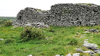
Cahercommaun, sometimes Cahercommane, is a triple stone ringfort on the south-east edge of the Burren area, in Kilnaboy, near the rural village of Carran, in County Clare, Ireland. It was built in the 9th century.

<span class="mw-page-title-main">Alyth</span> Human settlement in Scotland

Alyth is a town in Perth and Kinross, Scotland, five miles northeast of Blairgowrie and about 17 miles northwest of Dundee. In 2016 the town had an estimated population of 2,400.

<span class="mw-page-title-main">Dowth</span> Neolithic passage tomb located in the Boyne Valley, County Meath, Ireland

Dowth is a Neolithic passage tomb located in the Boyne Valley, County Meath, Ireland. It is one of the three principal tombs of the Brú na Bóinne World Heritage Site – a landscape of prehistoric monuments including the large passage-tombs of Dowth, Dowth Hall, Newgrange and Knowth. Unlike Newgrange and Knowth, Dowth has not been independently dated, but its features align it with the other passage tombs which date from between approximately 3200 and 2900 BC. However, Harbison (1970) dates the tomb at 2500 – 2000 BC. It is less developed as a tourist attraction than its neighbours, partly because the chamber is much lower, and partly because the decoration is less visible. It was partly excavated, in 1847 by the Royal Irish Academy who dynamited the roof causing the still visible crater, though it was pillaged by Vikings and earlier looters long before that.

<span class="mw-page-title-main">Hypogeum</span> Underground temple or tomb

A hypogeum or hypogaeum is an underground temple or tomb.

<span class="mw-page-title-main">Halliggye Fogou</span> Fogou in Cornwall, England

Headland Archaeology Ltd is a wholly owned subsidiary of the RSK Group. Headland provides archaeological services and heritage advice to the construction industry.

<span class="mw-page-title-main">Prehistoric Orkney</span> Overview of the prehistoric period on the Orkney Islands, Scotland

Prehistoric Orkney refers only to the prehistory of the Orkney archipelago of Scotland that begins with human occupation. Although some records referring to Orkney survive that were written during the Roman invasions of Scotland, “prehistory” in northern Scotland is defined as lasting until the start of Scotland's Early Historic Period.

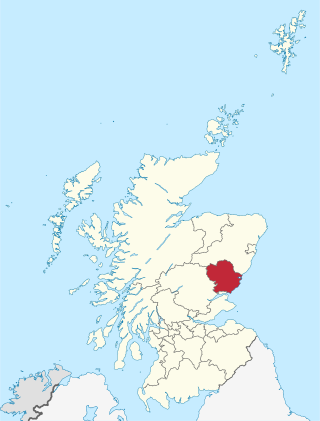
Carlungie and Ardestie Earthhouses can be found in farmland north of Monifieth and Carnoustie. They date to the late Iron Age, from the 1st to 2nd centuries AD. They are examples of souterrains, probably used to store food.

<span class="mw-page-title-main">Rennibister Earth House</span>

Rennibister Earth House is an Iron Age underground structure known as a souterrain. It is located on the Mainland of Orkney, in Scotland. The monument was discovered in 1926 when a threshing machine caused the roof to collapse. During excavation, the skeletal remains of six adults and twelve children were uncovered. Historic Environment Scotland established the site as a scheduled monument in 1928.

<span class="mw-page-title-main">Erdstall</span> A type of tunnel found across Europe

An erdstall is a type of tunnel found across Europe. They are of unknown origin but are believed to date from the Middle Ages. A variety of purposes have been theorized, including that they were used as escape routes or hiding places, but the most prominent theory is that they served a religious or spiritual purpose.

<span class="mw-page-title-main">Creevykeel Court Tomb</span> Megalithic tomb in County Sligo, Ireland

Creevykeel Court Tomb is one of the finest examples of a court tomb remaining in Ireland. The monument is located in the N15 Donegal to Sligo road, 50 meters north of Creevykeel cross-roads close to Cliffoney village in County Sligo. The original name for the Creevykeel monument is Caiseal an Bhaoisgin, the Fort of Bhaoisgin, Tobar an Bhaoisgin being the name of the well near the cairn. A second megalithic monument existed 300 meters to the north, but it was demolished around 1890.

<span class="mw-page-title-main">Donaghmore Souterrain</span>

Donaghmore Souterrain is a souterrain and National Monument located in County Louth, Ireland.

<span class="mw-page-title-main">Aghnaskeagh Cairns</span> Irish monument

Aghnaskeagh Cairns is a chambered cairn and portal tomb forming a National Monument in County Louth, Ireland.

References

  1. Crawford, O. G. S. (1959). Antiquity: A Quarterly Review of Archaeology. Antiquity Publications.
  2. Thomas, C. (1965). Rural Settlement in Roman Britain: Papers Given at a C.B.A. Conference Held at St. Hugh's College, Oxford, January 13, Council for British Archaeology, St. Hugh's College (University of Oxford), 1966, 130 pages
  3. Prehistoric Communities of the British Isles, 1971, Greenwood Press, 274 pages
  4. Thomas, C. (1972). Souterrains in the Sea Province. C.B.A. Research Report 9
  5. "The Cracknie Souterrain in Scotland's Borgie Forest., mapped as a 3D point cloud". Forestry and Land Scotland. 2022.
  6. Ginnever, Matthew (2017). "An Iron Age settlement and souterrain at Dubton Farm East, Brechin, Angus" (PDF). Tayside and Fife Archaeological Journal. 23: 1-12.
  7. Corcoran, W. (19671968). The souterrain at Rosal, Strathnaver, Sutherland. Proceedings of the Society of Antiquaries of Scotland , 100, 114118
  8. Hogan, C. M. (2007). Castle Bloody, In The Megalithic Portal, (Ed.) Burnham, A. 2007 Nov 6,
  9. Coleman, R. & Hunter, F. (2002). The excavation of a souterrain at Shanzie Farm, Alyth, Perthshire. Tayside and Fife Archaeological Journal, 8, 77101.
  10. Bailey, D. & Roycroft, N. (2003). Souterrain City. Archaeology Ireland, 66, 2427.
  11. Murphy, D. (1998). Archaeological excavation of a souterrain at Farrandreg, Dundalk, County Louth, County Louth Archaeological and Historical Journal, 24 (2), 261280.
  12. Lucas, A. T. (19711973). Souterrains: The Literary Evidence, Bealoideas3941, 165191.
  13. 1 2 Clinton, M. (2001). The Souterrains of Ireland, p. 33. Wordwell, Bray.
  14. Warner, R.B. (1979). The Irish souterrains and their background. In Subterranean Britain: aspects of underground archaeology, 100-144, (Ed) H. Crawford. London.
  15. O'Sullivan, M. & Downey, L. (2004). Souterrains. Archaeology Ireland, 70, 3436, (Winter 2004).