
Gráinne O'Malley, also known as Grace O'Malley, was the head of the Ó Máille dynasty in the west of Ireland, and the daughter of Eóghan Dubhdara Ó Máille.

Connemara is a region on the Atlantic coast of western County Galway, in the west of Ireland. The area has a strong association with traditional Irish culture and contains much of the Connacht Irish-speaking Gaeltacht, which is a key part of the identity of the region and is the largest Gaeltacht in the country. Historically, Connemara was part of the territory of Iar Connacht. Geographically, it has many mountains, peninsulas, coves, islands and small lakes. Connemara National Park is in the northwest. It is mostly rural and its largest settlement is Clifden.

Clew Bay is a large ocean bay on the Atlantic coast of County Mayo, Ireland. It is roughly rectangular and has more than a hundred small islands on its landward side; Ireland's best example of sunken drumlins. The larger Clare Island guards the entrance of the bay.

Aughagower or Aghagower is a small village in rural County Mayo in western Ireland. It is 6 km south-east of Westport. Aughagower has around forty houses, a pub and a shop, with a clear view of Croagh Patrick from Reek View. It is also at the centre of Aghagower civil parish which covers an area of 86.1 square miles. The village is known for its links to Saint Patrick and Tóchar Phádraig, the pilgrimage route from Ballintubber Abbey to Croagh Patrick.

Clare Island, also historically Inishcleer, is a mountainous island guarding the entrance to Clew Bay in County Mayo, Ireland. Historically part of the kingdom of Umhaill, it is famous as the home of the 16th century pirate queen Gráinne O'Malley. The population of the island is 138 according to the 2022 census. To the south-west lies Inishturk (inhabited) and Caher Island (uninhabited), and to the north is Achill Island.

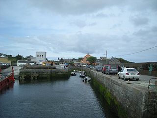
Louisburgh is a small town on the southwest corner of Clew Bay in County Mayo, Ireland. It is home to Sancta Maria College and the Gráinne O'Malley Interpretive Centre.

Inishbofin is a small island off the coast of Connemara, County Galway, Ireland. Inishbofin has around 180 inhabitants and is a tourist destination.

Inishturk is an inhabited island of County Mayo, in Ireland.
Cleggan is a fishing village in County Galway, Ireland. The village lies 10 km (7 mi) northwest of Clifden and is situated at the head of Cleggan Bay.
Caher is an Anglicised form of the Irish language word cathair and may refer to: Caher
During the Tudor conquest of Ireland (c.1540–1603), "surrender and regrant" was the legal mechanism by which Irish clans were to be converted from a power structure rooted in clan and kin loyalties, to a late-feudal system under the English legal system. The policy was an attempt to incorporate the clan chiefs into the English-controlled Kingdom of Ireland, and to guarantee their property under English common law, as distinct from the traditional Irish Brehon law system. This strategy was the primary non-violent method for Crown officials in the Dublin Castle administration to subjugate Irish clan leaders during the conquest. It was an unanticipated consequence to be required to pay fealty in currency instead of trade labor or commodities. The process of "surrender and regrant" thus created new, unfamiliar debt structures among the Irish, and these debts had social and political consequences.
Seán Mór Ó Dubhagáin was an Irish Gaelic poet.
Mathgamain mac Toirdhealbhach Mantach Ó Briain, Chief of the Name of the Clan Teige Ó Briain of Aran, died 1565.

Tibbot na Long Bourke, 1st Viscount Mayo was an Irish peer and parliamentarian. A prominent member of the MacWilliam Burkes of County Mayo, Tibbot was a Member of the Irish House of Commons and was later created the first Viscount Mayo. His successful life followed, and usefully illustrates, the difficult transition for Irish aristocrats from the traditional Gaelic world during the Tudor conquest of Ireland.

Umhaill or Umhall was a Gaelic territory around Clew Bay in the west of what is now County Mayo, Ireland, comprising the baronies of Burrishoole and Murrisk. By the 12th century, its ruling dynasty were known as the Uí Máille (O'Malleys). Originally an autonomous part of the kingdom of Connacht, it later became one of the vassal territories of the Mac William Íochtar. Umhaill's last and most famous ruler was Grace O'Malley, nicknamed "the pirate queen". In 1576, during the Tudor conquest of Ireland, she agreed to the surrender and regrant policy, accepting English inheritance law in return for official title deeds to her lands. On her death the lands were inherited by her son Tibbot "na Long". Umhaill had a strong seafaring culture. Important sites associated with it include Carrickkildavnet Castle, Carrickahowley Castle, Granuaile's Castle and Clare Island Abbey.

Renvyle or Rinvyle is a peninsula and electoral division in northwest Connemara in County Galway, close to the border with County Mayo in Ireland.

Clare Island Abbey, officially St. Brigid's Abbey, is a former Cistercian monastery and National Monument located in Clare Island, County Mayo, Ireland.

Castlekirk, also called Hen's Castle, is a tower house and National Monument located in Lough Corrib, Ireland.
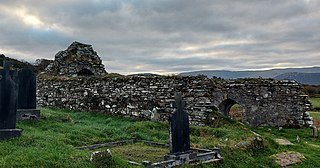
Kilgeever Abbey or church is situated just outside Louisburgh in the parish of Kilgeever, in the barony of Murrisk, County Mayo. The site consists of a ruined church, a graveyard and a holy well, where pilgrimages or patterns take place. The site is part of the Clew Bay Archaeological Trail. The church is a multi-period church containing a late medieval doorway. The graveyard on the site is suggested to be from Early Christian times and continues to be in use. Within the graveyard, there is a pillar stone incised with a cross, the graveyard also contained a free-standing stone and a portable stone cross with incised crosses which are now in private ownership.


