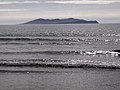
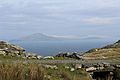
Inishturk

Last updated

Inishturk
Native name:
Inis Toirc
Inishturk north.jpg
North coast of Inishturk
Island of Ireland location map.svg
Red pog.svg
Inishturk
Geography
Location Atlantic Ocean
Coordinates 53°42′05″N10°06′30″W / 53.7014°N 10.1083°W / 53.7014; -10.1083
Area6 km2 (2.3 sq mi) [1]
Highest elevation189.3 m (621.1 ft) [2]
Administration
Province Connacht
County Mayo
Demographics
Population56 (2022) [3]
Pop. density8.5/km2 (22/sq mi)
Ethnic groups Irish

Inishturk (Inis Toirc in Irish, meaning Wild Boar Island) is an inhabited island of County Mayo, in Ireland. [4]

Contents

Geography

Islands off County Mayo MayoIslands.PNG
Islands off County Mayo

The island lies about 15 km (9 mi) off the coast; its highest point reaches 189.3 m (621.1 ft) above sea level. [2] Between Inisturk and Clare Island lies Caher Island. It has a permanent population of 58 people. [5] There are two main settlements, both on the more sheltered eastern end of the island, Ballyheer and Garranty. Bellavaun and Craggy are abandoned settlements.

History

Inishturk has been inhabited on and off since 4,000 BCE and has been inhabited permanently since at least 1700. [6] Some of the island's more recent inhabitants are descended from evacuees from Inishark to the southwest.[ citation needed ]

A Martello tower was built during the Napoleonic Wars, c.1805, on Inishturk's western coast. [7]

Recent history

In 1993, Inishturk Community centre was opened, this community centre doubles as a library and a pub. In June 2014 the ESB commissioned three new Broadcrown BCP 110-50 100kVA diesel generators to supply electricity to the island. [8] The ESB have operated a diesel power station on the island since the 1980s [9]

Inishturk gained international attention in 2016 after a number of websites claimed that the island would welcome any American "refugees" fleeing a potential Donald Trump presidency. [10] [11] [12] These were examples of the type of "fake news" that arose during the 2016 US presidential election campaign. [13]

The island is home to a primary school on the island which in 2011 had only 3 pupils; this is believed to be the smallest primary school in Ireland. [14]

Demographics

The table below reports data on Inisturk's population taken from Discover the Islands of Ireland (Alex Ritsema, Collins Press, 1999) and the Census of Ireland.

Historical population
YearPop.±%
1841577    
1851174−69.8%
1861110−36.8%
1871112+1.8%
1881116+3.6%
1891135+16.4%
1901135+0.0%
1911132−2.2%
1926101−23.5%
YearPop.±%
1936107+5.9%
1946125+16.8%
1951123−1.6%
1956110−10.6%
1961108−1.8%
196692−14.8%
197183−9.8%
197985+2.4%
198176−10.6%
YearPop.±%
198690+18.4%
199178−13.3%
199683+6.4%
200272−13.3%
200658−19.4%
201153−8.6%
201651−3.8%
202256+9.8%
Source: Central Statistics Office. "CNA17: Population by Off Shore Island, Sex and Year". CSO.ie. Retrieved 12 October 2016.

Transport

Prior to 1997 there was no scheduled ferry service and people traveled to and from the islands using local fishing boats. Since then a ferry service operates from Roonagh Quay, Louisburgh, County Mayo. [15] The pier was constructed during the 1980s by the Irish government, around this time the roads on the island were paved. [16]

See also

Related Research Articles

<span class="mw-page-title-main">Clare Island</span> Island in County Mayo, Ireland

Clare Island, also historically Inishcleer, is a mountainous island guarding the entrance to Clew Bay in County Mayo, Ireland. Historically part of the kingdom of Umhaill, it is famous as the home of the 16th century pirate queen Gráinne O'Malley. The population of the island is 138 according to the 2022 census. To the south-west lies Inishturk (inhabited) and Caher Island (uninhabited), and to the north is Achill Island.

<span class="mw-page-title-main">Louisburgh, County Mayo</span> Town in Connacht, Ireland

Louisburgh is a small town on the southwest corner of Clew Bay in County Mayo, Ireland. It is home to Sancta Maria College and the Gráinne O'Malley Interpretive Centre.

<span class="mw-page-title-main">Tory Island</span> Island in Ulster, Ireland

Tory Island, or simply Tory, is an island 14.5 kilometres off the north-west coast of County Donegal, Ireland, and is the most remote inhabited island of Ireland. The name means "place of steep rocky heights".

Collanmore Island is an island in Clew Bay, County Mayo, Ireland.

<span class="mw-page-title-main">Inishbofin, County Galway</span> Island in County Galway, Ireland

Inishbofin is a small island off the coast of Connemara, County Galway, Ireland. Inishbofin has around 180 inhabitants and is a tourist destination.

<span class="mw-page-title-main">Caher Island</span>

Caher Island, an uninhabited island off the coast of County Mayo in Ireland, is situated between the larger Clare Island and Inishturk.

<span class="mw-page-title-main">Cleggan</span> Village in County Galway, Ireland

Cleggan is a fishing village in County Galway, Ireland. The village lies 10 km (7 mi) northwest of Clifden and is situated at the head of Cleggan Bay.

Caher is an Anglicised form of the Irish language word cathair and may refer to: Caher

<span class="mw-page-title-main">Inishark</span> Island in County Galway, Ireland

Inishark or Inishshark, sometimes called Shark Island, is a small island neighbouring the larger Inishbofin in County Galway, Ireland.

<span class="mw-page-title-main">Inishbofin, County Donegal</span> Island in County Donegal, Ireland

Inishbofin, also Inishbofinne, is an island and townland off the coast of Machaire Uí Rabhartaigh (Magheraroarty), County Donegal, Ireland.

<span class="mw-page-title-main">Inishkea Islands</span> Islands of the Mayo coast in Ireland

The Inishkea Islands are situated off the coast of the Belmullet peninsula in County Mayo in Ireland. They are believed to be named after a saint that lived there, called Saint Kea. There are two main islands – Inishkea North and Inishkea South.

<span class="mw-page-title-main">Ardoileán</span> Island in Galway, Ireland

Ardoileán or Ard Oileán, known in English as High Island, is a small island off the northwest coast of Connemara in County Galway, Ireland. It was once the site of an early Irish monastic community.

Heir Island, also known as Hare Island or Inishodriscol, is an island in southwest County Cork, Ireland. It has a year-round population of around 25–30. The island is 2.5 km long and 1.5 km wide. It is the fourth-largest of Carbery's Hundred Isles, after Sherkin Island, Clear Island and Long Island. It is near Cunnamore Pier, which is its main access point.

<span class="mw-page-title-main">Inish Turk Beg</span>

Inish Turk Beg is a private island in Clew Bay, County Mayo on the west coast of Ireland. Between 2003 and 2013, it was owned by Nadim Sadek, an Irish-Egyptian marketing entrepreneur. The island is approximately 10 km (6.2 mi) by road from the towns of Newport and Westport, County Mayo, and 67 km (42 mi) from Ireland West Airport Knock.

<span class="mw-page-title-main">Wild Atlantic Way</span> Irish coastal 2,500 km road route

The Wild Atlantic Way is a tourism trail on the west coast, and on parts of the north and south coasts, of Ireland. The 2,500 km driving route passes through nine counties and three provinces, stretching from County Donegal's Inishowen Peninsula in Ulster to Kinsale, County Cork, in Munster, on the Celtic Sea coast.

<span class="mw-page-title-main">Cleggan Bay</span>

Cleggan Bay is a natural ocean bay in County Galway, Republic of Ireland.

<span class="mw-page-title-main">Renvyle</span> Gaelic sports club in County Galway, Ireland

Renvyle or Rinvyle is a peninsula and electoral division in North-West Connemara in County Galway, close to the border with County Mayo in Ireland.

<span class="mw-page-title-main">Inishturk South</span>

Inishturk is a small island and a townland of County Galway, in Ireland. The island is also referred as Inishturk South in order to tell it apart from the Inishturk island located in County Mayo.

Turbot is a small island and a townland of County Galway, in Ireland, also referred as Inishturbot and Talbot Island.

References

  1. R. Lloyd Praeger (March 1907). "The Flora of Inishturk". The Irish Naturalist. 16 (3): 113–125. JSTOR   25523043. Inishturk lies off the Mayo coast [..] It is also much smaller than either [of its neighbours], having an area of 214 square miles, as against Bofin's 412 square miles (Inishark included), and Clare's 616 square miles
  2. 1 2 "Inisturk". MountainViews. Ordnance Survey Ireland . Retrieved 23 February 2015.
  3. Population of Inhabited Islands Off the Coast (Report). Central Statistics Office. 2023. Retrieved 29 June 2023.
  4. Sometimes the island's name is reported as Inisturk, as for instance by Google Maps
  5. "No Christmas medical cover on island of Inishturk". breakingnews.ie. 24 December 2014.
  6. "Mayo Walks - Inishturk". Archived from the original on 17 December 2019. Retrieved 12 October 2016.
  7. "Ten Reasons to Take a Trip to Inishturk". destinationwestport.com. Retrieved 3 November 2023.
  8. BC Inishturk case study
  9. New hope for Inishturk Archived 12 October 2016 at the Wayback Machine , esbelectricmail.com. Accessed 29 September 2022.
  10. "Inishturk: The Tiny Irish Island That Will Welcome American Refugees" . Retrieved 29 September 2022.
  11. Huffington Post - Looking to escape Donald Trump, Huffingtonpost.com. Accessed 29 September 2022.
  12. Remote Irish island seeks American fleeing Donald Trump presidency, Irishcentral.com. Accessed 29 September 2022.
  13. "Fake news is big business - and may have handed Trump the election" . The Business Post. 20 November 2016.
  14. Three-pupil school urges families to consider move to 'idyllic' island, irishtimes.com. Accessed 29 September 2022.
  15. islander committed to her community
  16. Winter Inishturk