Corofin, County Clare

Last updated

Corofin
Cora Finne
town
Corofin rue principale.jpg
Main street, Corofin
Ireland adm location map.svg
Red pog.svg
Corofin
Location in Ireland
Coordinates: 52°56′43″N9°03′43″W / 52.945225°N 9.062004°W / 52.945225; -9.062004
Country Ireland
Province Munster
County County Clare
Elevation
30 m (100 ft)
Population
 (2016) [1]
776
Time zone UTC+0 (WET)
  Summer (DST) UTC-1 (IST (WEST))
Irish Grid Reference R285887

Corofin (Irish : Cora Finne [2] or Coradh Finne) is a town on the River Fergus in northern County Clare, Ireland and also a parish of the same name in the Catholic Diocese of Killaloe.

Contents

The 2016 population was 776, up from 689 in 2011. [1] [3]

Name

The name Corofin means "the white or foam-flecked ford" from the Irish : Finn Coradh, the earliest form of the name to be found in the literature: "fearann re hucht Finn Coradh". - [Ó hUidhrín, 15c. Topographical Poem][ citation needed ] A different translation is "Finne's weir". [4] :15

The town name is sometimes spelled "Corrofin". [2] Corofin also styles itself as "The Gateway to the Burren" or "The Angler's Paradise". [5]

Geography

The town is 12 km (7.5 mi) north of the county town of Ennis, at the crossroads of the R460 and R476 regional roads. It is on the southern edge of the upland limestone region of The Burren. Corofin is in the civil parish of Kilnaboy in the Barony of Inchiquin. [6] It lies across the townlands of Baunkyle, Laghtagoona and Kilvoydan.

It lies in the parish of the same name of the Roman Catholic Diocese of Killaloe.

Places of interest

Inchiquin Inn in 1989 Corofin, Co Clare. Inchiquin Inn, Kenny's Drinking Emporium stained glass, Apr 1989.jpg
Inchiquin Inn in 1989

On Church Street is the former Church of Ireland, St. Catherine's Church, built between 1715 and 1720 by Catherine Kneightly. It was renovated c. 1820 and by 1829 the steeple had been added. [7] The building is now in use by the Clare Heritage and Genealogical Research Centre. [8] An Irish National Monument, the Cross Inneenboy, also known as Roughan Hill Tau Cross, is a stone tau cross which has been moved into the centre for safe keeping.

Inchiquin Castle. View of the outside, main building on the left, overgrown tower to the right. Inchiquin Castle exterior.jpg
Inchiquin Castle. View of the outside, main building on the left, overgrown tower to the right.

Inchiquin Castle is located just outside the town, on the north side of Lake Inchiquin. It was possibly begun by Teige-an-Chomhaid O'Brien (d. 1466). In 1542, it belonged to Turlough, son of Murrough, first Baron of Inchiquin. Murrough O'Brien, the fourth Baron, was in possession in 1580. His descendants, the Marquesses of Thomond, derived their title of Earl of Inchiquin from this estate. During the Nine Years' War, Hugh Roe O'Donnell raided Clare and Inchiquin Castle was attacked by one of his lieutenants, Maguire of Fermanagh. During the Confederate Wars Christopher O'Brien, Murrough the Burner's brother, lived here. Murrough's son, Colonel John O'Brien, abandoned Inchiquin towards the end of the 17th century. By then it had deteriorated into a ruin. Today the castle remains a ruin surrounded by pastures. Part of the older castle tower is still extant as is a good portion of the later 17th-century banquet hall. [7]

Town twinning

Corofin is twinned with Tonquédec in France.[ citation needed ]

Notable people

See also

Related Research Articles

<span class="mw-page-title-main">County Clare</span> County in Ireland

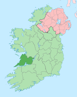
County Clare is a county in the province of Munster in the Southern part of the republic of Ireland, bordered on the west by the Atlantic Ocean. Clare County Council is the local authority. The county had a population of 127,938 at the 2022 census. The county seat and largest settlement is Ennis.

<span class="mw-page-title-main">Inagh</span> Village in County Clare, Ireland

Inagh is a village and civil parish in County Clare, Ireland. It is situated 14 km west of Ennis on the Inagh River. It contains the villages of Inagh and Cloonanaha.

<span class="mw-page-title-main">Baron Inchiquin</span> Title in the Peerage of Ireland

Baron Inchiquin is one of the older titles in the Peerage of Ireland. It was one of two titles created on 1 July 1543 for Murrough O'Brien, Prince of Thomond, who was descended from the great high king Brian Boru. The grant of the English titles was conditional upon the abandonment of any Irish titles, the adoption of English customs and laws, pledging of allegiance to the Crown, apostasy from the Catholic Church, and conversion to the Church of England. Murrough was made both Earl of Thomond in the Peerage of Ireland, with remainder to his nephew Donough O'Brien and Baron Inchiquin, with remainder to his male heirs. Following the death of his cousin, Conor Myles John O' Brien in June 2023, Conor John Anthony O' Brien is currently the 19th Baron Inchiquin

<span class="mw-page-title-main">Kilfenora</span> Village in County Clare, Ireland

Kilfenora is a village and a civil parish in County Clare, Ireland. It is situated south of the karst limestone region known as the Burren. Since medieval times when it was the episcopal see of the Bishop of Kilfenora, it has been known as the "City of the Crosses" for its seven high crosses. The village had around 220 inhabitants in 2011. Much of the TV show Father Ted (1995–98) was filmed there.

<span class="mw-page-title-main">McInerney</span> Surname list

The name McInerney is of noble Irish origin where it is found in the modern Irish form of Mac an Airchinnigh and in the old and literary forms of Mac an Oirchinnigh and Mac an Oirchindig. The pronunciation of Mac an Oirchinnigh led the name to be sometimes anglicised as McEnherheny in Irish documents from the 16th–19th centuries. The name translates to "son of the erenagh" in Irish, literally meaning "son of the Lord of church lands". Airchinneach may in turn derive from the twin components of air ("noble") and ceann ("head"), therefore meaning a 'noble-head' or 'Lord', denoting its aristocratic status in medieval Ireland. The coat of arms is three red lions passant, and the motto is Veritas, meaning "Truth". In some places, the motto can be found as Vincit Veritas, meaning "Truth Conquers", or "Truth Prevails".

<span class="mw-page-title-main">Leamaneh Castle</span> Castle in County Clare, Ireland

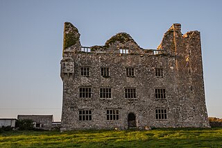
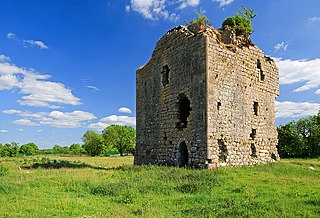
Leamaneh Castle is a ruined castle located in the townland of Leamaneh North, parish of Kilnaboy, between the villages of Corofin and Kilfenora at the border of the region known as the Burren in County Clare, Ireland. It consists of a 15th-century tower house and a 17th-century mansion.

<span class="mw-page-title-main">Dysert O'Dea Monastery</span> 12th-century Irish church

Dysert O'Dea Church near Corofin in County Clare, Ireland stands on the site of an early Christian monastery which was reportedly founded by St. Tola in the 8th century. Most of the present structures are from the 12th century.

<span class="mw-page-title-main">Carrigaholt</span> Fishing village in County Clare, Ireland

Carrigaholt is a small fishing village in County Clare, Ireland, a castle and a Catholic parish by the same name. The area was officially classified as part of the West Clare Gaeltacht; an Irish-speaking community; until 1956.

<span class="mw-page-title-main">Corcomroe Abbey</span> Ruined Cistercian friary in Clare, Ireland

Corcomroe Abbey is an early 13th-century Cistercian monastery located in the north of the Burren region of County Clare, Ireland, a few miles east of the village of Ballyvaughan in the Barony of Burren. It was once known as "St. Mary of the Fertile Rock", a reference to the Burren's fertile soil.

<span class="mw-page-title-main">Corofin, County Galway</span> Village in County Galway, Ireland

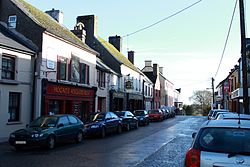
Corofin or Corrofin is a village and parish in County Galway, Ireland, situated on the N17 road between Galway City and Tuam.

<span class="mw-page-title-main">Tubber, County Clare</span> Village in County Clare, Ireland

Tubber is a village in the north of County Clare, Ireland.

<span class="mw-page-title-main">Kilnaboy</span> Village in County Clare, Ireland

Kilnaboy or Killinaboy is a village, townland and civil parish in County Clare, Ireland. It is located in the Burren, and as of the 2011 census the area had 347 inhabitants.

<span class="mw-page-title-main">Dysert, County Clare</span> Civil parish in County Clare, Ireland

Dysert is a civil parish in County Clare, Ireland. The parish was formerly called Dysert O’Dea, from its having been the territory of the sept of that name. It is part of the ecclesiastical parish of Dysart and Ruan. The ruins of O'Dea Castle and a 12th-century church of Dysert O'Dea Monastery are in the townland of the same name.

<span class="mw-page-title-main">Dromore, County Clare</span>

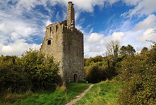
Dromore, County Clare is a rural townland in County Clare in the Republic of Ireland. It is located in the parish of Ruan and was formerly the location of Dromore House. Today, most of the townland is accounted for by Dromore Wood Nature Reserve. It is open to the public and also contains the ruins of Dromore Castle.

Inchiquin is a barony in County Clare, Ireland. This geographical unit of land is one of 11 baronies in the county. Its chief town is Corofin. It is administered by Clare County Council.

<span class="mw-page-title-main">Rath, County Clare</span> Civil parish in Clare, Ireland

Rath is a civil parish in the barony of Inchiquin in County Clare, Ireland.

<span class="mw-page-title-main">Kilchreest</span> Civil parish in Munster, Ireland

Kilchreest is a civil parish of County Clare, Ireland. It contains the village of Ballynacally and is part of the Roman Catholic parish of Ballynacally (Clondegad), which includes the civil parish of Clondagad to the north.

<span class="mw-page-title-main">Dysart and Ruan</span> Catholic parish in County Clare, Ireland

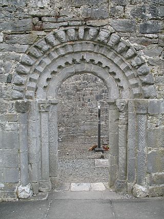
Dysart and Ruan is a Catholic parish in County Clare, Ireland. It covers the civil parishes of Ruan and Dysert, and includes the village of Ruan, which holds the parish office. The parish contains the ruins of the 12th century St. Tola's Church, part of Dysert O'Dea Monastery.

<span class="mw-page-title-main">Dromore Castle (County Clare)</span> Tower house in County Clare, Ireland

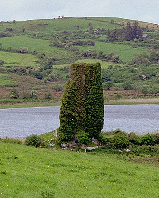
Dromore Castle is a tower house and National Monument located between the towns of Crusheen and Corofin in County Clare, Ireland.

<span class="mw-page-title-main">Inneenboy cross</span> Stone tau cross in County Clare, Ireland

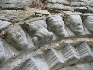
The Inneenboy cross or the Roughan Hill Tau Cross is a stone tau cross located in County Clare, Ireland. It is a National Monument.

References

  1. 1 2 "Census 2016 Sapmap Area: Settlements Corrofin". Central Statistics Office (Ireland) . Retrieved 21 February 2018.
  2. 1 2 Corrofin, County Clare Placenames Database of Ireland. Retrieved: 2011-11-22.
  3. "Census 2011 - Table 5 Population of towns ordered by county and size, 2006 and 2011" (PDF). CSO. Archived from the original (PDF) on 4 March 2016. Retrieved 7 January 2014.
  4. 1 2 Roche, D. The Clare Guide - Official Irish Tourist Board Guide. Bord Failte.
  5. "Corofin, Corrofin or Curofin". Parliamentary Gazetteer of Ireland. 1845. Retrieved 2 April 2014.
  6. 1 2 "Corofin, Places of Interest". Clare County Library. Retrieved 2 January 2017.
Sources