
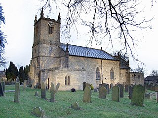
Thornbury is a market town and civil parish in the South Gloucestershire unitary authority area of England, about 12 miles (19 km) north of Bristol. It had a population of 12,063 at the 2011 census, rising to 14,496 in the 2021 census. Thornbury is a Britain in Bloom award-winning town, with its own competition: Thornbury in Bloom. The earliest documentary evidence of a village at "Thornbyrig" dates from the end of the 9th century. The Domesday Book of 1086 noted a manor of "Turneberie" belonging to William the Conqueror’s consort, Matilda of Flanders, with 104 residents.
Dore is a large village in the Sheffield district, in the county of South Yorkshire, England. The village lies on a hill above the River Sheaf which gave Sheffield its name and, until 1934, was part of Derbyshire but it is now a suburb of the city.

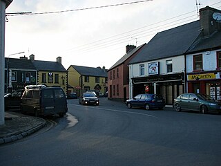
Ennis is the county town of County Clare, in the mid-west of Ireland. The town lies on the River Fergus, north of where the river widens and enters the Shannon Estuary. Ennis is the largest town in County Clare, with a population of 27,923, making it the 6th largest town, and 11th largest urban settlement, as of the 2022 census. Dating from the 12th century the town's Irish name is short for Irish: Inis Cluana Rámhfhada, meaning 'Island of the long rowing meadow', deriving from its location between two courses of the River Fergus.

Portadown is a town in County Armagh, Northern Ireland. The town sits on the River Bann in the north of the county, about 24 miles (39 km) southwest of Belfast. It is in the Armagh City, Banbridge and Craigavon Borough Council area and had a population of about 32,000 at the 2021 Census. For some purposes, Portadown is treated as part of the "Craigavon Urban Area", alongside Craigavon and Lurgan.

Potters Bar is a town in Hertfordshire, England, 13 miles (21 km) north of central London. In 2011, it had a population of 21,882. In the 2021 census, the four wards that make up Potters Bar - Bentley Heath & The Royds, Furzefield, Oakmere and Parkfield - had a combined population of 22,536; this includes several smaller outlying hamlets contained in the Bentley Heath & The Royds ward, such as Bentley Heath and Ganwick Corner. In 2022, the population was around 23,325.

Alsager is a town and civil parish in the unitary authority of Cheshire East in Cheshire, England. It is located to the north-west of Stoke-on-Trent and east of Crewe. The town's population was 13,389 at the 2021 census.

Caherdavin is a northern suburban district of Limerick city in the mid-west of Ireland. As of 2022, the population of Caherdavin is 7,364.

Ballyfermot is a suburb of Dublin, Ireland. It is located seven kilometres west of the city centre, south of Phoenix Park. It is bordered by Chapelizod on the north, by Bluebell on the south, by Inchicore on the east, and by Palmerstown and Clondalkin on the west. The River Liffey lies to the north, and the Grand Canal, now a recreational waterway, lies to the south of Ballyfermot. Ballyfermont lies within the postal district Dublin 10. Cherry Orchard, which is also a suburb, is sometimes considered to be within Ballyfermot.

Lifford is the county town of County Donegal, Ireland, the administrative centre of the county and the seat of Donegal County Council, although the town of Letterkenny is often mistaken as holding this role.

Donabate is an outer suburb of Dublin, Ireland, about 21 kilometres north-northeast of Dublin, within the local government area of Fingal. The town is on a peninsula on Ireland's east coast, between the Rogerstown Estuary to the north and Broadmeadow Estuary to the south. Donabate is a civil parish in the ancient barony of Nethercross.

Knocklyon is a suburb of the city of Dublin, located in South Dublin, Ireland. Unlike many Dublin suburbs, Knocklyon was not developed around a village; rather it largely consists of modern housing, with a number of old cottages and farmhouses along Knocklyon Road attesting to the area's rural past.

Clondalkin is a southwestern outer suburb of Dublin, Ireland, 10 km (6 mi) west of Dublin city centre, Ireland, under the administrative jurisdiction of South Dublin. It features an 8th-century round tower that acts as a focal point for the area.
Newmarket-on-Fergus, historically known as Corracatlin, is a town in County Clare, Ireland. It is 13 kilometres from Ennis, 8 kilometres from Shannon Airport, and 24 kilometres from Limerick.
Castleknock is an affluent suburb located 8 km (5 mi) west of the centre of Dublin city, Ireland. It is centred on the village of the same name in Fingal.
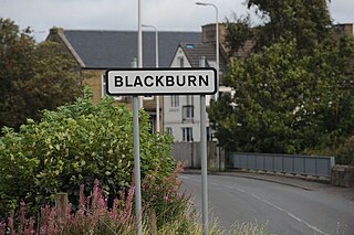
Blackburn is a town in West Lothian, Scotland, near both Bathgate and Livingston, two of the larger towns in the county. It is situated approximately 20 miles (32 km) west of Edinburgh and 25 miles (40 km) east of Glasgow on the old A8 road.
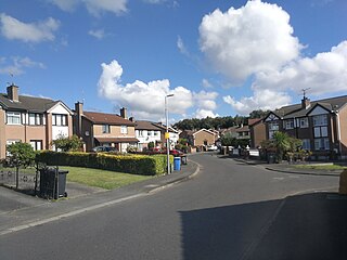
Poleglass is an area of west Belfast in Northern Ireland. It is the name of a townland, a modern electoral ward, and a working class suburb. The townland is situated in the civil parish of Derriaghy and the historic Barony of Belfast Upper. It is mainly an Irish nationalist area.
Roslevan is a residential area on the eastern side of Ennis, County Clare, Ireland. The area has many housing estates such as Oakleigh Wood, Cappahard, Corrovorin. There are two council housing estates in the area, called, Bridgecourt and Bridgeview. It is expected that by 2012 the area will have a population of 7,000.
Huntstown and Littlepace is a set of modern housing developments that forms a remote suburb of Dublin city in the county of Fingal in Ireland. It was built in the townlands of Littlepace (westerly) and Huntstown (easterly) which are the southernmost townlands of the civil parish of Mulhuddart. The district is also a parish in the Blanchardstown deanery of the Roman Catholic Archdiocese of Dublin. The nearest villages in the county are Ongar, Mulhuddart and Clonsilla along with Clonee in County Meath.

Brickens, officially Brickeens, is a village and townland on the N60 road between Ballyhaunis and Claremorris in southeast County Mayo in Ireland. The River Robe flows through the village which is 65 metres above sea level, and old ordnance survey maps show the townland with an area of 368 acres and 23 perches – equivalent to nearly 150 hectares.
Ennis is a parish in County Clare, Ireland, and part of the Abbey grouping of parishes within the Roman Catholic Diocese of Killaloe.

