A townland is a small geographical division of land, historically and currently used in Ireland and in the Western Isles in Scotland, typically covering 100–500 acres (40–202 ha). The townland system is of Gaelic origin, antedating the Norman invasion, and most have names of Irish origin. However, some townland names and boundaries come from Norman manors, plantation divisions, or later creations of the Ordnance Survey. The total number of inhabited townlands in Ireland was 60,679 in 1911. The total number recognised by the Irish Place Names database as of 2014 was 61,098, including uninhabited townlands, mainly small islands.

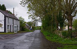
Doora is a village and civil parish in County Clare, Ireland, just to the east of the town of Ennis.

Spancil Hill, or in original spelling Spancilhill, is a traditional Irish folk ballad composed by Michael Considine (1850–73), who was born in Spancil Hill and migrated to the US. It bemoans the plight of the Irish emigrants who so longed for home from their new lives in America. This song is sung by a man who longs for his home in Spancill Hill, County Clare, his friends and the love he left there. All the characters and places in this song are real.
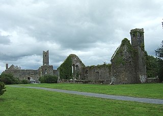
Quin is a village in southeast County Clare, Ireland. The name also refers to a civil parish in the barony of Bunratty Upper, and to an ecclesiastical parish of the same name. The main attraction in the vicinity is Quin Abbey, the ruins of Franciscan friary, which is open to the public. Although roofless, much of the structure remains and is relatively well-preserved. The abbey was built on the foundations of an earlier Norman castle; the foundations of three corner towers can still be seen.

Feenagh, or Finogh, Phinagh is a civil parish in County Clare, Ireland.
Clonloghan is a civil parish of County Clare, Ireland, located 21.7 kilometres (13.5 mi) by road northwest of Limerick, just north of Shannon.
Clooney is a civil parish of County Clare, Ireland, located to the northeast of Ennis, south of Inchicronan. The area is marshy, with the Oysterman's Marsh Natural Heritage Area in the vicinity. Clooney-Quin GAA is a GAA club for the Catholic parish of Clooney and Quin.
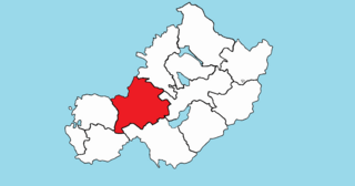
Drumline is a civil parish of County Clare, Ireland, located about 20 kilometres (12 mi) northwest of Limerick, just north of Shannon.
Kilraghtis is a civil parish of County Clare, Ireland. It covers an area northeast of the town of Ennis, and includes the Ennis suburb of Roslevan.
Crusheen, formerly called Inchicronan, is a civil parish in County Clare, Ireland. There is also a catholic parish Crusheen, covering the same area. The parish lies to the northeast of Ennis. It contains the villages of Crusheen and Ballinruan.
St. Munchin's Parish is a civil parish that lies partly in County Clare and partly in County Limerick in Ireland, including the centre of the city of Limerick. It takes its name from Saint Munchin, the first Bishop of Limerick. According to tradition its church was the first cathedral of the diocese of Limerick, built in 561 AD.
Killeely is a civil parish that lies partly in County Clare and partly in County Limerick in Ireland.
Kilfintinan is a civil parish in County Clare, Ireland. It is part of the Catholic parish of Cratloe.
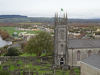
St. Patrick's, or Kilquane, is a civil parish that is situated on both banks of the River Shannon near the city of Limerick in Ireland. It is unusual in that it is distributed over three baronies: Bunratty Lower, Clanwilliam and the barony of the City of Limerick. Besides the suburbs of the city, it also contains the villages of Ardnacrusha and Parteen. It is known for the Ardnacrusha power plant, a major hydroelectric plant.

Kilmaleery is a civil parish in County Clare, Ireland. It is part of the Catholic parish of Newmarket-on-Fergus.
Carntemple, once known as Kilbrecan, is a ruined church in the civil parish of Doora, County Clare, Ireland. It may date back to 480 AD. Little remains except the massive foundations.
Rathconrath, previously the barony of Rathcomyrta, before that Daltons country, is a barony in the west of County Westmeath, in Ireland. It was formed by 1542. It is bordered by County Longford to the north–west and five other Westmeath baronies: Moygoish to the north, Moyashel and Magheradernon to the east, Moycashel and Clonlonan to the south and Kilkenny West to the west. Note that the village of Rathconrath is not synonymous with the barony of the same name.

Kells is a barony in the south-west of County Kilkenny, Ireland. It is one of 12 baronies in County Kilkenny. The size of the barony is 155.6 square kilometres (60.1 sq mi). There are 10 civil parishes in Kells, made up of 167 townlands. The chief town is Kells.

The barony of Knocktopher is a barony in the west of County Kilkenny, Ireland. The barony is 46,765 acres (189.25 km2) in size. There are 16 civil parishes made up of 125 townlands. It is one of 12 baronies in the county. The chief town is Mullinavat and it contains the settlements of Stonyford, Ballyhale, Hugginstown, Knocktopher, and Dunnamaggan. The M9 motorway bisects the barony.