Carrigaholt

Last updated

Carrigaholt
Carraig an Chabhaltaigh
Village
Carrigaholt castle.jpg
Carrigaholt Castle as seen from the main town area
Ireland adm location map.svg
Red pog.svg
Carrigaholt
Location in Ireland
Coordinates: 52°36′N9°42′W / 52.6°N 9.7°W / 52.6; -9.7
Country Ireland
Province Munster
County County Clare
Time zone UTC+0 (WET)
  Summer (DST) UTC-1 (IST (WEST))
Irish Grid Reference Q841518
Website www.kilrush.ie

Carrigaholt (Irish : Carraig an Chabhaltaigh, meaning 'rock of the fleet') [1] is a small fishing village in County Clare, Ireland, a castle and a Catholic parish by the same name. The area was officially classified as part of the West Clare Gaeltacht; an Irish-speaking community; until 1956.

Contents

Location

Carrigaholt lies at the mouth of the Moyarta river, which flows into the estuary of the River Shannon about 15 km from the tip of the Loop Head peninsula and about 10 km from the resort town of Kilkee on the north coast of the peninsula. The village boasts a ruined castle that stood guard over the mouth of the Shannon and the local fishing pier.

Economy

Fishing is still continued in the village with a small number of boats delivering their catches to a local processing company. The village is also the local centre for the local farming community. The village has benefited recently from tourism, mainly provided by residents from Limerick some 110 km to the east. The village has two restaurants, a fast food take-away and four public houses, some of which offer live entertainment, particularly during the summer high season. There is a holiday caravan park located nearby.

A local business (Carrigaholt Dolphin Watch) offers boating trips to observe dolphins in the mouth of the Shannon River, home to one of the largest pods in Europe. The Carrigaholt Sea Angling Centre offers fishing packages for up to 8 fisherman at a time and runs a purpose-built boat. Catches include ray, conger, bass, dogfish, tope, cod, pollock, hake and turbot. Other features include a beach suitable for swimming and watersports, two piers, and local village shops for food necessities.

Facilities

Carrigaholt parish, which also covers Doonaha, is part of the Roman Catholic Diocese of Killaloe. [2] The Church of the Blessed Virgin Mary, Carrigaholt, was built in 1832–1833. There is a school in Carrigaholt. Coláiste Eoghain Uí Chomhraídhe, the Irish college one mile west of Carrigaholt was founded in 1912. Students come from various locations in Ireland to learn and improve their Irish each Summer.

Carrigaholt Castle
viewed from within the grounds. Carrigaholt castle 2.jpg
Carrigaholt Castle
viewed from within the grounds.

Carrigaholt Castle

Carrigaholt Castle was built in about 1480 by the McMahons, chiefs of the Corcabascin Peninsula. It stands at the end of a fishing pier overlooking the Shannon Estuary and the harbour. This is a tall, well-preserved five storey tower house surrounded by a bawn (walled courtyard). The castle features murder holes and a bartizan. A spiral staircase leads to the top of the building where there was a stone vaulted roof.

The castle was occupied by Teige Caech "the short sighted" McMahon in September 1588 when seven ships of the Spanish Armada anchored at Carrigaholt. Although aid was refused by the McMahons (who are descendants of Mathgamain mac Cennétig), the castle was nonetheless unsuccessfully besieged shortly afterwards by Sir Conyers Clifford (Governor of Connaught). The following year the renegade fourth Earl of Thomond (Donagh O'Brien) captured it after a four-day siege and, in breach of the surrender terms, hanged all the defenders.

Ownership then passed to the Earl's brother Donal O'Brien, who was responsible for inserting many of the castle's windows as well as the fireplace on the fifth floor, which bears the date 1603. Donal's grandson was the celebrated third Viscount Clare who resided at Carrigaholt and raised a regiment of horses known as the "Yellow Dragoons" for the House of Stuart King James II of England's armies. After the forfeiture of his extensive 230 km2 (57,000-acre) estate by the Williamites, the castle was acquired by the Burton family.[ citation needed ]

The castle today is under the care of the Office of Public Works. All that remains is a shell of its former nobility. The Burton Family were the last inhabitants and left it in the late 19th century.[ citation needed ]

See also

Related Research Articles

<span class="mw-page-title-main">County Clare</span> County in Ireland

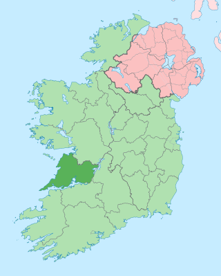
County Clare is a county in Ireland, in the Southern Region and the province of Munster, bordered on the west by the Atlantic Ocean. Clare County Council is the local authority. The county had a population of 127,938 at the 2022 census. The county seat and largest settlement is Ennis.

<span class="mw-page-title-main">Dromineer</span> Village in Munster, Ireland

Dromineer is a small village and townland in County Tipperary, Ireland. It is situated on the shores of Lough Derg on the River Shannon. The village is located 10 km north of Nenagh on the R495 road. It is a civil parish in the historical barony of Ormond Lower. Historic documents describe the places as "Dromynnyre"; the earliest form of the name dating from 1302 was Dromynwyr.

<span class="mw-page-title-main">Bunratty Castle</span> Castle in Ireland

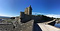
Bunratty Castle is a large 15th-century tower house in County Clare, Ireland. It is located in the centre of Bunratty village, by the N18 road between Limerick and Ennis, near Shannon Town and its airport. The castle and the adjoining folk park are run by Shannon Heritage as tourist attractions.

<span class="mw-page-title-main">Castleconnell</span> Village in County Limerick, Ireland

Castleconnell is a village in County Limerick on the banks of the River Shannon. It is 11 km (6.8 mi) from Limerick city and near the boundaries of County Clare and County Tipperary.

<span class="mw-page-title-main">Kilrush</span> Town in County Clare, Ireland

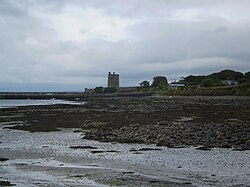
Kilrush is a coastal town in County Clare, Ireland. It is also the name of a civil parish and an ecclesiastical parish in Roman Catholic Diocese of Killaloe. It is located near the mouth of the River Shannon in the south-west of the county. Kilrush is one of the listed Heritage Towns of Ireland. The area was officially classified as part of the West Clare Gaeltacht, an Irish-speaking community, until 1956.

<span class="mw-page-title-main">Clarecastle</span> Village in County Clare, Ireland

Clarecastle is a village just south of Ennis in County Clare, Ireland. From 2008 to 2016 the village saw a significant population increase due to its proximity to Ennis, Shannon, and Limerick.

<span class="mw-page-title-main">O'Brien's Bridge</span> Village in County Clare, Ireland

O'Brien's Bridge or O'Briensbridge is a village in east County Clare, Ireland, on the west bank of the River Shannon, in a civil parish of the same name. It is named for the bridge across the Shannon at that point, built by Turlough O'Brien in 1506.

<span class="mw-page-title-main">Doonagore Castle</span> Tower house in County Clare, Ireland

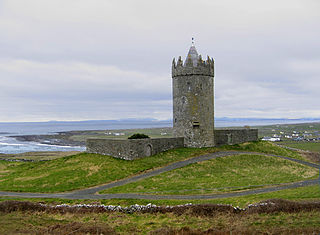
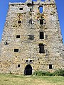
Doonagore Castle is a round 16th-century tower house with a small walled enclosure located about 1 km south of the coastal village of Doolin in County Clare, Ireland. Its name may be derived from Dún na Gabhair, meaning "the fort of the rounded hills" or the "fort of the goats". Doonagore Castle is at present a private holiday home, inaccessible to the public.

<span class="mw-page-title-main">Corofin, County Clare</span> Town in County Clare, Ireland

Corofin is a town on the River Fergus in northern County Clare, Ireland and also a parish of the same name in the Catholic Diocese of Killaloe.

<span class="mw-page-title-main">Kildysart</span> Village in County Clare, Ireland

Kildysart, officially Killadysert, is a large village in County Clare, Ireland and a civil and Roman Catholic parish by the same name that surrounds the village.

<span class="mw-page-title-main">Shannon Estuary</span> River in Kerry, Ireland

The Shannon Estuary in Ireland is a large estuary where the River Shannon flows into the Atlantic Ocean. The estuary has Limerick City at its head and its seaward limits are marked by Loop Head to the north and Kerry Head to the south. The estuary defines the main boundary between County Kerry/County Limerick to the south and County Clare to the north.

<span class="mw-page-title-main">Ballynacally</span> Village in County Clare, Ireland

Ballynacally is a village and townland situated 16.7 km (10.4 mi) southwest of Ennis, on the R473 coast road to Kilrush in the civil parish of Kilchreest, County Clare, Ireland. It lies near the bank of the River Shannon.

<span class="mw-page-title-main">Labasheeda</span> Village in County Clare, Ireland

Labasheeda is a village in the parish of Kilmurry McMahon in County Clare, Ireland. The village is set on a peninsula on the banks of the Shannon estuary.

<span class="mw-page-title-main">Kilbaha</span> Village in County Clare, Ireland

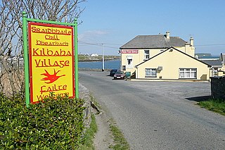
Kilbaha is a small fishing village in County Clare, Ireland. It is located close to the western end of the Loop Head peninsula on the R487 road.

The High Sheriff of Clare was a High Sheriff title. Records show that the title was in existence from at least the late 16th century, though it is not used today in the modern Republic of Ireland. The title existed within County Clare in the west of Ireland during the time of the Kingdom of Ireland and then as part of the United Kingdom of Great Britain and Ireland.

Kilmurry McMahon, also called Kilmurry-Clonderalaw, is a civil parish in County Clare in Ireland. It is also a Catholic parish in the Diocese of Killaloe.

<span class="mw-page-title-main">Moyarta</span> Civil parish in County Clare, Ireland

Moyarta is a civil parish in County Clare, Ireland. It lies on the Loop Head peninsula between the Atlantic Ocean and the Shannon Estuary. The parish contains the villages of Carrigaholt and Doonaha.

<span class="mw-page-title-main">Kilseily</span> Civil parish in Munster, Ireland

Kilseily is a civil parish in County Clare, Ireland. The main settlement is the village of Broadford.

<span class="mw-page-title-main">Killofin</span> Parish in County Clare, Ireland

Killofin is a civil parish in County Clare in Ireland. It contains the village of Labasheeda and is part of the Catholic parish of Kilmurry McMahon.

<span class="mw-page-title-main">Kilballyowen</span> Parish in County Clare, Ireland

Kilballyowen is the name of both a civil parish and a townland within that parish in County Clare, Ireland. The name is also occasionally used for the slightly larger Catholic parish of Cross.

References

  1. "Carraig an Chabhaltaigh/Carrigaholt". Placenames Database of Ireland (logainm.ie). Retrieved 21 October 2021.
  2. "Carrigaholt". Diocese of Killaloe. Retrieved 30 March 2014.