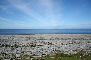
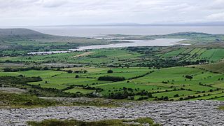
The Burren is a karst/glaciokarst landscape centred in County Clare, on the west coast of Ireland. It measures around 530 square kilometres (200 sq mi), within the circle made by the villages of Lisdoonvarna, Corofin, Gort and Kinvara. The area includes such natural features as Mullaghmore hill and Ailladie cliffs, and historic monuments such as Poulnabrone dolmen and Caherconnell Stone Fort. The Burren National Park covers a small part of the Burren and is the smallest of the six National Parks in Ireland, while the adjacent territory, including the Cliffs of Moher, is included in the Burren and Cliffs of Moher Geopark.

Kilfenora is a village and a civil parish in County Clare, Ireland. It is situated south of the karst limestone region known as the Burren. Since medieval times when it was the episcopal see of the Bishop of Kilfenora, it has been known as the "City of the Crosses" for its seven high crosses. The village had around 220 inhabitants in 2011. Much of the TV show Father Ted (1995–98) was filmed there.

Carran, also Carron, is a small village in County Clare, Ireland. It is in the Burren region, within a civil parish of the same name. It is notable mainly for being the birthplace of Michael Cusack, the inspirer and co-founder of the Gaelic Athletic Association. At the time of the 2011 Census, Carran had 106 inhabitants.
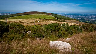
Kilmashogue or Kilmashoge is a mountain in Dún Laoghaire–Rathdown county in Ireland. It is 408 metres high and forms part of the group of hills in the Dublin Mountains which comprises Two Rock, Three Rock, Kilmashogue and Tibradden Mountains. The forest plantation on its northern slope, which is composed mainly of Sitka spruce, Scots pine and beech, is a habitat for Sika deer, hares, rabbits and foxes. A number of prehistoric monuments can be found on the slopes of the mountain.
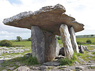
Poulnabrone dolmen is a large dolmen located in the Burren, County Clare, Ireland. Situated on one of the most desolate and highest points of the region, it comprises three standing portal stones supporting a heavy horizontal capstone, and dates to the Neolithic period, with estimates to between 4200 BC and 2900 BC. Although not the largest, it is the best known of the approximately 172 dolmens in Ireland.

Mushroom stones, or mushroom rocks, in Ireland are limestone boulders undercut by past weathering regimes. These rocks take the form of solitary sentinels of limestone which still bear the unmistakable marks of long-continued erosion by ice, soil or lapping waves at the edge of lakes which have since vanished or retreated. These stones are sometimes shaped like mushrooms, others have an overhang facing in just one direction, but all are notched and undercut in such a fashion as to suggest prolonged exposure to standing water at some time in the past. The mushroom-shaped stones are produced where the notching forms a fairly even circle around the stone.

Corcomroe Abbey is an early 13th-century Cistercian monastery located in the north of the Burren region of County Clare, Ireland, a few miles east of the village of Ballyvaughan in the Barony of Burren. It was once known as "St. Mary of the Fertile Rock", a reference to the Burren's fertile soil.
Megalithic monuments in Ireland typically represent one of several types of megalithic tombs: court cairns, passage tombs, portal tombs and wedge tombs. The remains of over 1,000 such megalithic tombs have been recorded around Ireland.

Kilnaboy or Killinaboy is a village, townland and civil parish in County Clare, Ireland. It is located in the Burren, and as of the 2011 census the area had 347 inhabitants.

Rathborney, sometimes Rathbourney, is a civil parish in the Barony of Burren in County Clare, Ireland.
Oughtmama is a civil parish in County Clare. It lies in the Burren, a region in the northwest of the county. It contains many antiquities, including three early-medieval Christian churches, ruined castles, prehistoric cairns and ring forts and two Martello Towers built in the early 19th century.

Killilagh or Killeilagh is a civil parish in County Clare, Ireland. It contains the village of Doolin.

Kilcorney is a civil parish in County Clare, Ireland. It lies in the Burren region of the northwest of the county.

Parknabinnia wedge tomb is a prehistoric wedge tomb located in the Burren area of County Clare, Ireland.

The Gleninsheen wedge tombs are two prehistoric wedge tombs located in the north central area of the Burren area of County Clare, Ireland. Both are aligned east-west, and there is evidence of contemporary etchings on some of the stone.

Poulawack Cairn is a prehistoric burial cairn located in the Burren area of County Clare, Ireland.

The Inneenboy cross or the Roughan Hill Tau Cross is a stone tau cross located in County Clare, Ireland. It is a National Monument.

Cashlaungar, also Cashlaungarr, Cashlaun Gar or Cashlán Gar, is a stone ringfort (cashel) and National Monument located in The Burren, a region in County Clare, Ireland.
Slievenaglasha wedge tomb is a wedge-shaped gallery grave and National Monument located in County Clare, Ireland.
Tullycommon Wedge Tomb is a wedge-shaped gallery grave and National Monument located in The Burren region of County Clare, Ireland.

