Carran

Last updated

Carran
An Carn
Village
St. Columba's Church, Carran.jpg
St. Columba's Church
Ireland adm location map.svg
Red pog.svg
Carran
Location in Ireland
Coordinates: 53°02′06″N9°04′35″W / 53.0350°N 9.0763004°W / 53.0350; -9.0763004
CountryIreland
Province Munster
County County Clare
Population
 (2011) [1]
  Total106
Time zone UTC+0 (WET)
  Summer (DST) UTC-1 (IST (WEST))
Irish Grid Reference R277992
Carran painted in the first half of the 19th century by a travelling French artist DV405 no. Carran Tual.png
Carran painted in the first half of the 19th century by a travelling French artist
Temple Cronan Exterior Temple Cronan.JPG
Temple Cronan
Carran church Carran-church-ruins.jpg
Carran church
Cassidy's Cassidy's pub and restaurant, Carran, Co. Clare - geograph.org.uk - 250624.jpg
Cassidy's

Carran (Irish : An Carn, meaning 'the cairn '), [2] also Carron, is a small village in County Clare, Ireland. It is in the Burren region, within a civil parish of the same name. It is notable mainly for being the birthplace of Michael Cusack, the inspirer and co-founder of the Gaelic Athletic Association. At the time of the 2011 Census, Carran had 106 inhabitants.

Contents

Geography

Carran parish is located on the uplands of the Burren and is bounded on the northwest by County Galway and on the south by Kilnaboy. Slieve Carran, one of the highest points in the Burren, lies north of the village.

The land is mainly rocky pasture with much limestone. In the past there were copper mines. It is said that Saint Columb founded an abbey at Glanculmkil, later to become the parish church. An 1837 account said this church was in ruins, and there were the remains of two other old churches at Crunane and Glanculmkil. A stone bed is called Saint Columb's bed, and nearby is a spring of fine water. [3]

The parish contains the townlands of Ballyconry, Ballydoora, Ballyline, Cahermackirilla, Cahergrillaun, Cappagh, Cappaghkennedy, Carran, Castletown, Clab, Clooncoose, Commons, Coolnatullagh, Coskeam, Creevagh, Crughwill, Fahee North, Fahee South, Fanygalvan, Glencolumbkille North, Glencolumbkille South, Iskancullin, Keelhilla, Knockans Lower, Knockans Upper, Meggagh East, Meggagh West, Mogouhy, Moheramoylan, Moheraroon, Moygowna, Poulacarran, Poulaphuca, Poulawack, Poulcaragharush, Pullagh, Rannagh East, Rannagh West, Sheshodonnell East, Sheshodonnell West, Sladoo and Termon. [4]

Economy

In the village itself, a pub/restaurant (Cassidy's), a hostel, and a number of bed and breakfasts can be found. It also sports a church, a schoolhouse (built in 1858) [5] :24 and a town hall. The schoolhouse now is used by the "Burrenlife Project". [6]

The number of inhabitants was 106 at the time of the 2011 Census, down from 115 in 2006. [1]

Carran is located centrally to a number of tourist sights: Within eight kilometres of the village are several stone forts, Poulnabrone dolmen, a turlough (disappearing lake) and limestone scenery ("pavement"). There is also Gleann Ciosog (a Gaelic Athletic Association pitch for the local football team Michael Cusacks). Carran was the birthplace of Michael Cusack, the inspirer and co-founder of the Gaelic Athletic Association. A visitor centre commemorating him has been constructed south of the village on road L1014. [7]

East of the village is a Field Research Station, opened in 1975 by University College Galway (now NUI Galway). [5] :95 A bit beyond is the "Burren Perfumery", according to Lonely Planet the "only handycraft perfumery in Ireland". [8]

In addition, the area offers walking trails like the "Carran loop" or around the Carran turlough and scenic views over the Burren. [5] :22–31,92–97 [9]

Places of interest

See also

Related Research Articles

<span class="mw-page-title-main">The Burren</span> Glaciated karst landscape region in northwest County Clare, Ireland

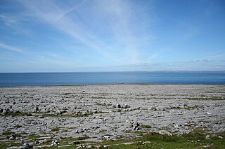
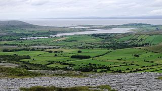
The Burren is a karst/glaciokarst landscape centred in County Clare, on the west coast of Ireland. It measures around 530 square kilometres (200 sq mi), within the circle made by the villages of Lisdoonvarna, Corofin, Gort and Kinvara. The area includes such natural features as Mullaghmore hill and Ailladie cliffs, and historic monuments such as Poulnabrone dolmen and Caherconnell Stone Fort. The Burren National Park covers a small part of the Burren and is the smallest of the six National Parks in Ireland, while the adjacent territory, including the Cliffs of Moher, is included in the Burren and Cliffs of Moher Geopark.

<span class="mw-page-title-main">Kilfenora</span> Village in County Clare, Ireland

Kilfenora is a village and a civil parish in County Clare, Ireland. It is situated south of the karst limestone region known as the Burren. Since medieval times when it was the episcopal see of the Bishop of Kilfenora, it has been known as the "City of the Crosses" for its seven high crosses. The village had around 220 inhabitants in 2011. Much of the TV show Father Ted (1995–98) was filmed there.

<span class="mw-page-title-main">Ballyvaughan</span> Harbour village in County Clare, Ireland

Ballyvaughan or Ballyvaghan is a small harbour village in County Clare, Ireland. It is located on the N67 road on the south shores of Galway Bay, in the northwest corner of The Burren. This position on the coast road and the close proximity to many of the area's sights has turned the village into a local center of tourism activity. At the time of the 2011 census Ballyvaughan had a population of 258. The area was officially classified as part of the West Clare Gaeltacht, an Irish-speaking community, until 1956.

<span class="mw-page-title-main">Michael Cusack (Gaelic Athletic Association)</span> Founder of the Gaelic Athletic Association

Michael Cusack was an Irish teacher and founder of the Gaelic Athletic Association.

<span class="mw-page-title-main">Corofin, County Clare</span> Town in County Clare, Ireland

Corofin is a town on the River Fergus in northern County Clare, Ireland and also a parish of the same name in the Catholic Diocese of Killaloe.

<span class="mw-page-title-main">Kilshanny</span> Village and parish in County Clare, Ireland

Kilshanny is a village and a civil parish in County Clare, Ireland.

<span class="mw-page-title-main">Caherconnell Stone Fort</span> Medieval stone ringfort in the Burren, County Clare, Ireland.

Caherconnell is an exceptionally well-preserved medieval stone ringfort in region known as the Burren, County Clare, Ireland. It lies about 1 km south of the Poulnabrone dolmen.

<span class="mw-page-title-main">Kilnaboy</span> Village in County Clare, Ireland

Kilnaboy or Killinaboy is a village, townland and civil parish in County Clare, Ireland. It is located in the Burren, and as of the 2011 census the area had 347 inhabitants.

<span class="mw-page-title-main">Temple Cronan</span> Historic site in County Clare, Ireland

Temple Cronan is a ruined medieval oratory or chapel built near a holy well in the Burren, County Clare, Ireland. The current building apparently dates from the 12th and 15th centuries, although it may partly incorporate earlier buildings or some of the masonry thereof. It may have been the site of an early Christian monastery. Temple Cronan is located in the civil parish of Carran, eight miles from Corofin and about sixteen miles from Ennis.

<span class="mw-page-title-main">Dromore, County Clare</span>

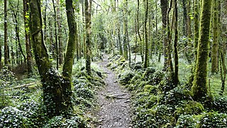
Dromore, County Clare is a rural townland in County Clare in the Republic of Ireland. It is located in the parish of Ruan and was formerly the location of Dromore House. Today, most of the townland is accounted for by Dromore Wood Nature Reserve. It is open to the public and also contains the ruins of Dromore Castle.

<span class="mw-page-title-main">Oughtmama</span> Civil parish in County Clare, Ireland

Oughtmama is a civil parish in County Clare. It lies in the Burren, a region in the northwest of the county. It contains many antiquities, including three early-medieval Christian churches, ruined castles, prehistoric cairns and ring forts and two Martello Towers built in the early 19th century.

<span class="mw-page-title-main">Killilagh</span> Civil parish in County Clare, Ireland

Killilagh or Killeilagh is a civil parish in County Clare, Ireland. It contains the village of Doolin.

<span class="mw-page-title-main">Noughaval</span> Civil parish in County Clare, Ireland

Noughaval or Nohoval is a civil parish in County Clare, Ireland.

<span class="mw-page-title-main">Gleninagh</span> Parish in County Clare, Ireland

Gleninagh or Glaninagh is a civil parish in County Clare, Ireland. It lies in the extreme northwest of the Burren, on the south of the mouth of Galway Bay. It is known for the well-preserved L-plan Gleninagh Castle, a 16th-century tower house. The parish also contains the lighthouse on Black Head.

<span class="mw-page-title-main">Drumcreehy</span> Parish in Munster, Ireland

Drumcreehy or Dromcreehy is a civil parish in County Clare, Ireland. It contains the village of Ballyvaughan.

<span class="mw-page-title-main">Kilcorney, County Clare</span> Civil parish in County Clare, Ireland

Kilcorney is a civil parish in County Clare, Ireland. It lies in the Burren region of the northwest of the county.

<span class="mw-page-title-main">Creevagh (wedge tomb)</span> Prehistoric Irish wedge tomb

Creevagh wedge tomb is a prehistoric wedge tomb located in the Burren area of County Clare, Ireland.

<span class="mw-page-title-main">Gleninsheen (wedge tomb)</span>

The Gleninsheen wedge tombs are two prehistoric wedge tombs located in the north central area of the Burren area of County Clare, Ireland. Both are aligned east-west, and there is evidence of contemporary etchings on some of the stone.

<span class="mw-page-title-main">Cashlaungar</span>

Cashlaungar, also Cashlaungarr, Cashlaun Gar or Cashlán Gar, is a stone ringfort (cashel) and National Monument located in The Burren, a region in County Clare, Ireland.

Tullycommon Wedge Tomb is a wedge-shaped gallery grave and National Monument located in The Burren region of County Clare, Ireland.

References

  1. 1 2 "Census 2011". Central Statistics Office Ireland . Retrieved 15 December 2013.
  2. "An Carn/Carran". Placenames Database of Ireland (logainm.ie). Retrieved 21 October 2021.
  3. Samuel Lewis (1837). "Carrune, Carron or Carne". County Clare: A History and Topography . Retrieved 8 March 2014.
  4. "Map of Carran Parish showing Townlands". Clare County Library. Retrieved 8 March 2014.
  5. 1 2 3 Kirby, Tony (2011). The Burren & The Aran Islands - A walking guide. The Collins Press. ISBN   9781905172979.
  6. "Burren Life Project website" . Retrieved 15 December 2013.
  7. "Michael Cusack Visitor Centre". Michael Cusack Visitor Centre. Retrieved 15 December 2013.
  8. "Burren Perfumery". Lonely Planet. Retrieved 15 December 2013.
  9. "Carran Looped Walk". Discover Island/Failte Ireland. Retrieved 15 December 2013.
  10. Cunningham, George (1978). Burren Journey. Shannonside Mid Western Regional Tourism Organisation.
  11. Carthy, Hugh (2011). Burren Archaeology. The Collins Press. ISBN   9781848891050.