
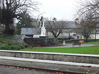
Scarriff or Scariff is a large village in east County Clare, Ireland, situated in the midwest of Ireland. The town is on the West end of Lough Derg and is best known for its harbour. The Scarriff Market House is easily recognisable, and it is therefore often used to represent the town.
Tuamgraney is a village in eastern County Clare in the west of Ireland and a civil parish by the same name. Situated a kilometre from the River Graney which flows into Lough Derg, it is an ancient settlement, noted for St Cronán's Church, said to be the oldest church in constant use in Ireland

Doora is a civil parish and village in County Clare, Ireland, just to the east of the town of Ennis. It is part of the Catholic parish of Doora Barefield. Parts of Doora are contained in the town of Ennis.

Kilmaley is a village situated 12 kilometres (7.5 mi) west of the town of Ennis, County Clare, Ireland. The name "Kilmaley" came from the Irish language "Cill Mhaile" which translates to Church of (Saint) Maley.

Clonlea or Clonleigh is a civil parish in County Clare, Ireland. The main settlement is the village of Kilkishen. It is part of the Catholic parish of O'Callaghans Mills.
Drumline is a civil parish of County Clare, Ireland, located about 20 kilometres (12 mi) northwest of Limerick, just north of Shannon.
Templemaley is a civil parish in County Clare, Ireland. It contains the village of Barefield and part of the town of Ennis.

Kilseily is a civil parish in County Clare, Ireland. The main settlement is the village of Broadford.
Kiltenanlea or Kiltonanlea is a civil parish in County Clare, Ireland.
Kilchreest is a civil parish of County Clare, Ireland. It contains the village of Ballynacally and is part of the Roman Catholic parish of Ballynacally (Clondegad), which includes the civil parish of Clondagad to the north.
Kilnoe is a civil parish in County Clare, Ireland. It is a rural area, part of the Roman Catholic parish of Bodyke.

Killofin is a civil parish in County Clare in Ireland. It contains the village of Labasheeda and is part of the Catholic parish of Kilmurry McMahon.

Kilfarboy is a parish in County Clare and part of the Roman Catholic Diocese of Killaloe in Ireland. There is also a civil parish with the same name. The largest population centre in the parish is Milltown Malbay.
Crusheen, formerly called Inchicronan, is a civil parish in County Clare, Ireland. There is also a catholic parish Crusheen, covering the same area. The parish lies to the northeast of Ennis. It contains the villages of Crusheen and Ballinruan.
Killeely is a civil parish that lies partly in County Clare and partly in County Limerick in Ireland.

Inishcaltra is a civil parish in the barony of Leitrim in County Clare, Ireland. The main settlement in the parish is the village of Mountshannon. It is noted for the eponymous island of Inis Cealtra, which is an ancient Christian monastic site. In the Catholic Church, the parish is part of the ecclesiastical parish of Mountshannon (Clonrush).
Clonrush or Clonmulsk is a civil parish in the barony of Leitrim, now in County Clare, Ireland. The largest settlement in the parish is Whitegate. In the Catholic Church, the parish is joined with Mountshannon.
Killuran is a civil parish in County Clare, Ireland. It contains the village of O'Callaghans Mills. It is united with the civil parish of Kilkishen in the Catholic parish of O'Callaghans Mills.
Kiltoraght is a civil parish in County Clare, Ireland. It is just south of Kilfenora and is part of Catholic parish of Kilfenora.
Killaspuglonane is a civil parish in County Clare, Ireland.
