Gleninagh

Last updated

Gleninagh
Gleann Eidhneach
Parish
GleninaghCastle-Ireland-14.06.2002.jpg
Gleninagh Castle
Ireland adm location map.svg
Red pog.svg
Gleninagh
Coordinates: 53°08′25″N9°13′31″W / 53.140284°N 9.22539°W / 53.140284; -9.22539
Country Ireland
Province Munster
County County Clare, County Limerick
Time zone UTC+0 (WET)
  Summer (DST) UTC-1 (IST (WEST))
Designations
Official nameGleninagh Castle
Reference no.509

Gleninagh or Glaninagh (Irish : Gleann Eidhneach [1] ) is a civil parish in County Clare, Ireland. It lies in the extreme northwest of the Burren, on the south of the mouth of Galway Bay. It is known for the well-preserved L-plan Gleninagh Castle, a 16th-century tower house. The parish also contains the lighthouse on Black Head.

Contents

Name

Gleann Eidhneach means the valley of ivy. [2] However, it is possible that the correct Irish name is actually Cluain Eidhneach or "ivied retreat". The name predates the castle (see below). Parishes were often named after the principal church and this may be the case here. [3] :86–7

Location

The parish is in the northwest corner of the Barony of Burren. It is 13 miles (21 km) north of Ennistymon. The parish is 2 by 0.75 miles (3.22 by 1.21 km) and covers 4,292 acres (1,737 ha). It contains the bold cape of Black Head with its lighthouse, at the south side of the entrance to Galway bay. The land is broken and mountainous. [4]

Antiquities

Castle

Gleninagh Castle Gleninagh Castle - geograph.org.uk - 65579.jpg
Gleninagh Castle

The 16th-century Gleninagh Castle, an L-shaped tower house, stands on a hillside looking out over Galway Bay. [5]

It was an O'Loghlen (or O'Loughlin) stronghold from the early 16th century. Although it changed hands many times over the next centuries it was eventually regained by the family who used it until c. 1840. In 1839, it was described as "in good repair". A visitor in 1843 said the castle was being used as a barn by Mr. Blood, its proprietor. The upper part of the building was used as a dove-cot and abounded in pigeons. [6] [3] :88

The tower measures 31.8 feet (9.7 m) by 27.6 feet (8.4 m). In 1839 it was thatched with straw. [7] There are four stories. The single square turret contains a spiral stairway. The entrance doorway on the first floor of the turret is protected by a machicolation high above. There are round bartizans in three of the main tower's corners. A number of window openings in the end wall were later closed (likely in the late 16th or early 17th century) so they could be used for fireplaces. [5] [3] :88

Church

Interior of Gleninagh Church Glenina Church inside.jpg
Interior of Gleninagh Church

The medieval church is of indeterminate age, but was in existence by 1302 (according to tax lists). There are some indications that the site may have been an earlier monastic settlement, such as a curved field wall shown on the 1842 OS map which could have been a remainder of a typical monastic enclosure wall. Domestic waste was discovered near the church and there are other signs of habitation such as outbuildings. Absent excavation, however, the age of the ecclesiastical site remains uncertain. [3] :86,88

The church was described in 1839 as being mantled in thick ivy. The floor measured 38 by 13.33 feet (11.58 by 4.06 m). The walls were 2.5 feet (0.76 m) thick and about 8 feet (2.4 m) high. The south wall had a pointed doorway of cut stone that was 5.33 feet (1.62 m) high, measured to the vertex of the arch, and 3.1 feet (0.94 m) wide. The south wall had two windows, one quadrangular and the other round-topped, both fairly recent. There was a window in the east gable about 8 feet (2.4 m) high and 3.66 feet (1.12 m) wide. In the outside the window opening was 5.5 inches (140 mm). [7]

As of 1897, the church was in a good state of preservation. [2]

Today, though in poor repair, it is accessible to the public by a footpath from the road. The church is small for a parish church, which probably reflects the small population and poverty of the area which may well have been the poorest parish of the diocese of Kilfenora. [3] :87

Gleninagh Lodge

The partially overgrown remains of this structure lie at the end of the lane connecting the road to the tower house. Mid-19th century maps show a substantial assembly of large buildings. The estate included a large formal garden south of the holy well. At the time, most of the land in this area was owned by the lodge's proprietor, William Bindon Blood, a descendant of Colonel Thomas Blood, who tried to steal the English Crown Jewels in 1671. [3] :91

Others

Tobar na Croiche Naoimhe (Well of the Holy Cross) Tobar na Croiche Naoimhe, a well near Gleninagh Castle in The Burren. - geograph.org.uk - 65186.jpg
Tobar na Croiche Naoimhe (Well of the Holy Cross)

Near the castle is a holy well dedicated to the Holy Cross, which has many recorded names (Tobar na Croiche Naoimh, Croghneva, Tobar na Croise Naomhtha, Tobernacrobaneede etc.). The well has a little stone vault over it, with a Gothic-type arch and a cross on top. It was thought that performing stations at the well would help with problems with the eyes. In the early 1840s the votive offerings were reported to include human skulls. At least until that period the well was a destination for pilgrims.

Tobar Cornain Tobercornan Well, holy well near Glenina.jpg
Tobar Cornain

Another well called Tobar Cornain (or Tobercornan) is in the townland of Gleninagh North. [7] [3] :90–1 This is today covered by a Gothic Revival well house (c. 1860) and lies right next to the road. [8]

There is a large heap of stones called Dough Branneen ("the heap of little Bran") in the townland of Aughaglinny. There is a stone ringfort called Caher doon Fergus in the townland of Murroogh with caves underneath it, said to be haunted. [2]

East of the castle is a lime kiln, previously thought to be a Fulacht Fiadh . [9] :32 [3] :90

History

In 1544 King Henry VIII of England granted Gleninagh to Richard Harding. The castle was owned by James Lynch of Galway in 1570. The lands of Gleninagh were owned by the see of Kilfenora in 1629. [10]

In 1837 a parish was in the Catholic union or district of Glyn, or Glenarraha. [11] The population in 1841 was 886 in 146 houses. In 1845 the main settlements were the villages of Glaninagh, Murroghkelly and Murroghwohy. [4]

Townlands

Townlands are Aghaglinny North, Aghaglinny South, Gleninagh North, Gleninagh South, Murrooghkilly, Murrooghtoohy North and Murrooghtoohy South. [12]

Related Research Articles

<span class="mw-page-title-main">Kilfenora</span> Village in County Clare, Ireland

Kilfenora is a village and a civil parish in County Clare, Ireland. It is situated south of the karst limestone region known as the Burren. Since medieval times when it was the episcopal see of the Bishop of Kilfenora, it has been known as the "City of the Crosses" for its seven high crosses. The village had around 220 inhabitants in 2011. Much of the TV show Father Ted (1995–98) was filmed there.

<span class="mw-page-title-main">Carran</span> Village in County Clare, Ireland

Carran, also Carron, is a small village in County Clare, Ireland. It is in the Burren region, within a civil parish of the same name. It is notable mainly for being the birthplace of Michael Cusack, the inspirer and co-founder of the Gaelic Athletic Association. At the time of the 2011 Census, Carran had 106 inhabitants.

<span class="mw-page-title-main">Kilshanny</span> Village and parish in County Clare, Ireland

Kilshanny is a village and a civil parish in County Clare, Ireland.

<span class="mw-page-title-main">Tubber, County Clare</span> Village in County Clare, Ireland

Tubber is a village in the north of County Clare, Ireland.

<span class="mw-page-title-main">Kilfenora Cathedral</span> Church in County Clare, Ireland

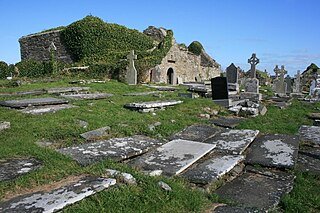
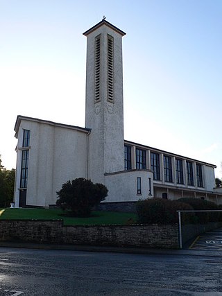
Kilfenora Cathedral is a cathedral of the Church of Ireland. Part of the structure is occasionally used as a place of worship by the Church of Ireland and it includes a bishop's throne among its furniture. The church is located in the village of Kilfenora, in the region known as the Burren, County Clare, Ireland. In medieval times, it was the episcopal see of the Bishop of Kilfenora.

<span class="mw-page-title-main">Newtown Castle</span> Tower house, County Clare, Ireland

Newtown Castle is a 16th-century tower house, located close to the village of Ballyvaughan within the Burren area of County Clare, Ireland. Uniquely for a tower house of its type in Ireland, Newtown Castle is mostly cylindrical in shape but rises from a square pyramidical base. It is today part of the Burren College of Art.

Kilmoon is a civil parish of County Clare, Ireland, 7 miles (11 km) north of Ennistymon. The parish contains the town of Lisdoonvarna.

<span class="mw-page-title-main">Kilmacrehy</span> Civil parish in Clare, Ireland

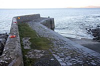
Kilmacrehy, sometimes also Kilmacreehy, is a civil parish in County Clare, Ireland. The ruins of the old parish church lie near the coastal village of Liscannor, which is also a part of the parish.

<span class="mw-page-title-main">Rathborney</span> Civil parish in Clare, Ireland

Rathborney, sometimes Rathbourney, is a civil parish in the Barony of Burren in County Clare, Ireland.

Tubber is a small village located in the south of County Galway, Ireland.

<span class="mw-page-title-main">Dysart and Ruan</span> Catholic parish in County Clare, Ireland

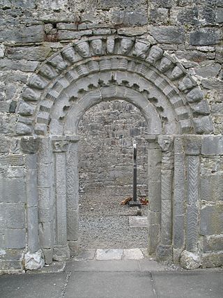
Dysart and Ruan is a Catholic parish in County Clare, Ireland. It covers the civil parishes of Ruan and Dysert, and includes the village of Ruan, which holds the parish office. The parish contains the ruins of the 12th century St. Tola's Church, part of Dysert O'Dea Monastery.

<span class="mw-page-title-main">Oughtmama</span> Civil parish in County Clare, Ireland

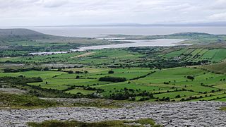
Oughtmama is a civil parish in County Clare. It lies in the Burren, a region in the northwest of the county. It contains many antiquities, including three early-medieval Christian churches, ruined castles, prehistoric cairns and ring forts and two Martello Towers built in the early 19th century.

<span class="mw-page-title-main">Killilagh</span> Civil parish in County Clare, Ireland

Killilagh or Killeilagh is a civil parish in County Clare, Ireland. It contains the village of Doolin.

<span class="mw-page-title-main">Noughaval</span> Civil parish in County Clare, Ireland

Noughaval or Nohoval is a civil parish in County Clare, Ireland.

Kiltoraght is a civil parish in County Clare, Ireland. It is just south of Kilfenora and is part of Catholic parish of Kilfenora.

<span class="mw-page-title-main">Drumcreehy</span> Parish in Munster, Ireland

Drumcreehy or Dromcreehy is a civil parish in County Clare, Ireland. It contains the village of Ballyvaughan.

<span class="mw-page-title-main">Kilmanaheen</span> Civil parish in County Clare, Ireland

Kilmanaheen is a civil parish in County Clare, Ireland. It contains the market town of Ennistymon.

Killeany or Kilhenny, Kilheny is a civil parish in County Clare, Ireland. It lies in the Burren region of the northwest of the county.

<span class="mw-page-title-main">Kilcorney, County Clare</span> Civil parish in County Clare, Ireland

Kilcorney is a civil parish in County Clare, Ireland. It lies in the Burren region of the northwest of the county.

<span class="mw-page-title-main">Inagh and Kilnamona</span> Catholic parish in County Clare, Ireland

Inagh and Kilnamona is a parish of the Roman Catholic Diocese of Killaloe in County Clare, Ireland. It is mostly coterminous with the civil parishes of Inagh and Kilnamona that lie to the west of the county town of Ennis in the ancient barony of Inchiquin. The parish contains two churches and an oratory.

References

Citations

  1. Gleann Eidhneach, Placenames Database of Ireland.
  2. 1 2 3 Frost 1897.
  3. 1 2 3 4 5 6 7 8 Carthy, Hugh (2011). Burren Archaeology. The Collins Press. ISBN   9781848891050.
  4. 1 2 Parliamentary Gazetteer of Ireland 1845.
  5. 1 2 Gleninagh Castle, Clare Tourism Forum.
  6. Cooke 1843.
  7. 1 2 3 O'Donovan 1839.
  8. "Tobercornan Well, County Clare". National Inventory of Architectural Heritage. Retrieved 23 September 2016.
  9. Roche, D. The Clare Guide - Official Irish Tourist Board Guide. Bord Failte.
  10. Breen 2014.
  11. Lewis 1837.
  12. Map of Gleninagh Parish showing Townlands.

Sources