Burren (barony)

Last updated

Barony of Burren
Irl Finavarra Martello Tower.jpg
Ireland adm location map.svg
Red pog.svg
Barony of Burren
Coordinates: 53°04′06″N9°11′02″W / 53.06822°N 9.183887°W / 53.06822; -9.183887
Country Ireland
Province Munster
County Clare
Baronies of Clare. Burren is the furthest north. Baronies of Clare.jpg
Baronies of Clare. Burren is the furthest north.

The Barony of Burren is a geographical division of County Clare, Ireland, that in turn is divided into civil parishes. It covers a large part of the Burren.

Contents

Baronies were created after the Norman invasion of Ireland as divisions of counties and were used the administration of justice and the raising of revenue. While baronies continue to be officially defined units, they have been administratively obsolete since 1898. However, they continue to be used in land registration and in specification, such as in planning permissions. In many cases, a barony corresponds to an earlier Gaelic túath which had submitted to the Crown.

Landscape

The Parliamentary Gazetteer of Ireland 1845 describes the barony as follows: [1]

A maritime barony of County Clare, Munster. It is bounded, on the north, by Galway bay; on the east, by County Galway and the barony of Inchiquin; on the south, by the baronies of Inchiquin and Corcomroe; and on the west, by the South Sound, which separates it from the Arran Islands. Its greatest length, from east to west, is 15 miles; its greatest breadth, from north to south, is 9 miles; and its area is 74,361 acres.

The general features of the greater part of the barony of Burrin, are altogether different from those of any other part of the country. In the central portion of this district, the entire surface seems one unbroken mass of limestone rock; and the bare hills, rising from the shore to a great elevation, in regularly receding terraced flights, present a vast amphitheatrical outline. The disjointed blocks, composing the surface of this immense concavity, though not deposited with all the precision of the trap rocks, are laid generally in horizontal lines, giving to the whole, at a distance, a regular and formal character.

The more elevated parts are destitute of herbage, and present to the eye an arid, cold, and joyless waste, unchanged by either summer's sun or winter's cold, and but little varied by either light or shade." [Fraser's Guide.] Yet the upland grounds, though extremely rocky, produce a short sweet herbage; and annually nourish vast numbers of sheep for the great fair of Ballinasloe. The west coast presents a gently curved line to the sea; and the north coast is intricately indented by the ramifications of Blackhead bay. The streams are all indigenous and inconsiderable. [1]

History

The district was once called Cean-gan, which means "the external promontory". Ptolemy wrote this name as Gan-ganii.[ citation needed ] Later it was called Hy-Loch-Lean, which means "the district on the waters of the sea". In 1841 the population of the barony was 12,786 in 2,056 houses, mostly engaged in agriculture. [1]

Parishes and settlements

The barony contains the civil parishes of Abbey, Carran, Drumcreehy, Glaninagh, Kilcorney, Kilonahan, Kilheny, Kilmoon, Noughoval, Oughtmama, and Rathborney. It contains the settlements of Abbey, Burren, Behagh, Bealaclugga, Currenroe, Ballyvaughan, Ballyconree, Ballinacraggy, Loughrusk, Gleninagh, Murroghkelly, Murroghtwohy, Fermoyle, New Quay, Noughaval, Aughnish and Finavara. [1]

Related Research Articles

<span class="mw-page-title-main">Inagh</span> Village in County Clare, Ireland

Inagh is a village and civil parish in County Clare, Ireland. It is situated 14 km west of Ennis on the Inagh River. It contains the villages of Inagh and Cloonanaha.

<span class="mw-page-title-main">Kilfenora</span> Village in County Clare, Ireland

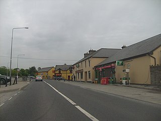
Kilfenora is a village and a civil parish in County Clare, Ireland. It is situated south of the karst limestone region known as the Burren. Since medieval times when it was the episcopal see of the Bishop of Kilfenora, it has been known as the "City of the Crosses" for its seven high crosses. The village had around 220 inhabitants in 2011. Much of the TV show Father Ted (1995–98) was filmed there.

<span class="mw-page-title-main">Corofin, County Clare</span> Town in County Clare, Ireland

Corofin is a town on the River Fergus in northern County Clare, Ireland and also a parish of the same name in the Catholic Diocese of Killaloe.

East Clare was a UK Parliament constituency in Ireland, returning one Member of Parliament (MP) from 1885 to 1922.

<span class="mw-page-title-main">Clonderalaw</span> Historical barony in County Clare, Ireland

Clonderalaw is an historical barony in County Clare, Ireland. Baronies are geographical divisions of land that are in turn is divided into civil parishes.

Bunratty Upper is a barony in County Clare, Ireland. This ancient geographical division of land is in turn divided into six civil parishes.

<span class="mw-page-title-main">Tulla Upper</span> Place in Munster, Ireland

Tulla Upper is a barony in County Clare, Ireland. This ancient geographical division of land is in turn divided into seven civil parishes.

<span class="mw-page-title-main">Islands (barony)</span> Place in Munster, Ireland

Islands(Irish: Na hOileáin) is a barony located in County Clare, Ireland. This ancient unit of land division is in turn divided into five civil parishes.

<span class="mw-page-title-main">Ibrickane</span> Barony of County Clare, Ireland

Ibrickane is one of the ancient baronies of Ireland. It is a geographical division of County Clare. It is sub-divided into four civil parishes.

Inchiquin is a barony in County Clare, Ireland. This geographical unit of land is one of 11 baronies in the county. Its chief town is Corofin. It is administered by Clare County Council.

<span class="mw-page-title-main">Rathborney</span> Civil parish in Clare, Ireland

Rathborney, sometimes Rathbourney, is a civil parish in the Barony of Burren in County Clare, Ireland.

<span class="mw-page-title-main">Oughtmama</span> Civil parish in County Clare, Ireland

Oughtmama is a civil parish in County Clare. It lies in the Burren, a region in the northwest of the county. It contains many antiquities, including three early-medieval Christian churches, ruined castles, prehistoric cairns and ring forts and two Martello Towers built in the early 19th century.

<span class="mw-page-title-main">Killilagh</span> Civil parish in County Clare, Ireland

Killilagh or Killeilagh is a civil parish in County Clare, Ireland. It contains the village of Doolin.

<span class="mw-page-title-main">Noughaval</span> Civil parish in County Clare, Ireland

Noughaval or Nohoval is a civil parish in County Clare, Ireland.

<span class="mw-page-title-main">Killonaghan</span> Parish in Munster, Ireland

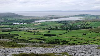
Killonaghan or Killonahan is a civil parish in County Clare, Ireland. It covers a part of the Burren, a rugged area on the Atlantic coast, and contains the seaside village of Fanore.

<span class="mw-page-title-main">Gleninagh</span> Parish in County Clare, Ireland

Gleninagh or Glaninagh is a civil parish in County Clare, Ireland. It lies in the extreme northwest of the Burren, on the south of the mouth of Galway Bay. It is known for the well-preserved L-plan Gleninagh Castle, a 16th-century tower house. The parish also contains the lighthouse on Black Head.

<span class="mw-page-title-main">Drumcreehy</span> Parish in Munster, Ireland

Drumcreehy or Dromcreehy is a civil parish in County Clare, Ireland. It contains the village of Ballyvaughan.

<span class="mw-page-title-main">Kilmanaheen</span> Civil parish in County Clare, Ireland

Kilmanaheen is a civil parish in County Clare, Ireland. It contains the market town of Ennistymon.

<span class="mw-page-title-main">Kilcorney, County Clare</span> Civil parish in County Clare, Ireland

Kilcorney is a civil parish in County Clare, Ireland. It lies in the Burren region of the northwest of the county.

<span class="mw-page-title-main">New Quay, County Clare</span> Village in County Clare, Ireland

New Quay or Newquay is a small coastal settlement in County Clare, Ireland. It takes its name from the quay built at this point on Galway Bay in the 19th century. New Quay is in the civil parish of Abbey and the historical barony of Burren. It is within the ecclesiastical parish of Carron & New Quay in the Roman Catholic Diocese of Galway, Kilmacduagh and Kilfenora. The former holiday home of Lady Gregory, Mount Vernon Lodge, is located in a neighbouring townland, also called New Quay. In the ITA Topographical and General Survey, published by the Irish Tourist Association in 1942, New Quay is described as "scarcely [..] a village as the houses are very scattered. However there is a Guards station, a P.O., and two shops". A pub and restaurant on the quayside, Linnane's Bar, is located in the former post office building.

References

Citations

  1. 1 2 3 4 Parliamentary Gazetteer of Ireland 1845.

Sources