Kilmacrehy, sometimes also Kilmacreehy, (Irish: Cill Mhic Creiche)[1] is a civil parish in County Clare, Ireland. The ruins of the old parish church lie near the coastal village of Liscannor, which is also a part of the parish.
Kilmacrehy is part of the historical Barony of Corcomroe. It is about 4 miles (6.4km) to the west of Ennistymon. It is on the north shore of Liscannor Bay on the western coast of Clare. The parish makes up the peninsula that extends to the basaltic promontory called Hag's Head. From this point the Cliffs known as the Cliffs of Moher run to the northeast gradually rising to O'Brien's Tower,[lower-alpha 1] where they are about 600 feet (180m) above sea level.[3]
Dough townland is the only part of the parish that lies on the south bank of the estuary of the Inagh River.
The parish once had the alias of Quoranna, meaning "the distinct projection", an allusion to the imposing cliffs.[4]
An 1837 account says that the parish contained 5,492 acres (2,223ha), as applotted under the tithe act, including pasture and arable land fertilised with seaweed.[3] An 1845 account gives the parish a total area of 7,403 acres (2,996ha), and dimensions of about 3.75 by 3.5 miles (6.04 by 5.63km).[4]
Today, part of the town of Lahinch is located in the townland of Dough.[5]
Townlands
The parish includes the townlands of Ardnacraa, Ardnahea, Ballycotteen North, Ballycotteen South, Ballyea, Ballyheean, Ballyherragh, Ballylaan, Ballymaclinaun, Ballynalackan, Ballysteen, Ballyvorda, Ballyvislane, Beaghy, Caherbarnagh, Caherycahill, Cloghaundine, Derreen, Dough, Kilconnell, Kineilty, Laghcloon, Laghvally, Liscannor, Lislorkan North, Lislorkan South, Rannagh, Shingaunagh North, Shingaunagh South, Slievenageeragh and Teeraghbeg.[6]
History
The parish is possibly named after Saint Mac Creiche, who according to tradition founded several churches in what is now County Clare. He may not have been a historical figure, however. The parish church of Kilmacrehy is the only one that bears his name.[7] Some rocks out in the bay before the strand are called MacCreiche's Bed, and about 200 metres (660ft) to the northwest is MacCreiche's Well.[2]
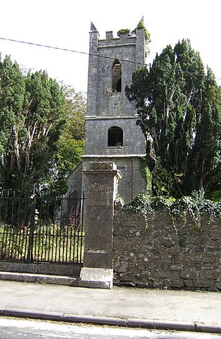
The ruins of the old parish church in Laghcloon townland, east of Liscannor, features several arches and prominent moldings in its walls.
Despite the alleged early Christian roots, written documentation only goes back to the 14th century. Most of the ornamentation that survives today dates to much later. The nave features a holy water font, a window and a broken bell chamber on the west wall. A high semi-Gothic arch divides the nave from the chancel, which may be a later addition to the church. A recess in the north wall reportedly served as a tomb like a similar structure in Kilfenora Cathedral. A prominent hood is crowned by a mitred head. A recess in the south wall may have once been a window with two Gothic arches topped by a carved head wearing a flat cap. It was reconstructed in a drawing by Thomas Johnson Westropp.[8]:64–5
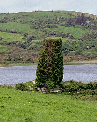
The parish also holds two ruined castles: Dough and Liscannor.[3]
Ecclesiastical parishes
There is a holy well near Birchfield dedicated to Saint Bridget.[3] The devotees and people looking for the cure of illness would visit the well on the eve of the first Sunday of August.[2]
In 1834 there were 3,571 Roman Catholics and 24 Protestants.[4] As of 1837 the parish was part of the Catholic district of Liscanor, which also includes the parish of Killaspuglenane.[3]
Lahinch or Lehinch is a small town on Liscannor Bay, on the northwest coast of County Clare, Ireland. It lies on the N67 national secondary road, between Milltown Malbay and Ennistymon, roughly 75 kilometres (47 mi) by road southwest of Galway and 68 kilometres (42 mi) northwest of Limerick. The town is a seaside resort and is home to the Lahinch Golf Club. It has become a popular surfing location.
Liscannor is a coastal village in County Clare, Ireland. It is located on the R478 road between Lahinch and Doolin, close to the Cliffs of Moher. As of the 2016 census it had a population of 113.
Kilshanny is a village and a civil parish in County Clare, Ireland.
Mac Creiche of Liscannor is described by various old texts as an early Irish saint, a hermit who slew monsters and persuaded kings to submit to him through miracles. He was probably not a historical figure. The stories of his life are most likely derived from earlier pagan legends, and he may be equated with a pagan god.
Rath is a civil parish in the barony of Inchiquin in County Clare, Ireland.
Kiltenanlea or Kiltonanlea is a civil parish in County Clare, Ireland.
Kilmacduane is a civil parish in County Clare, Ireland. It contains the villages of Cooraclare and Cree.
Doonbeg (Killard) (Irish: Cill Ard) is a civil parish on the Atlantic coast of County Clare in Ireland. It is also an ecclesiastical parish in the Roman Catholic Diocese of Killaloe. The largest population centre in the parish is the village of Doonbeg.
Kilfarboy is a civil parish in County Clare, Ireland. There is also a Catholic parish with the same name. The largest population centre in the parish is Milltown Malbay.
Kilmurry-Negaul is a civil parish and a village in County Clare, Ireland.
Killeely is a civil parish that lies partly in County Clare and partly in County Limerick in Ireland.
Killuran is a civil parish in County Clare, Ireland. It contains the village of O'Callaghans Mills. It is united with the civil parish of Kilkishen in the Catholic parish of O'Callaghans Mills.
Kilmaleery is a civil parish in County Clare, Ireland. It is part of the Catholic parish of Newmarket-on-Fergus.
Killilagh or Killeilagh is a civil parish in County Clare, Ireland. It contains the village of Doolin.
Kiltoraght is a civil parish in County Clare, Ireland. It is just south of Kilfenora and is part of Catholic parish of St. Fachanan.
Gleninagh or Glaninagh is a civil parish in County Clare, Ireland. It lies in the extreme northwest of the Burren, on the south of the mouth of Galway Bay. It is known for the well-preserved L-plan Gleninagh Castle, a 16th-century tower house. The parish also contains the lighthouse on Black Head.
Kilmanaheen is a civil parish in County Clare, Ireland. It contains the market town of Ennistymon.
Killaspuglonane is a civil parish in County Clare, Ireland.
Killeany or Kilhenny, Kilheny is a civil parish in County Clare, Ireland. It lies in the Burren region of the northwest of the county.
Kilcorney is a civil parish in County Clare, Ireland. It lies in the Burren region of the northwest of the county.
References
Notes
↑ The Cliffs of Moher are named after Moher ui Ruaidhin (O'Ruaidhin's fort), an old stone fort that stood near Hag's Head. The fort was pulled down at the start of the 19th century and its stones used to build a telegraph tower.[2]
* (part) refers to civil parishes which span two different baronies
This page is based on this Wikipedia article Text is available under the CC BY-SA 4.0 license; additional terms may apply. Images, videos and audio are available under their respective licenses.