
O'Brien's Bridge or O'Briensbridge is a village in east County Clare, Ireland, on the west bank of the River Shannon, in a civil parish of the same name. It is named for the bridge across the Shannon at that point, built by Turlough O'Brien in 1506.
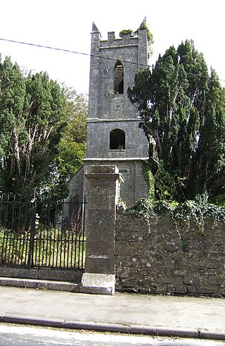
Tuamgraney is a village in eastern County Clare in the west of Ireland and a civil parish by the same name. Situated a kilometre from the River Graney which flows into Lough Derg, it is an ancient settlement, noted for St Cronán's Church, said to be the oldest church in constant use in Ireland
Ogonnelloe is a civil parish in east County Clare, Ireland, situated on the R463 regional road between Scariff and Killaloe and in the surrounding hills. It forms part of the Catholic parish of the same name.

Clonlea or Clonleigh is a civil parish in County Clare, Ireland. The main settlement is the village of Kilkishen. It is part of the Catholic parish of O'Callaghans Mills.

Killaloe is a civil parish in County Clare, Ireland. The main settlement is the town of Killaloe.
Bunratty Lower is a barony located in County Clare, Ireland. This ancient unit of land division is in turn divided into fourteen civil parishes.
Bunratty Upper is a barony in County Clare, Ireland. This ancient geographical division of land is in turn divided into six civil parishes.

Tulla Upper is a barony in County Clare, Ireland. This ancient geographical division of land is in turn divided into seven civil parishes.
Inchiquin is a barony in County Clare, Ireland. This geographical unit of land is one of 11 baronies in the county. Its chief town is Corofin. It is administered by Clare County Council.
Kilfinaghta is a civil parish of County Clare, Ireland, located to the east of Sixmilebridge and northeast of Shannon.
Killokennedy is a civil parish in County Clare, Ireland.

Kilseily is a civil parish in County Clare, Ireland. The main settlement is the village of Broadford.
Kiltenanlea or Kiltonanlea is a civil parish in County Clare, Ireland.
Killanena is a townland and formerly a district electoral division (DED) in County Clare, Ireland, in the Catholic parish of Killanena.
Kilmurry-Negaul is a civil parish and a village in County Clare, Ireland.
Crusheen, formerly called Inchicronan, is a civil parish in County Clare, Ireland. There is also a catholic parish Crusheen, covering the same area. The parish lies to the northeast of Ennis. It contains the villages of Crusheen and Ballinruan.
Killeely is a civil parish that lies partly in County Clare and partly in County Limerick in Ireland.

Inishcaltra is a civil parish in the barony of Leitrim in County Clare, Ireland. The main settlement in the parish is the village of Mountshannon. It is noted for the eponymous island of Inis Cealtra, which is an ancient Christian monastic site. In the Catholic Church, the parish is part of the ecclesiastical parish of Mountshannon (Clonrush).
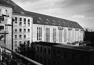
St. Patrick's, or Kilquane, is a civil parish that is situated on both banks of the River Shannon near the city of Limerick in Ireland. It is unusual in that it is distributed over three baronies: Bunratty Lower, Clanwilliam and the barony of the City of Limerick. Besides the suburbs of the city, it also contains the villages of Ardnacrusha and Parteen. It is known for the Ardnacrusha power plant, a major hydroelectric plant.
Leitrim is a barony in Ireland that lies partly in County Galway and partly in County Clare. It is located in the south-eastern corner of County Galway and the north-eastern corner of County Clare. Prior to 1898, the entire barony was contained in County Galway. The Local Government (Ireland) Act 1898 split the barony: part of the barony was transferred to County Clare. Leitrim is bounded, clockwise from the southwest, by the Clare baronies of Tulla Upper and Tulla Lower; the Galway baronies of Loughrea to the west, Kilconnell to the north, and Longford to the east; and by Lough Derg to the south and southeast. It measures 20 miles (32 km) from north to south and 9.5 miles (15.3 km) from east to west.

