
County Clare is a county in Ireland, in the Mid-West Region and the province of Munster, bordered on the west by the Atlantic Ocean. Clare County Council is the local authority. The county had a population of 118,817 at the 2016 census. The county town and largest settlement is Ennis.
A townland is a small geographical division of land used in Ireland and in the Western Isles in Scotland. The townland system is of Gaelic origin, pre-dating the Norman invasion, and most have names of Irish origin. However, some townland names and boundaries come from Norman manors, plantation divisions, or later creations of the Ordnance Survey. The total number of inhabited townlands in Ireland was 60,679 in 1911. The total number recognised by the Irish Place Names database as of 2014 was 61,098, including uninhabited townlands, mainly small islands.

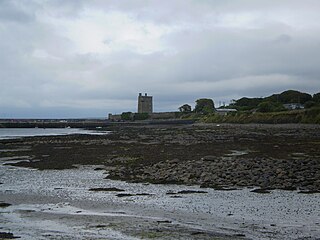
Inis Cathaigh or Scattery Island is an island in the Shannon Estuary, Ireland, off the coast of Kilrush, County Clare. The Irish name Inis Cathaigh was formerly anglicised Iniscathy, which later became Iniscattery and finally Scattery. The island is home to a lighthouse, a ruined monastery, an Irish round tower and the remains of an artillery battery. The last residents left in 1969.

Kildysart, officially Killadysert, is a village in County Clare, Ireland and a civil and Roman Catholic parish by the same name that surrounds the village.
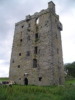
Carrigaholt is a small fishing village in County Clare, Ireland, a castle and a Catholic parish by the same name. The area was officially classified as part of the West Clare Gaeltacht; an Irish-speaking community; until 1956.

Tullig is a townland and small village located in the Loop Head peninsula in County Clare, Ireland.
Moyarta is a civil parish in County Clare, Ireland. It lies on the Loop Head peninsula between the Atlantic Ocean and the Shannon Estuary. The parish contains the villages of Carrigaholt and Doonaha.
Clonderalaw is an historical barony in County Clare, Ireland. Baronies are geographical divisions of land that are in turn is divided into civil parishes.
Bunratty Lower is a barony located in County Clare, Ireland. This ancient unit of land division is in turn divided into fourteen civil parishes.
Bunratty Upper is a barony in County Clare, Ireland. This ancient geographical division of land is in turn divided into six civil parishes.
Tulla Upper is a barony in County Clare, Ireland. This ancient geographical division of land is in turn divided into seven civil parishes.
Tulla Lower is a barony in County Clare, Ireland. This ancient geographical division of land is in turn divided into eight civil parishes.
Islands(Irish: Na hOileáin) is a barony located in County Clare, Ireland. This ancient unit of land division is in turn divided into five civil parishes.
Ibrickane is one of the ancient baronies of Ireland. It is a geographical division of County Clare. It is sub-divided into four civil parishes.
Inchiquin is a barony in County Clare, Ireland. This geographical unit of land is one of 11 baronies in the county. Its chief town is Corofin. It is administered by Clare County Council.

Kilballyowen is a civil parish and a Catholic parish in County Clare, Ireland. It is located at the end of the Loop Head Peninsula which extends into the Atlantic Ocean to the north of the Shannon Estuary. The parish contains the villages of Cross, Kilbaha and Carrigaholt.
Killeely is a civil parish that lies partly in County Clare and partly in County Limerick in Ireland.
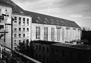
St. Patrick's, or Kilquane, is a civil parish that is situated on both banks of the River Shannon near the city of Limerick in Ireland. It is unusual in that it is distributed over three baronies: Bunratty Lower, Clanwilliam and the barony of the City of Limerick. Besides the suburbs of the city, it also contains the villages of Ardnacrusha and Parteen. It is known for the Ardnacrusha power plant, a major hydroelectric plant.

Kilkee, formerly Kilfearagh, is a Catholic parish in County Clare, Ireland. Kilfearagh is also a civil parish that covers the same area. Both lie on the Loop Head peninsula between the Atlantic ocean and the Shannon Estuary. The main settlement is the resort town of Kilkee. The parish contains many ruins, some dating to the early days of Christianity in Ireland.
Colonel Crofton Moore Vandeleur was an Irish landowner and Conservative Party politician from Kilrush in County Clare. He sat in the House of Commons of the United Kingdom from 1859 to 1874 as a Member of Parliament (MP) for Clare.

