
Doora is a village and civil parish in County Clare, Ireland, just to the east of the town of Ennis.

Spancil Hill, or in original spelling Spancilhill, is a traditional Irish folk ballad composed by Michael Considine (1850–73), who was born in Spancil Hill and migrated to the US. It bemoans the plight of the Irish emigrants who so longed for home from their new lives in America. This song is sung by a man who longs for his home in Spancill Hill, County Clare, his friends and the love he left there. All the characters and places in this song are real.
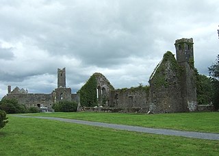
Quin is a village in southeast County Clare, Ireland. The name also refers to a civil parish in the barony of Bunratty Upper, and to an ecclesiastical parish of the same name. The main attraction in the vicinity is Quin Abbey, the ruins of Franciscan friary, which is open to the public. Although roofless, much of the structure remains and is relatively well-preserved. The abbey was built on the foundations of an earlier Norman castle; the foundations of three corner towers can still be seen.

Dysert is a civil parish in County Clare, Ireland. The parish was formerly called Dysert O’Dea, from its having been the territory of the sept of that name. It is part of the ecclesiastical parish of Dysart and Ruan. The ruins of O'Dea Castle and a 12th-century church of Dysert O'Dea Monastery are in the townland of the same name.

Spancill Hill or Spancilhill is a hill and adjacent dispersed settlement in County Clare, Ireland. The historic hamlet of Spancilhill was by the fair green, which is still the site of the Spancill Hill Fair, which occurs annually on 23 June. Houses are concentrated slightly south at Cross of Spancilhill, where the R352 road between Ennis to the west and Tulla to the east crosses a local road between Barefield to the north and Quin to the south.
Kilnasoolagh is a civil parish in County Clare, Ireland, and a townland within that parish. Church records mention the parish in 1256.
Tomfinlough is a civil parish in County Clare, Ireland. A Christian establishment was first made here around 540 AD. The parish lands were often raided by Irish, Viking, Norman and English forces in the years that followed. The church was allowed to fall into ruins during the period when the Catholic Church was penalized in Ireland.
Clonloghan is a civil parish of County Clare, Ireland, located 21.7 kilometres (13.5 mi) by road northwest of Limerick, just north of Shannon.
Clooney is a civil parish in County Clare, Ireland. It comprises the hamlets of Clooney, to the east of Ennistymon.
Bunratty Upper is a barony in County Clare, Ireland. This ancient geographical division of land is in turn divided into six civil parishes.
Drumline is a civil parish of County Clare, Ireland, located about 20 kilometres (12 mi) northwest of Limerick, just north of Shannon.
Kilconry is a civil parish of County Clare, Ireland, located about 25 kilometres (16 mi) northwest of Limerick, west of Shannon on the estuary of the River Shannon. The main village in the area is Ballycalla/Ballcally and it contains the Shannon Golf Club and Shannon Airport.
Kilfinaghta is a civil parish of County Clare, Ireland, located to the east of Sixmilebridge and northeast of Shannon.

Templemaley is a civil parish in County Clare, Ireland. It contains the village of Barefield and part of the town of Ennis.
Kilmurry-Negaul is a civil parish and a village in County Clare, Ireland.

Kilraghtis is a civil parish in County Clare, Ireland. It covers an area northeast of the town of Ennis, and includes the Ennis suburb of Roslevan.
Crusheen, formerly called Inchicronan, is a civil parish in County Clare, Ireland. There is also a catholic parish Crusheen, covering the same area. The parish lies to the northeast of Ennis. It contains the villages of Crusheen and Ballinruan.
Killeely is a civil parish that lies partly in County Clare and partly in County Limerick in Ireland.
St. Patrick's, or Kilquane, is a civil parish situated on both banks of the River Shannon near the city of Limerick in Ireland. It is unusual in that it is distributed over three baronies: Bunratty Lower, Clanwilliam and the barony of the City of Limerick. Besides the suburbs of the city, it also contains the villages of Ardnacrusha and Parteen. It is known for the Ardnacrusha power plant, a major hydroelectric plant.

