Year | Pop. | ±% |
---|---|---|
1821 | 315 | — |
1831 | 506 | +60.6% |
1841 | 562 | +11.1% |
1851 | 429 | −23.7% |
1861 | 394 | −8.2% |
1871 | 415 | +5.3% |
1881 | 321 | −22.7% |
1891 | 286 | −10.9% |
1901 | 251 | −12.2% |
1911 | 242 | −3.6% |
1926 | 217 | −10.3% |
1936 | 183 | −15.7% |
1946 | 170 | −7.1% |
1951 | 146 | −14.1% |
1956 | 139 | −4.8% |
1961 | 106 | −23.7% |
1966 | 94 | −11.3% |
2002 | 108 | +14.9% |
2011 | 128 | +18.5% |
2016 | 113 | −11.7% |
[2] [3] [4] [5] [6] [1] |
Liscannor (Irish : Lios Ceannúir, meaning ' ringfort of Ceannúr') [7] [8] is a coastal village in County Clare, Ireland. It is located on the R478 road between Lahinch and Doolin, close to the Cliffs of Moher. As of the 2016 census it had a population of 113. [1]
Lying on the west coast of Ireland, on Liscannor Bay, the village is located on the R478 regional road between Lahinch, to the east, and Doolin, to the north. The Cliffs of Moher are about 5 km (3.1 mi) north west of the village. Between Lahinch and Liscannor lies the small village of Moymore. Liscannor is located in the civil parish of Kilmacrehy. [9]
Liscannor probably takes its name from an old fort that was located here. [8] Lis meaning a "fort" and Cannor a corruption of the name "Connor". [10] : 66
The area around Liscannor was part of the Barony of Corcomroe, controlled by the O'Connor family.
At least 30 ships of the Spanish Armada, sent to invade England in the summer of 1588, were lost along the coast of Ireland, mainly along the western seaboard. The oar-powered galleass Zuñiga was damaged, and anchored off-shore of Liscannor. The ship came under surveillance by the High Sheriff of Clare and by crown forces, and those Spanish sailors who had come ashore had to withdraw to their ship. One captive was taken and sent for interrogation. The Zuñiga escaped the coast with favorable winds, and later reached Le Havre. [11]
The village of Liscannor is of late 18th century origin. According to an 1814 survey there were nearly 200 houses in it at the time, and about ten of them had flag roofs. 40 houses were used by fishermen. [10] : 66
While there was once a Gaeltacht (Irish-spealing area) around the Liscannor area, by 1956 the loss of native speakers meant that it could no longer be considered a Gaeltacht area.[ citation needed ]
The Cliffs of Moher are one of Ireland's top visitor attractions, and include a protected colony of cliff-nesting seabirds. The area was designated as a Refuge for Fauna in 1988, and as a Special Protection Area for Birds (SPA) under the EU Birds Directive in 1989. [12]
Cill MacCreiche (Kilmacreehy Church) is first documented in the 14th century, but some of the church's structures, including its Gothic ornamentation, are later additions. [13]
Liscannor Castle was an O'Connor stronghold which, like Dough Castle, later passed to the O'Briens. In 1712, the Earl of Thomond let the estate to William Fitzgerald (annual rent £14). Under the Fitzgerald family, the town began to grow in the later 18th century. [10] : 68
The ruined remains include a six-story tower with a spiral stairway to the east and a lower main building next to it. This latter was described in some detail by Thomas Johnson Westropp in the late 19th century, who noted that it had five floors. [10] : 68–9
Located at a site of pre-Christian Lughnasadh celebrations, [10] : 74 Dabhach Bhríde (or Brigid's Vat) is located near the Cliffs of Moher. Behind the well, on a higher level to which steps lead, is an ancient cemetery. There is a large cross here and a circular path around it, and part of the Rite of the Holy Well is performed in this area known as the Ula Uachtarach or upper sanctuary.
The well, dedicated to Brigid of Kildare, is in the lower ground, the Ula íochtarach or lower sanctuary, enclosed in a little house which contains votive offerings left by pilgrims. [14]
The well has been a pilgrimage site since at least the 1830s, when following a personal cure which he attributed to the waters of the well, Cornelius O'Brien had the well house built. [10] : 74 Pilgrims from elsewhere in County Clare and from the Aran Islands came to Liscannor. Pattern Days on which large groups attended included St Brigid's Day (1 February) and Garland Sunday (late July). [10] : 74
The harbour was built between 1825 and 1831 for £2,900, of which £2,000 was a government grant. [15]
In modern times, the harbour has a number of fishing vessels moored there as well as smaller boats using it is a launching site for sea fishing/recreational sports. During summer months there is also a ferry service to the base of the Cliffs of Moher as well as to the Aran Islands.
In the past the harbour was a hub for fishing vessels as well as a location to export locally quarried Liscannor Stone and to receive in coal supplies. Some historical documents note that due to the silting of the harbour, ships could only carry approximately 380 tonnes into port. At low tides ships had to be winched into harbour. A currach would bring the rope out to the ship. Locally quarried flag was cut and polished beside the harbour and winched onto ships by steam crane. These slabs were transported to several British cities.[ citation needed ]
The engineer John Philip Holland (1841–1914), who was born in Liscannor, developed some of the first submarines commissioned by the US Navy, Japanese Navy and Royal Navy. [16] Castle Street, on which Holland was born, was renamed 'Holland Street' in his honour. [17] [18]
There are several memorials to Holland in the area, including one erected on the 50th anniversary of his death in 1964. [17] A further memorial, donated by the Submarine Veterans of the US Navy, [10] : 66 was erected in Liscannor in 1977. [19]
A visitor centre, the John P. Holland Centre, opened in 2016. [20] A statue of Holland, originally on public display on Liscannor's Main Street, [21] was moved into the centre, [22] alongside displays about his life and work with submarines. [22] [23]
St Brigid's Church in Liscannor was built in 1858. It is a single-cell, four-bay church built of rubble masonry. A new roof was later added but the gallery, y-mullioned windows and semi-Tudor door were retained. Although the construction of a round tower was suggested in the 1920s, this Touheran tower which would have housed the bell as well as cottage industries on the lower floors was never built. [10] : 68
Liscannor has been referred to as "the Pope's Own Parish". Located in the Diocese of Kilfenora, of which the Pope is the Bishop and the Bishop of Galway is the Apostolic Administrator, Liscannor is a mensal parish, i.e. directly under the direct authority of the bishop. [10] : 68
The church of Moymore was built in 1877, on an elevated site overlooking the bay. There was no church previously at this location. Before that the people of the area attended Mass in a small thatched chapel a quarter mile to the east in Caheraderry (Derry).[ citation needed ]
The Caheraderry (Derry) church probably dates from the 17th century penal times, built either to facilitate travelling friars or possibly as an out-chapel or hermitage for Kilmacreehy Church. Beside the ruins stand two small one-room attached cottages. According to local tradition, one of these cottages was a sheebeen known as Gleeson's and the other a schoolhouse, where a hedge-schoolmaster taught.[ citation needed ]
Bus Éireann route 350 links Liscannor to several locations: Ennis, Ennistymon, Cliffs of Moher, Doolin, Lisdoonvarna and Galway. There are a number of journeys each way daily. Onward rail and bus connections are available at Ennis and Galway.
Liscannor won a county title in 1940 – with a combined team from the broader North Clare area. Liscannor GAA Club was reformed in 1985 as a separate entity after players from the area had played with The St Michaels team for a number of years. Liscannor were promoted to Intermediate ranks after winning the Junior title in their first year after reforming in 1985. Liscannor also won the league title in 1985. An intermediate title followed in 1988, but Liscannor were to revert to the Intermediate grade after one year at Senior level.[ citation needed ] It would be 12 years later, in 2000, before Liscannor returned to the Senior Grade.[ citation needed ]
Moher Celtic is the local football club. They have reached two Clare Cup finals in their history but have been edged out on both occasions. [24]
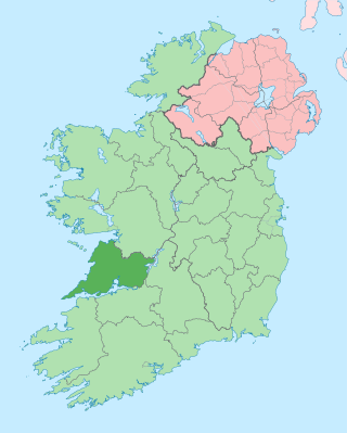
County Clare is a county in the province of Munster in the Southern part of the republic of Ireland, bordered on the west by the Atlantic Ocean. Clare County Council is the local authority. The county had a population of 127,938 at the 2022 census. The county seat and largest settlement is Ennis.
The Cliffs of Moher are sea cliffs located at the southwestern edge of the Burren region in County Clare, Ireland. They run for about 14 kilometres. At their southern end, they rise 120 metres (390 ft) above the Atlantic Ocean at Hag's Head, and, 8 kilometres to the north, they reach their maximum height of 214 metres (702 ft) just north of O'Brien's Tower, a round stone tower near the midpoint of the cliffs, built in 1835 by Sir Cornelius O'Brien, then continue at lower heights. The closest settlements are the villages of Liscannor 6 km to the south, and Doolin 7 km to the north.
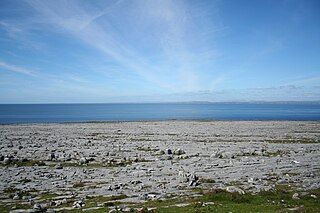
The Burren is a karst/glaciokarst landscape centred in County Clare, on the west coast of Ireland. It measures around 530 square kilometres (200 sq mi), within the circle made by the villages of Lisdoonvarna, Corofin, Gort and Kinvara. The area includes such natural features as Mullaghmore hill and Ailladie cliffs, and historic monuments such as Poulnabrone dolmen and Caherconnell Stone Fort. The Burren National Park covers a small part of the Burren and is the smallest of the eight National Parks in Ireland, while the adjacent territory, including the Cliffs of Moher, is included in the Burren and Cliffs of Moher Geopark.
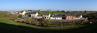
Doolin is a coastal village in County Clare, Ireland, on the Atlantic coast. It is southwest of the spa town of Lisdoonvarna and 4 miles from the Cliffs of Moher. It is a noted centre of traditional Irish music, which is played nightly in its pubs, making it a popular tourist destination. There are numerous nearby archaeological sites, many dating to the Iron Age and earlier. Doonagore Castle and Ballinalacken Castle are also in the area. The area was officially classified as part of the West Clare Gaeltacht prior to the 1950s, and maintains a connection with Irish-speaking areas - including via its maritime connection with the Aran Islands.
Ennistymon or Ennistimon is a country market town in County Clare, near the west coast of Ireland. The River Inagh, with its small rapids known as the Cascades, runs through the town, behind the main street. A bridge across the river leads to nearby Lahinch. The town is at the junction of the N67 and N85 roads.
Lahinch or Lehinch is a small town on Liscannor Bay, on the northwest coast of County Clare, Ireland. It lies on the N67 national secondary road, between Milltown Malbay and Ennistymon, roughly 75 kilometres (47 mi) by road southwest of Galway and 68 kilometres (42 mi) northwest of Limerick. The town is a seaside resort and is home to the Lahinch Golf Club. It has become a popular surfing location.
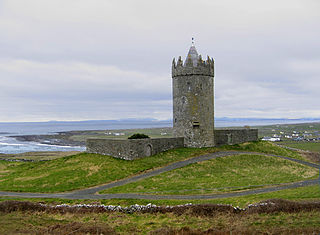
Doonagore Castle is a round 16th-century tower house with a small walled enclosure located about 1 km south of the coastal village of Doolin in County Clare, Ireland. Its name may be derived from Dún na Gabhair, meaning "the fort of the rounded hills" or the "fort of the goats". Doonagore Castle is at present a private holiday home, inaccessible to the public.
Liscannor Bay is a bay on the west coast of Ireland in County Clare. Hag's Head provides the northern border for the bay and Cream Point is the southern boundary. The village of Liscannor is located on the north side of the bay, while the village of Lahinch is on the eastern end of the bay.
Kilshanny is a village and a civil parish in County Clare, Ireland.
Cornelius O'Brien (1782–1857) was an Irish politician, Member of Parliament and landowner in County Clare.
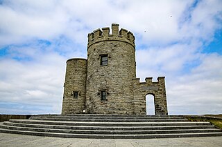
O'Brien's Tower marks the highest point of the Cliffs of Moher in County Clare, Ireland. It is located a short distance from the villages Doolin and Liscannor.
Doonbeg is a village in west County Clare, Ireland on the Atlantic coast. The surrounding natural environment has supported its development as a tourist resort. The area was officially classified as part of the West Clare Gaeltacht, an Irish-speaking community, until 1956.
The Burren Way is a long-distance trail in County Clare, Ireland. It is 114 kilometres long, begins in Lahinch and ends in Corofin, crossing The Burren, one of the largest karst limestone landscapes in Europe.
The Burren and Cliffs of Moher Geopark is an internationally designated area of geological interest in The Burren region of County Clare, Ireland. It is the third Geopark to be designated in Ireland, and is recognised at both European and global levels.
Dough Castle is a ruined tower house at Lahinch in County Clare, western Ireland. It was established by the O'Conors in the early 14th century, but nothing remains of the original structures.
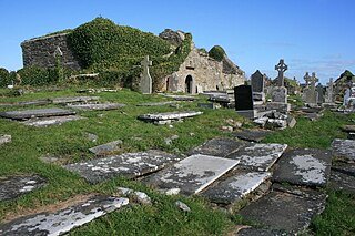
Kilmacrehy, sometimes also Kilmacreehy, is a civil parish in County Clare, Ireland. The ruins of the old parish church lie near the coastal village of Liscannor, which is also a part of the parish.
The Wild Atlantic Way is a tourism trail on the west coast, and on parts of the north and south coasts, of Ireland. The 2,500 km driving route passes through nine counties and three provinces, stretching from County Donegal's Inishowen Peninsula in Ulster to Kinsale, County Cork, in Munster, on the Celtic Sea coast.
Killilagh or Killeilagh is a civil parish in County Clare, Ireland. It contains the village of Doolin.
Killaspuglonane is a civil parish in County Clare, Ireland.
The R478 road is a regional road in Ireland. It is a loop road from the N67 in County Clare. Part of the road is on the Wild Atlantic Way. The road passes along, and is the only road access to, the Cliffs of Moher.
In 1964, the village of his birth, Liscannor, erected a plaque to commemorate the fiftieth anniversary of his death. The town also renamed Castle Street, calling it 'Holland Street' in his honour
John Philip Holland (1841-1914) was born in Castle Street , now Holland Street , Liscannor
a new John P Holland centre has opened in his birthplace of Liscannor in County Clare