Kilmurry-Negaul

Last updated

Kilmurry-Negaul
Cill Mhuire na nGall
Civil parish
Disused church at Kilmurry, Co. Clare - geograph.org.uk - 582150.jpg
Disused church at Kilmurry by the R462 Sixmilebridge road
Ireland adm location map.svg
Red pog.svg
Kilmurry-Negaul
Location in Ireland
Coordinates: 52°46′40″N8°46′58″W / 52.7778°N 8.7828°W / 52.7778; -8.7828
Country Ireland
Province Munster
County County Clare
Elevation
45 m (148 ft)
Population
 (2016) [1]
280
 (Kilmurry village)
Time zone UTC+0 (WET)
  Summer (DST) UTC-1 (IST (WEST))
Irish Grid Reference Q807509

Kilmurry-Negaul (Irish : Cill Mhuire na nGall [lower-alpha 1] ) is a civil parish and a village in County Clare, Ireland.

Contents

Location

Kilmurry-Negaul is a civil parish containing a village with the name Kilmurry. It was within the barony of Tulla Upper, but as of 1845 had recently been transferred to the barony of Bunratty Lower. It is 3.5 by 1.5 miles (5.6 by 2.4 km) and covers 2,917 acres (1,180 ha). The village of Kilmurry is 2.5 miles (4.0 km) north of Sixmilebridge on the road to Quin. [3] There is a large tract of fine arable country of a light limestone where the parishes of Quinn, Clonlea and Kilmurry-Negral meet. [4]

Antiquity

The name Kilmurry means "Church of the Virgin Mary", but originally the parish may have been dedicated to an Irish saint. A holy well near the old church is dedicated to Saint Tobar Faoile. The castle of Rossroe, well-preserved in 1897, belonged to Fineen, son of Loghlen MacNamara, in 1580. The castle of Drumullan was in 1580 the property of Covea, son of Mahone MacNamara. [5] The parish lay in MacNamara territory, and the families of this powerful sect would not abandon the Catholic faith. [6]

During the reign of King William III of England (1689–1702) John Lawson, an Englishman, was given the rectories of Quin, Tulloo, Cluony, Dowry, Templemaley, Kilraghtis and Kilmurry-Negaul. [7] Opposite the record of this appointment was the note, "No cure served at present; noe church in repaire; the country all wast." These had been seven of the best parishes in the county. [6]

On 18 March 1790 the vicarages of Kilseily, Bunratty, Clonlea, Clonloghan, Finogh, Kilconry, Killuran, Kilfinaghty, Kilmurrynegaul, Kilnoe and Tomfinlough were episcopally united in the Church of Ireland. [8] In 1810 the Church of Ireland rectory of Kilmurraynegaul was valued in the King's books at £0.6.8 sterling. It was one of the parishes that made up the Union of Kilseily. [9] As of 1837 the civil parish was part of the Catholic union of Sixmilebridge. [10]

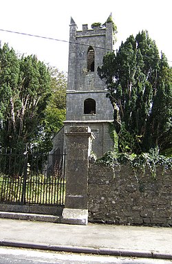
The population was 980 in 1821 and had fallen to 628 in 1831. [11] In 1841 the population had risen to 699 in 101 houses. [3] The old burial ground in the village had the ruins of an old church in 1837. [10] By 1897 all traces of the church had gone, but the graveyard surrounding it remained in use. [5]

Townlands

The townlands are Cloonmunnia, Cragroe, Drumullan, Kilcornan, Kilkishen, Kilkishen Demesne, Kilmurry, Knocknalappa, Rosroe, Shandangan East and Shandangan West. [12]

Related Research Articles

<span class="mw-page-title-main">Cratloe</span> Village in County Clare, Ireland

Cratloe is a village in County Clare, Ireland, situated between Limerick and Shannon in the mid-west of Ireland. It is possible that the name derives from Croit-shliabh meaning "hump-backed hill", referring to Woodcock Hill. The present-day parish of Cratloe consists of the former parish of Kilfintinan and a portion of the contemporary parish of Killeely. This was agreed upon by priests in the 18th century, who claimed there were not enough members of the clergy to operate fully in both parishes.

<span class="mw-page-title-main">Sixmilebridge</span> Village in County Clare, Ireland

Sixmilebridge, is a large village in County Clare, Ireland. Located midway between Ennis and Limerick city, the village is a short distance away from the main N18 road.

<span class="mw-page-title-main">Kilkishen</span> Village in County Clare, Ireland

Kilkishen is a village in southeast County Clare, Ireland. The village is 8 kilometres (5 mi) east of Quin and 14 kilometres (8.7 mi) north of Shannon.

Kilmurry Ibrickane is a civil parish in County Clare, Ireland, The parish is part of the historic barony of Ibrickane. In 1837, it was co-extensive with the parish of the Established Church and of the Catholic Church. The civil parish contains the tiny settlement of Kilmurry which was the location of the church before the Cromwellian conquest of Ireland. Today, an ecclesiastical parish in the Roman Catholic Diocese of Killaloe of the same name exists which covers part of the civil parish. In the Church of Ireland, the parish is part of the "Drumcliffe Union with Kilnasoolagh" which covers the western part of the county of Clare, roughly that part located to the west of the M18 motorway.

<span class="mw-page-title-main">Kilmacrehy</span> Civil parish in Clare, Ireland

Kilmacrehy, sometimes also Kilmacreehy, is a civil parish in County Clare, Ireland. The ruins of the old parish church lie near the coastal village of Liscannor, which is also a part of the parish.

<span class="mw-page-title-main">Feenagh, County Clare</span> Civil parish in Clare, Ireland

Feenagh, or Finogh, Phinagh is a civil parish in County Clare, Ireland.

<span class="mw-page-title-main">Clonlea</span> Civil parish in Clare, Ireland

Clonlea or Clonleigh is a civil parish in County Clare, Ireland. The main settlement is the village of Kilkishen. It is part of the Catholic parish of O'Callaghans Mills.

Drumline is a civil parish of County Clare, Ireland, located about 20 kilometres (12 mi) northwest of Limerick, just north of Shannon.

Kilfinaghta is a civil parish of County Clare, Ireland, located to the east of Sixmilebridge and northeast of Shannon.

<span class="mw-page-title-main">Kilseily</span> Civil parish in Munster, Ireland

Kilseily is a civil parish in County Clare, Ireland. The main settlement is the village of Broadford.

Kiltenanlea or Kiltonanlea is a civil parish in County Clare, Ireland.

<span class="mw-page-title-main">Killofin</span> Parish in County Clare, Ireland

Killofin is a civil parish in County Clare in Ireland. It contains the village of Labasheeda and is part of the Catholic parish of Kilmurry McMahon.

Killeely is a civil parish that lies partly in County Clare and partly in County Limerick in Ireland.

Kilfintinan is a civil parish in County Clare, Ireland. It is part of the Catholic parish of Cratloe.

<span class="mw-page-title-main">St Patrick's (civil parish, Clare and Limerick)</span> Parish in Munster, Ireland

St. Patrick's, or Kilquane, is a civil parish that is situated on both banks of the River Shannon near the city of Limerick in Ireland. It is unusual in that it is distributed over three baronies: Bunratty Lower, Clanwilliam and the barony of the City of Limerick. Besides the suburbs of the city, it also contains the villages of Ardnacrusha and Parteen. It is known for the Ardnacrusha power plant, a major hydroelectric plant.

<span class="mw-page-title-main">Killuran</span> Civil parish in County Clare, Ireland

Killuran is a civil parish in County Clare, Ireland. It contains the village of O'Callaghans Mills. It is united with the civil parish of Kilkishen in the Catholic parish of O'Callaghans Mills.

<span class="mw-page-title-main">Kilmaleery</span> Civil parish in County Clare, Ireland

Kilmaleery is a civil parish in County Clare, Ireland. It is part of the Catholic parish of Newmarket-on-Fergus.

<span class="mw-page-title-main">Killilagh</span> Civil parish in County Clare, Ireland

Killilagh or Killeilagh is a civil parish in County Clare, Ireland. It contains the village of Doolin.

<span class="mw-page-title-main">Kilmanaheen</span> Civil parish in County Clare, Ireland

Kilmanaheen is a civil parish in County Clare, Ireland. It contains the market town of Ennistymon.

Killeany or Kilhenny, Kilheny is a civil parish in County Clare, Ireland. It lies in the Burren region of the northwest of the county.

References

Notes

  1. The name Cill Mhuire na nGall, meaning "Church of Mary of the Standing Stone, had probably become obsolete by the 17th century. However, in the 20th century it was revived, and helps distinguish this parish from the many other places named Kilmurry. [2]

Citations

  1. "Kilmurry (Ireland) Census Town". City Population. Retrieved 26 July 2021.
  2. Cill Mhuire na nGall, Placenames Database of Ireland.
  3. 1 2 Parliamentary Gazeteer of Ireland 1846, p. 522.
  4. Lewis 1837b, p. 332.
  5. 1 2 Frost 1897.
  6. 1 2 White 1893, p. 290.
  7. Dwyer 1878, p. 426.
  8. Carlisle 1810, p. 505.
  9. Carlisle 1810, p. 497.
  10. 1 2 Lewis 1837.
  11. Accounts and Papers 1833, p. 20.
  12. Map of Kilmurry-Negaul Parish showing Townlands.

Sources